Maps of Regierungsbezirk Tübingen

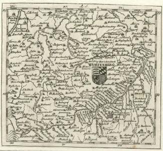
Würtenberg
Mollova mapová sbírka Hoffmann, Johannes Hoffmann, Johann
Circulus siue Liga Sveviae Vulgo Schwabische Kraiß
1 : 950000 Mollova mapová sbírka Seltzlin, David Plantin, Christoph
Wirtenberg Ducatus. [Karte], in: Le théâtre du monde, ou, Nouvel atlas contenant les chartes et descriptions de tous les païs de la terre, Bd. 1, S. 260.
1 Karte aus Atlas Blaeu, Willem Janszoon und Blaeu, Joan Blaeu, Willem Janszoon
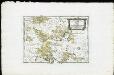
Wirtenberg Ducatus. [Karte], in: Theatrum orbis terrarum, sive, Atlas novus, Bd. 1, S. 283.
1 Karte aus Atlas Blaeu, Joan Blaeu, Willem Janszoon
WIRTENBERG | DVCATVS
[Amsterdam : Joan Blaeu]
Wirtenberg Dvcatvs
1 : 530000 Mollova mapová sbírka Mercator, Gerhard
Imp. Caes. Carolo VI. Avgvsto Pio Victori gentis svae sideri felicissimo chorographiam hanc exhibentem primar. Regionvm Habspvrgicar sitvm positvmq brevibvs exterarvm ditionvm intervallis vt permistvm nec non vltimos Imperii Germ. Terminos perpetva transitvvm obsidionvm Hibernorvm Coactionvm vexatione agitatos antiqvae fidei et invictae testes pietatis svpplex dicat Provincia Brisgoia Avst. Ant. MDCCXVIII. Cum Privilegio Sac. Caes. Majestatis
1 : 241000 Mollova mapová sbírka Homann, Johann Baptist Homann, Johann Baptista
Accurata Delineatio Brisgoviae cum Civitatibus Silvestribus Austriae Anterioris, tanquam Limitum et Terminorum Imperii Rom. Germanici versus Occasum cura et impensis
1 : 242000 Mollova mapová sbírka Seutter, Matthäus Seutter, Matthäus
Stuttgart

Ducatus Wurtembergiae
1 : 450000 Mollova mapová sbírka Weigel, Christoph K., M. Weigel, Christoph I. - dědici
Nova et accuratißima ducatus Wurtenbergici cum territoriis conterminis designatio
1 : 304000 Württembersko (Německo) Lotter, Tobias Conrad sumtibus Tobiae Conradi Lotteri
Nova et accuratißima ducatus Wurtenbergici cum territoriis conterminis designatio
1 : 304000 Württembersko (Německo) Lotter, Tobias Conrad sumptibus Tobiae Conradi Lotteri
Wirtenberg. dvcatvs accurata descriptio
1 Karte : Kupferdruck ; 38 x 43 cm Gadner; Ortelius s.n.
Partie meridionale de la Souabe
1 Karte : Kupferdruck ; 46 x 65 cm L'Isle; Ottens; Ottens chez R. et I. Ottens geogr
Pars Sueviæ australior
1 Karte : Kupferdruck ; 46 x 61 cm L'Isle; Lotter apud Tobiam Conradum Lotter calcogr
Per Inclyti Circuli Suevici Supremorum Ordinum
1 : 160000 Mollova mapová sbírka Pfeffel, Johann Andreas Homann, Johann Baptista - dědici
Per Inclyti Circuli Suevici Supremorum Ordinum :
1 : 160000 Mollova mapová sbírka Pfeffel, Johann Andreas Pfeffel, Johann Andreas I.
Carte topographique d'Allemagne
1 : 218000 Alsasko (Francie) Jaeger, Johann Wilhelm Abraham Facius, Johann Gottlieb chez I.W.A. Iaeger
Carte topographique d'Allemagne
1 : 218000 Alsasko (Francie) Jaeger, Johann Wilhelm Abraham I. W. A. Iaeger
Des Herzogthums Würtemberg westsüdliche Aemter mit der freyen Reichsstadt Reutlingen
1 Karte : Kupferdruck ; 23 x 26 cm Reilly F. J. J. von Reilly
Partie septentrionale de la Souabe
1 : 280000 par Guillaume De L'Isle A Amsterdam : chez J. Covens et C. Mortier
Geographica provinciarum Sueviae descriptio, 3
4 Blätter : Johann Georg Bodenehr
Partie meridionale de la Souabe
1 Karte : Kupferdruck ; 46 x 62 cm L'Isle; Renard chez l'auteur sur le quai de l'Horloge, chez L. Renard libraire prez de la bourse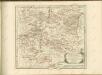
Die Landgrafschaft Nellenburg die Landvogtey Altorf die Grafschaft Hohenberg und die kleinern durch das östreichische Schwaben zerstreuten Besitzungen mit der Stadt Kostanz und den vier Donaustaedten : Nro. 153
Reilly, Franz Johann Joseph von
March. Badensis pars, duc. septentrio Wurtenbergici pars
Bádensko (Německo)
Tubingen
1 : 200000 Herder, Benjamin