Maps of Romania
Le Cours du Danube
1 : 1800000 Mollova mapová sbírka Placide de Sainte-Hélène Inselin, Charles
Illyricum Orientis
1 : 2900000 Mollova mapová sbírka Sanson, Nicolas Covens, Johannes I
Nr. 14. Der Krimkrieg 1854/56
Krim Krimkrieg
Exactissima Tabula, qua tam Danubii Fluvii Pars Inferior
1 : 2000000 Mollova mapová sbírka Visscher, Nicolaes Jansz. Schenk, Peter II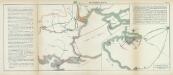
Nr. 10. Der Krimkrieg 1854/56
Krim Krimkrieg
Theatrum belli ad Borysthenem Tyram & Danubium fluvios
1 : 1900000 Balkánský poloostrov Academia scientiarum Petropolitana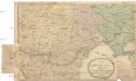
Carte vom Schauplatz des Kriegs
1 : 2200000 Balkánský poloostrov Thomas, C. L. C.L. Thomas
Feuille 33 (E V), uit: Carte géologique internationale de l'Europe : la carte, votée au congrès géologique international de Bologne en 1881, est exécutée conformément aux décisions d'une commission internationale, avec le concours des gouvernements, sous le dir. de M.M. Beyrich et Hauchecorne
Annotatie: Blad 48 gamme des couleurs; blad 49: bladwijzer en titelblad Heinrich Ernst Beyrich 1815-1896; Wi. Hauchecorne Berlin : Reimer / (Berlin: Institut lithographique)
Tooneel des oorlogs aan den Dnieper, Tira en Donauw in den jare 1738 gevoerd
1 : 2500000 I. Punt del. et fecit I. en G. Kondet sculp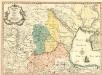
Theatrum Belli ad Borysthenem Tyram & Danubium Fluvios gesti Ao MDCC XXXVIII
1 : 1900000 Mollova mapová sbírka
Daciarum, Moesiarumque, Vetus Descriptio. [Karte], in: Theatrum orbis terrarum, S. 410.
1 Karte aus Atlas Ortelius, Abraham

DANUBII FLUMINIS hic ab urbe BELGRADO per Mare Nigrum usq[ue] CONSTANTINOPOLIM defluentis exhibiti
1 : 2020000 Besarábie (Moldavsko a Ukrajina) Homann, Johann Baptist a Ioh. Bapt. Homanno

Exactissima tabula, qua tam Danubii fluvii pars inferior, a Belgrado urbe usq ad ejus ostia, et minores in eum influentes fluvii, quam regiones adjacentes, ut Transylvania, Valachia, Moldavia, Bulgaria, Bessarabia et Romonia, aliiq Ucraniae ac Podoliae tractus finitimi ostenduntur / per Nicolaum Visscher Amst. Bat
1 : 2000000 Annotatie: Cum privilegio Ordin. General. Belgii Foederati; Annotatie geografische gegevens: Met 4 schaalstokken; Legenda Nicolaes Jansz. Visscher jr. 1649-1702 Amst. Bat. : Nicolaum Visscher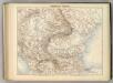
Hongrie et Turquie.
1 : 2400000 Jouvet et Cie.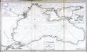
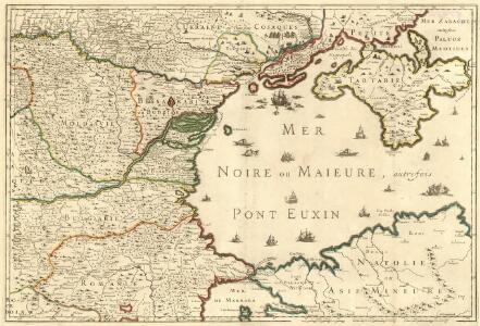
Carte réduite de la mer noire
1 Karte : Kupferdruck ; 51 x 92 cm Clerc; Dupuis Froullé
Danubii fluminis (hic ab urbe Belgrado, per Mare Nigrum usq Constantinopolim defluentis exhibiti) pars infima, in qua Transylvania, Walachia, Moldavia, Bulgaria, Servia, Romania et Bessarabia cum vicinis regionibus ostenduntur
Balkanhalbinsel, Donau, Flusslauf Homann, Johann Baptist
Ice Chart Black Sea, March, April.
U.S. Navy
Walachia Servia, Bulgaria, Romania [Karte], in: Gerardi Mercatoris et I. Hondii Newer Atlas, oder, Grosses Weltbuch, Bd. 1, S. 355.
1 Karte aus Atlas Mercator, Gerhard und Hondius, Jodocus Jansson, Jan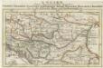
Ungarn
1 : 6500000 Mollova mapová sbírka Bodenehr, Gabriel Bodenehr, Gabriel
Ice Chart Black Sea, November, December.
U.S. Navy

Danubii Fluminis Pars Infima
1 : 2000000 Mollova mapová sbírka Haupt, Gottfried Jacob Haupt, Gottfried Jacob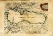
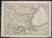
Mer noire ou mer maievre
1 Karte : Kupferdruck ; 18 x 24 cm Sanson s.n.
Mer noire ou mer maievre / par N. Sanson le fils geographe du roy
1 : 6900000 1 Karte : Kupferdruck ; 18 x 24 cm Sanson, Nicolas [chez l'Auteur]
Nova et Accurata Regni Hungariae Tabula, ad Usum Serenissimi Burgundiae Ducis
1 : 2500000 Mollova mapová sbírka Delisle, Guillaume Covens, Johannes I
WALACHIA | SERVIA, BVLGA- | RIA, ROMANIA
Per Gerardum Mercatorem Guiljelmus Blaeu excudebat
Walachia Servia, Bulgaria, Romania [Karte], in: Gerardi Mercatoris Atlas, sive, Cosmographicae meditationes de fabrica mundi et fabricati figura, S. 481.
1 Karte aus Atlas Mercator, Gerhard Montanus, Petrus