Maps of Netherlands

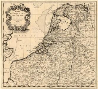
Carte des Provinces Unies des Pays Bas
1 : 1000000 Mollova mapová sbírka Chatelain, Zacharias Chatelain, Zacharias II
XVII PROVINCIAE BELGII accurate delineatae
Belgie
Les provinces apellées Pais-Bas, connues sous les noms de Flandre et de Hollande, divisée suivant quelles sont possedées aujourdhuy par les Roys de France et d'Espange et les Etats-Géneraux des Provinces Unies
1 : 800000 par N. de Fer... P. Starckman sculp. A Paris : se vend chez Danet ...
Carte des XVII. Provinces des Pays Bas
1 : 640000 Mollova mapová sbírka Inselin, Charles Jaillot, Alexis Hubert
Tableau des XVII Provinces des Pays Bas
Mollova mapová sbírka Husson, Pieter Husson, Pierre
Tafel Van de XVII Nederlandze Provincien
Mollova mapová sbírka Specht, Caspar
Niederlande, Belgien.
1 : 1470000 Flemming, Carl
Holland and Belgium.
1 : 1300000 Colton, G.W.
NOVA XVII PROVINCIARVM Germaniae Inferioris tabula, Leonis effigie, accurate delineata
1 : 100000 Belgie Visscher, Claes Jansz. bij Claes Ianß Visscher
Belgium & Holland.
1 : 1000000 John Bartholomew and Son
Belgique, Hollande.
1 : 1000000 Lapie, M. (Pierre), 1779-1850
Les Provinces Apellées Pais Bas Connues Sous Les Noms De Flandre Et De Hollande
1 : 880000 Mollova mapová sbírka Fer, Nicolas de Starckman, P. Fer, Nicolas de
Novissima et accuratissima XVII provinciarum Germaniae inferioris tabula
1 : 960000 Belgie Danckerts, Justus Munter, Johan ex officina Iusti Danckers
Carte du Royaume des Pays-Bas.
1 : 1360000 Vivien de St Martin, L.
Hollanda
[Giralomo Porro] [Venetië] : Simon Galignani ; Giralomo Porro]
Holland & Belgium.
1 : 950400 Fullarton, A. & Co.
Germaniae Inferioris XVII provinciarum accuratissima tabula / nuperrime edita per Nicolaum Visscher
1 : 950000 Annotatie: Met privilege; Met opdracht aan Theodorus Munter; Annotatie geografische gegevens: West boven Visscher, Nicolaes (1649-1702) [Amsterdam : N. Visscher]
De groote Nederlandse stedenwyzer, vertoonende met een opslag des oogs, de afgelegentheden tussen 108 steden der XVII. provintien, of Beantwoording op 5786 vragen, hoe veel uuren gaans de eene plaats van den ander is gelegen = La grande echelle des Pais-Bas, qui montre du premier coup d’oeil, la distence de 108 villes, des XVII. provinces, ou Reponce sur 5786. demandes, pour savoir de quelle distence une ville est eloignée de l’autre
te samen gesteld en int ligt gegeeven door Jan de Lat kaart en boekverkoper tot Deventer. Deventer : Jan de Lat
Nova XVII provinciarvm inferioris Germaniae descriptio
1 : 902400 Belgie Wit, Frederick de Dam Inde Witte pas-Caart
Postkarte von dem Vereinigten Niederlanden
Belgie Stenger, Johann im von Reillyschen Landkarten und Kunstwerke Verschleiss Komptoir
Niederlande u. Belgien.
1 : 1050000 Stein, Christ. Gottfr. Dan.
Novissima et accuratissima XVII provinciarum Germaniae Inferioris delineatio / A. Deur sculpsit
1 : 900000 Annotatie: Oorspr. verschenen in: Atlas contractus ... - Amstelaedami : ex officina Nicolai Visscher, [1656-1677]; Origineel is Blad 34 in atlas factice; Annotatie geografische gegevens: West boven Deur, Abraham [Amsterdam : ex officina Nicolai Visscher]
Holland and Belgium.
1 : 1290000 Colton, G.W.
Germaniae Inferioris XVII Provinciarum accuratissima tabula
1 : 940000 nuperrime edita per Nicolaum Visscher. [Amsterdam] : nunc apud Petrum Schenk Jun.
The Kingdom of the Netherlands
1 : 1495000 Belgie Walker, C. Baldwin & Gradock

Nieuwe kaart van de XVII Nederlandsche Provincien : waar in aangewezen worden de landen door den Koning van Vrankryk geconquesteerd als mede die van het Huis van Oostenryk, van den Koning van Pruisen en den Staat der Vereenigde Nederlanden, alles volgens het laatste tractaat van Barriere
1 : 850000 uitgege[ve]n door Reinier en Josua Ottens te Amsterdam. Te Amsterdam : Reinier en Josua Ottens
Novissima et accuratissima XVII provinciarum Germaniae inferioris delineatio
1 : 897000 Belgie Visscher, Nicolaes Jansz. ex officina Nicolai Visscher
Belgique, Hollande, Limbourg, Luxembourg.
1 : 1000000 Picquet, C.