Maps of Aargau

Per Inclyti Circuli Suevici Supremorum Ordinum :
1 : 160000 Mollova mapová sbírka Pfeffel, Johann Andreas Homann, Johann Baptista - dědici
Landtaflen
1 Atlas [von Johannes Stumpf] Christoffel Froschower, Zürych
Per Inclyti Circuli Suevici Supremorum Ordinum :
1 : 160000 Mollova mapová sbírka Pfeffel, Johann Andreas Pfeffel, Johann Andreas I.
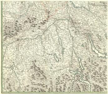
Zvrichgow et Basiliensis provincia
1 Karte : Kupferdruck ; 37 x 48 cm Janssonius; Broeck apud Johannem Janssonium
Zvrichgow et Basiliensis provincia
1 Karte : Kupferdruck ; 37 x 48 cm Valck; Schenk; Broeck apud G. Valk et P. Schenk
Zvrichgow et Basiliensis provincia
1 Karte : Kupferdruck ; 37 x 48 cm Blaeu Willem Janszoon Blaeu
Zvrichgow et Basiliensis provincia
1 Karte : Kupferdruck ; 36 x 48 cm Mercator; Blaeu s.n.
[Zurichgow, et Basiliensis provincia]
1 Karte : Kupferdruck ; 34 x 46 cm Mercator; Hondius Henricus Hondius
[Zurichgow, et Basiliensis provincia]
1 Karte : Kupferdruck ; 34 x 45 cm Mercator s.n.
[Zurichgow, et Basiliensis provincia]
1 : 250000 1 Karte per Gerardum Mercatorem [sumptibus & typis aeneis Iudoci Hondij], [Amsterodami]
Geographica Sueviæ universæ descriptio, 5
1 Blatt : Homännische Erben
Zurichou [i.e. Zürichgau]
1 : 650000 1 Karte [von Jodocus Hondius] [excusum in aedibus Iudoci Hondij], [Amsterodami]
[Zurichgow, et Basiliensis provincia]
1 : 250000 1 Karte per Gerardum Mercatorem [Mercator], [Duisburg]
Zurichgow et Basiliensis provincia
1 : 300000 1 Karte [apud Iohannem et Cornelium Blaeu], [Amsterdam]
[Zurichgow, et Basiliensis provincia]
1 : 250000 1 Karte per Gerardum Mercatorem [Mercator], [Duisburg]
Schulwandkarte zur Geschichte der Schweiz
1 : 180000 Nordblatt Oechsli, Wilhelm ; Baldamus, Alfred Kartograph. Verlagsanstalt von Georg Lang
Zurichgow et Basiliensis provincia
1 : 300000 1 Karte A. van den Broeck fecit apud Johannem Janssonium, Amstelodami
Schulwandkarte zur Geschichte der Schweiz
1 : 180000 1 Karte auf 6 Bl. bearbeitet v. W. Oechsli u. A. Baldamus ; gezeichnet von Ed. Gaebler Kartograph. Verlagsanstalt von Georg Lang, Leipzig
Karte mit Teilen der Ost- und der Innerschweiz
Originaltitel: Le canton de Zurich. Möglicherweise: Bertius, Petrus (1565-1629), Geograf
Reisekarte der Schweiz
1 : 500000 1 Atlas (1, 6 Bl.) gezeichnet von H. Keller und gestochen von J. Scheurmann = Carte routière de la Suisse / dessinée par H. Keller et gravée par J. Scheurmann bey Fuessli und Comp., Zürich
[Keller's Reisekarte der Schweiz]
1 : 500000 1 Karte auf 6 Bl. gezeichnet v. H. Keller ; gest. v. J.J. Scheurmann [Keller], Zürich
Karte des Kantons Aargau
1 : 250000 1 Karte J. Wurster & Comp., Winterthur
Zürichgau und Baselland
Originaltitel: Zurichgow et Basiliensis Provincia. Van den Broeck, A.
Carte de la Suisse avec les plans des cheflieux des 22 cantons
1 : 200000 1 Karte auf 8 Bl. dessinée et publié par Henri Keller ; Lithogr. von J. Schweizer = Charte der Schweiz mit den Grundrissen der Hauptorte der 22 Cantone Keller, Zürich
Neue und exacte geograph. Tabell von der Statt Zürich Gebiett
1 : 600000 1 Karte cura Ioh. Hofmeisteri ; Tobias Lobeck deli. et sculp.
Tschudi's Touristenkarte der Centralschweiz
1 : 250000 1 Karte Stich u. Druck: Wurster, Randegger Scheitlin & Zollikofer, St. Gallen
<<Die>> Cantone Solothurn und Basel
1 : 275000 1 Karte gest. v. J.J. Scheurmann Orell Füssli, Zürich
Wandkarte der Schweiz
1 : 200000 1 Karte auf 8 Blättern J.M. Ziegler Wurster, Winterthur
[Zürich, Basel] [Karte], in: Gerardi Mercatoris Atlas, sive, Cosmographicae meditationes de fabrica mundi et fabricati figura, S. 264.
1 Karte aus Atlas Mercator, Gerhard Montanus, Petrus