Maps of Douai
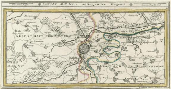
Douay Mitt Nahe anliegender Gegend.
1 : 130000 Mollova mapová sbírka Bodenehr, Gabriel Bodenehr, Gabriel
Carte Tres particuliere des Environs de Douay ou L'on voit les Lignes de Circonvalation, Comme aussy l'Innondation faite par la Scarpe
1 : 93000 Douai (Francie) Fricx, Eugene Henry Harrewyn, Jacques chez Eugene Henry Fricx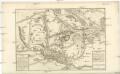
Carte Tres particuliere des Environs de Douay ou L'on voit les Lignes de Circonvalation, Comme aussy l'Innondation faite par la Scarpe
1 : 93000 Douai (Francie) Fricx, Eugene Henry Harrewyn, Jacques chez Eugene Henry Fricx
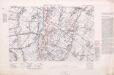
France Sheet 36c. 3rd ed. 'For Indian Contingent'
1 : 40000 First World War map of France Sheet 36c. 3rd ed. 'For Indian Contingent'. Place names in English and Hindi. War Office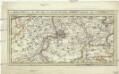
Ryssel oder Lille mitt nahe anliegender Gegend
1 : 132000 Lille (Francie) Bodenehr, Gabriel G. Bodenehr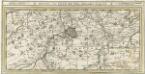
Ryssel oder Lille Mitt Nahe anliegender Gegend.
1 : 130000 Mollova mapová sbírka Bodenehr, Gabriel Bodenehr, Gabriel
Plan tres exact des environs de Douay, Lens, Ecluse, et Arleux
1 Karte : Kupferdruck ; 38 x 50 cm Rotterdam by Pieter Rotterdam boekverkoper op de Vygendam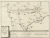
Plan Du Champ de Battaille pour l'Armée des Hauts-Allies entre Vitry et Montigny le 28. May 1710
Mollova mapová sbírka Fricx, Eugène Henry Fricx, Eugené Henry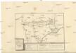
PLAN Du Champ de Battaille pour l'Armée des Hauts-Allies entre Vitry et Montigny le 28. May 1710
Fricx, Eugene Henry Eugene Henry Fricx
Zur Belagerung von Lille
Lille (Francie) Fricx, Eugene Henry K.k. Generalstabes
Plan de la ville de Lille : investie par les Haut-Allies sous le commandement de S. A. le Prince Eugene de Savoye le 13. Aoust et prize le 8. Octobre 1708, où l'on void comment et par où elle a esté attaquée
1 : 25000 dessinné sur le lieu avec la derniere exactitude par Monsr. Brüchman, capitaine ...
Doway a strong city in the earldom of Flanders in the Low countries : subject fo the french : plan of the city of Doway / J. Basire sculp
Basire, J.
DVACVM; Vulgo | DOUAY
[Amsterdam : Joan Blaeu]
Lilla in Fiandra
Lille (Francie) Gualdo Priorato, Galeazzo Hacque, Johann Baptist Gio. Battista Hacque
Lilla in Fiandra
Lille (Francie) Gualdo Priorato, Galeazzo Hacque, Johann Baptist Gio. Battista Hacque
INSVLA, | Vulgo | LILLE, | Belgice | RIISSEL
[Amsterdam : Joan Blaeu]
Plan parcellaire de la commune de Hertain : avec les mutations
1 : 5000 Royal Library of Belgium Map Room Popp, Philippe Christian (1805-1879) Popp, Philippe Christian (1805-1879)
Plan parcellaire de la commune de Lamain : avec les mutations
1 : 5000 Royal Library of Belgium Map Room Popp, Philippe Christian (1805-1879) Popp, Philippe Christian (1805-1879)
Plan de la citadelle de Lille: laquelle, apres que la ville fut prise le 22. Octobre, on a aussi commencé d'attaquer sous le commandement de S. A. Le Prince Eugene de Savoye dès le 29. et ainsi continué ... iusques au 8. Decembre 1708 ...
1 : 4450 par le Sieur Brüchman capitaine ...
PLAN DE LA CITADELLE DE LILLE
1 : 4500 Lille (Francie) Fricx, Eugene Henry Brüchman chez Eugene Henry Fricx
Plan des attaques de la ville de Lille commencées sous le commandement de S.A.S. le prince Eugene de Savoye le 22. aoust et finies le 22. octobre 1708, jour de la reddition
1 : 4500 Lille (Francie) Fricx, Eugene Henry Brüchman chez Eugene Henry Fricx
Développement du village de Templeuve : à l'échelle d'un à 1250
1 : 1250 Royal Library of Belgium Map Room Popp, Philippe Christian (1805-1879) Popp, Philippe Christian (1805-1879)
Das belaegerte Kyssel
Lille (Francie) bey Johann Jonathan Felßeckern sel. Erben
Lille. 1917.
1 : 20000 First World War map. Lille. 1917. Shows all bridges. War Office
Plan du siège de Lille avec des environs [1708]
1 : 17000 P. v. Cal fecit
Plan parcellaire de la commune de Esplechin : avec les mutations
1 : 5000 Royal Library of Belgium Map Room Popp, Philippe Christian (1805-1879) Popp, Philippe Christian (1805-1879)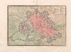
A colored plan of "Lille
A colored manuscript plan of Lille, France; "drawn about 1720, on a scale of 120 toises to an inch."
Plan de la ville de Lille investie par les Haut-Allies sous le commandement de S.A. le prince Eugene de Savoye le 13. aoust et prize le 8. octobre 1708 ou l'on void comment et par ou elle a esté attaquée
1 : 24000 Lille (Francie) Fricx, Eugene Henry Brüchman chez Eugene Henry Fricx
Plan de la ville et citadelle de Lille: la ville fut attaquée par les Alliés sous le commandement de S. A. Le Prince Eugene de Savoye le 22. Aoust, & se rendit le 22. Octobre 1708 : l'ennemy s'estant retiré par accord dans la citadelle, elle fut pareil [...]
1 : 10000 par Mons.r. Brüchman