Maps of Veurne
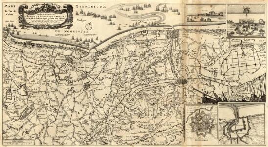
Perfecte Kaerte van t'Berger en Broucborger Ambacht, mitsgaders de Wateringen ende de Vier Dycken
Mollova mapová sbírka Visscher, Nicolaes Schenk, Peter II.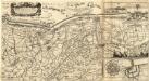
Perfecte Kaerte van t'Berger en Broucborger Ambacht, mitsgaders de Wateringen ende de Vier Dycken
1 : 90000 Mollova mapová sbírka Visscher, Claes Jansz. Visscher, Claes Janszoon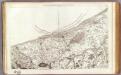
6 Dunkerque.
1 : 86400 Cassini family; Cassini, Cesar-Francois, 1714-1784
Flandriae pars occidentalis
1 : 185000 Belgie Hondius, Henricus sumptibus Henrici Hondii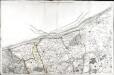
[Dunkerque]
1 Blatt : 60 x 91 cm s.n.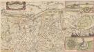
Perfecte Kaerte, van t' Berger En Broucborger Ambacht, mitsgaders de Wateringen ende de Vier Dycken [Karte], in: Novus atlas absolutissimus, Bd. 3, S. 118.
1 Karte aus Atlas Janssonius Offizin
Pascaert vande Custe van Vlaenderen, van Walcheren tot Cales en Bouloigne im Vranckrijck. [Karte], in: Gerardi Mercatoris et I. Hondii Newer Atlas, oder, Grosses Weltbuch, Bd. 1, S. 419.
1 Karte aus Atlas Mercator, Gerhard und Hondius, Jodocus Jansson, Jan
Carte particuliere des environs de Dunkerque, Bergues, Furnes, Gravelines, Calais, et autres
1 : 110000 Belgie Fricx, Eugene Henry Harrewyn, Jacques chez Eugene Henry Fricx
Carte particuliere des environs de Dunkerque, Bergues, Furnes, Gravelines, Calais, et autres
1 Karte : Kupferdruck ; 40 x 55 cm Fricx; Harrewijn chez Eugene Henry Fricx ruë de la Madelen
Flandriae Comitatus pars occidentalis
1 : 133000 Mollova mapová sbírka Visscher, Nicolaes Schenk, Peter II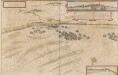
Pascaert vande Custe van Vlaenderen, van Walcheren tot Cales en Bouloigne im Vranckrijck. [Karte, Duynkercken] , in: Novus atlas absolutissimus, Bd. 3, S. 112.
1 Karte aus Atlas Janssonius Offizin
Carte Partic. des environs de Dunkerque, Bergues, Furnes, Gravelines, Calais, et Autres
1 : 250000 Mollova mapová sbírka Seutter, Matthäus Seutter, Matthäus
VI, uit: Carte chorographique des Pays-Bas Autrichiens / ... par le Comte de Ferraris ; gravée par L.A. Dupuis
1 : 86400 Annotatie: Lit.: Les militaires et la cartographie des Pays-Bas méridionaux et de la Principauté de Liège à la fin du XVIIe et au XVIII siècle / Claire Lemoine-Isabeau. - Bruxelles, 1984, p. 206-212; La cartographie au XVIIIe siècle et l'oeuvre du Comte de Ferraris (1726-1814) : colloque international, Spa, 8-11 sept. 1976. - Bruxelles, 1978; Met opdracht aan keizer Joseph II (bl.XVI); Met plattegrond van Brussel (bl. XXI), overzichtskaart (bl. XXII) en bladwijzer (bl. XXIII); Ontbreekt: bl. I-III en XXI; Voor aanwezige bladen zie overzichtsblad Ferraris, Johann Joseph; Dupuis, L. A. [S.l. : s.n.]
Perfecte kaerte van t' Berger en Broucborger Ambacht, mitsgaders de Wateringen ende vier dycken
1 : 60000 nieulijkx verb. en uytg. door Nicolaus Visscher [Amsterdam] : nunc apud Petrum Schenk Junior
TERRITORIVM | BERGENSE.
[Amsterdam : Joan Blaeu]
Carte Particuliere des environs de Dunkerque, Bergues, Furnes, Gravelines, Calais, et Autres
1 : 116600 Mollova mapová sbírka Fricx, Eugène Henry Harrewyn, Jacques Fricx, Eugené Henry
VI ; 2.H., uit: Carte chorographique des Pays-Bas Autrichiens / ... par le Comte de Ferraris ; gravée par L.A. Dupuis
1 : 86400 Annotatie: Bladen linksboven genummerd met Romeinse cijfers, rechtsboven met een cijfer en een letter; Met opdracht aan keizer Joseph II (bl.XVI); Met plattegrond van Brussel (bl. XXI), overzichtskaart (bl. XXII) en bladwijzer (bl. XXIII); Annotatie geografische gegevens: Schaalstokken: Echelle de Toises ou de Lieues communes de France; Echelle de Verges ou de Lieues de Brabant; Echelle de Milles d'Allemagne (bl. XVII); Echelle de Mètres; In de hoeken lengte- en breedtematen T.M.e en T.P.e Joseph-Jean François Ferraris Comte de 1726-1814; L.A. Dupuis [S.l. : s.n.]
Capitainerie garde-coste de Dunquerque et partie de celle de Sangatte
1 Karte : 22 x 31 cm de Fer
CASTELLANIA | FURNENSIS
[Amsterdam : Joan Blaeu]
[Küste vor Duynkercken] [Karte], in: Novus Atlas, das ist, Weltbeschreibung, Bd. 1, S. 365.
1 Karte aus Atlas Blaeu, Joan Blaeu, Willem Janszoon
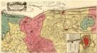
Afbeeldinge vande vermaerde seehaven ende stadt van Duynkercken met der omliggende plaetsen sanden ende droochten [Karte], in: Theatrum orbis terrarum, sive, Atlas novus, Bd. 1, S. 378.
1 Karte aus Atlas Blaeu, Joan Blaeu, Willem Janszoon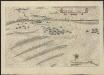
Afbeeldinge vande vermaerde seeha- | ven ende stadt van Duynkercken met | der omliggende plaetsen sanden ende | droochten [=] Pourtraict de la fameuse ville | et havre de Duynckercke et | places voisines, sables etc.
afgeteeckent door Capiteijn | Pieter Codde van Enchuysen [Amsterdam : Joan Blaeu]
Gegend von Duykercken Furnes und Nieuport
1 : 150000 Mollova mapová sbírka Merian, Matthaeus Merian, Matthäus - dědici
De kust van Vlaanderen van Grevelingen tot Calais int groot
France Gerard van Keulen
Le Gouvernement De Calais & Pais Reconquis. [Karte], in: Novus atlas absolutissimus, Bd. 4, S. 53.
1 Karte aus Atlas Janssonius Offizin
LE GOUVERNEMENT | DE CALAIS | & PAYS RECONQUIS.
[Amsterdam : Joan Blaeu]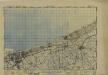
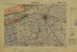
France 1:50,000, Dunkerque
Sheet 29 from the 115-sheet map series: France and Belgium 1 : 50,000. G.S.G.S. No. 4040. Compiled and drawn by O.S. Revised 1939-44. [London] : War Office
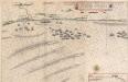
The platt of the Lowe Countrye att Calleys
This is a map of Calais, Franceand the surrounding area from the sea. It was drawn in October 1545 by Thomas Petit. Although not formally appointed as Surveyor of the works at Calais until February 1546 Petit was in the post by October 1545 after his predecessor John Burgate died, probably of plague. The map shows the environs of Calais, recording waterways and fortifications of the area. The town of Calais is shown with the castle to the right. The Rysebank tower with its distinctive triangular bastion is also depicted. The enlargement of the fort at Rysebank was one of the main areas of work during the building programme of the 1540’s. Newneham bridge is also shown. This controlled the causeway across the marches to the west of Calais and its sluice gates could be used to dam the Hammes River and flood the low country around the town .It was therefore a vital part of the defences. Petit, Thomas