Maps of Nord

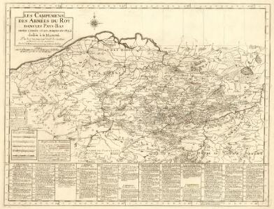
Les Campemens des armées du Roy dans les Pays-Bas
1 : 855000 Mollova mapová sbírka Moullart-Sanson, Pierre
Les Campemens des armées du Roy dans les Pays-Bas
1 : 855000 Mollova mapová sbírka Moullart-Sanson, Pierre
Les Campemens des armées du Roy dans les Pays-Bas
1 : 855000 Mollova mapová sbírka Moullart-Sanson, Pierre
Les Campemens des armées du Roy dans les Pays-Bas
1 : 855000 Mollova mapová sbírka Moullart-Sanson, Pierre
Les provinces des Pais Bas Autrichiens
Belgie Seutter, Matthäus par Matthieu Seutter
Netherlands (south)
1 : 250000 Kitchin, Thomas; Robert Laurie & James Whittle
Carte routiere du théatre de la guerre, contenant la Flandre, partie du Brabant et du Comte de Namur : dressée d'après la grande carte de Ferraris ...
1 : 250000 Annotatie: Het impressum vermeldt als jaar van uitgave: l'an 2eme de la République Française Paris : Basset
Le Theatre de Bellone :
Mollova mapová sbírka Schenk, Pieter Braakman, Adriaan
Tableau indicatif du chemin de fer, 1837 ; Carte des chemins de fer de la Belgique
1 : 1150000 Bruxelles : Etablissement Géographique
Composite: Carte de France.
1 : 86400 Cassini family; Cassini, Cesar-Francois, 1714-1784
Composite 1: Carte de France.
1 : 86400 Cassini family; Cassini, Cesar-Francois, 1714-1784

Flandriae Comitatus Accuratissima Descriptio [Karte], in: Novus atlas absolutissimus, Bd. 3, S. 109.
1 Karte aus Atlas Janssonius Offizin
Comtés d'Artois et de Hainaut
1 Karte : Kupferdruck ; 32 x 57 cm Duval chez l'autheur prés le Palais sur le quay de l'Orloge au coin de la ruë de Harlay
Comitatus Flandriae tabula
1 : 284000 Flandry Wit, Frederick de Deur, Abraham F. de Wit
Comitatus Flandriae tabula
1 : 280000 Flandry Wit, Frederick de Deur, Abraham Frederico de Wit
Novissima Flandriae comitatus tabula
1 : 330000 1 Karte : Kupferdruck ; 49 x 56 cm Danckerts, Theodorus [Danckerts]
Map showing Railway system and Military organization of the country in rear of the enemy’s lines (in France and Belgium)
1 : 250000 Map showing Railway system and Military organization of the country in rear of the enemy’s lines (in France and Belgium) War Office
Gouvernement de Flandre
1 Karte : Kupferdruck ; 31 x 42 cm Mentelle; Tardieu; Dubuisson Mentelle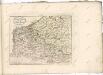

Flandriae Comitatus accuratissima descriptio
1 : 320000 edita per Nicolaum Visscher. 't Amsteldam : by Nicolaes Visscher
Flandriae comitatus
1 : 300000 Flandry Visscher, Nicolaes Jansz. Gouwen, Giliam van der apud Petrum Schenk junior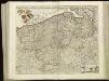
[105][108] Comitatus Flandriae tabula, uit: Atlas sive Descriptio terrarum orbis
Annotatie: Gedigitaliseerde versie. Amsterdam. Heiloo : Picturae (vervaardiger), 2015. tiff-bestand. Gedigitaliseerd: 07-01-2015; Origineel: Universiteitsbibliotheek Vrije Universiteit (XL.05127.-) ; Netherlands; Titelpagina ontbreekt Wit, Frederik de Amsterdam : Frederick de Wit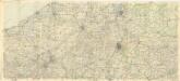
Carte Michelin de la Belgique

Carte du département du Nord
1 Karte : Kupferdruck ; 22 x 32 cm, Bildgrösse 32 x 42 cm Brion de la Tour; Desnos Desnos rue St. Jacques au globe
Flandriae Comitatus Descriptio. [Karte] [Walcheren. Borsele. Suitbeverlandt.] [Nebenkarte], in: Theatrum orbis terrarum, S. 186.
1 Karte aus Atlas Ortelius, Abraham Vrients, Jan Baptista
Flandria maximus et pulcherrimus Europae comitatus
1 : 310000 Flandry Seutter, Matthäus
Flandria. [Karte], in: Theatrum orbis terrarum, S. 48.
1 Karte aus Atlas Ortelius, Abraham
Eisenbahn-Nachträge zu Kiepert's Handatlas
Neuer Handatlas über alle Theile der Erde Kiepert, Heinrich Verlag von Dietrich Reimer