Maps of Germany

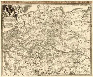
Postarum seu Veredariorum Stationes per Germaniam et Provincias adiacentes
1 : 2500000 Mollova mapová sbírka Fricx, Eugène Henry Paar, Carl Joseph von Fricx, Eugené Henry
Reise Charte durch Deutschland
1 : 7400000 Mollova mapová sbírka Schreiber, Johann Georg Schreiber, Johann Georg
Neueste Post Karte von Deutschland und dessen angrenzenden Laendern
Evropa střední Walch, Johann Ioh. Walch
Neueste Post Karte von Deutschland und dessen angrenzenden Laendern
Evropa střední Walch, Johann bei Joh. Walch
Neueste Post Karte von Deutschland und dessen angrenzenden Laendern
Evropa střední Knittel, Joh. Ernst Campe, Friedrich Friedrich Campe
Carte exacte des Postes et Routes de l'Empire d'Allemagne
1 : 2500000 Mollova mapová sbírka Delisle, Guillaume Covens, Johannes I
Post Karte durch ganz Deutschland
Evropa střední Walch, Johann Joh. Walch
Post Charte von Teutschland
1 : 1750000 Evropa střední Güssefeld, Franz L. Geograph. Institut
Post Karte durch ganz Deutschland
1 : 2100000 Evropa střední Walch, Johann bey Joh. Walch
Mappa chorographica Omnivm Episcopatvvm Germaniae ab AC. MD ad MDCCLX existentium
1 : 2600000 Mollova mapová sbírka Hartzheim, Josephus Homann, Johann Baptista - dědici
Extract einer General-Post-Chartre von allen Pos routen durch gantz Teutschland und dessen gewöhnliche X. Creisse in benachbarte Länder
1 : 5800000 Mollova mapová sbírka Weigel, Christoph Weigel, Christoph I.
Postarum seu Veredariorum Stationes per Germaniam et Provincias Adiacentes
1 : 2500000 Mollova mapová sbírka Schenk, Pieter Schenk, Peter I

Germaniae Veteris typus
1 : 3600000 Mollova mapová sbírka Ortelius, Abraham
Germania secundum observationes recentissimas in suos circulos divisa
1 : 2313000 Německo Walch, Johann Ioanes Walch
Germania secundum observationes recentissimas in suos circulos divisa
1 : 2313000 Německo Walch, Johann Ioanes Walch
Karte von Central-Europa bis Paris, Mailand, Triest, Pesth, Krakau, Königsberg, Schleswig
1 : 1800000 Budapešť (Maďarsko) Justus Perthes
Neue Post-Karte von Teutschland zum altgemeinen Postbuch von Teutschland
1 : 2000000 Diez, Franz Maximilian 1761-1851 Berlin : C. Jack
Die West See auch Das Teutsche Meer von den Hollaendern aber die Nordsee geheissen
1 : 500000 Mollova mapová sbírka Bodenehr, Gabriel Bodenehr, Gabriel
Deutschland nach den letzten Friedenschlüssen
1 : 3600000 Evropa střední Mollo, Tranquillo bey Tranquillo Mollo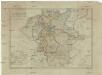
Deutschland nach den letzten Friedenschlüssen
1 : 3600000 Evropa střední Mollo, Tranquillo Tranquillo Mollo
Regni Germaniae delineatio, secundum X. Circulorum divisionem veram suam figuram hodiernos circulorum et regni totius exacte referens
1 : 7900000 Mollova mapová sbírka Franz, Johann Michael Homann, Johann Baptista - dědici
Karte der fahrbaren oder im Bau begriffenen und der ernstlich projectirten Eisenbahnen in Deutschland, Belgien und Holland, so wie desgleichen einiger in Frankreich, in der Schweiz, in Italien und in Polen
1 : 2470000 Belgie Müller, Emil bey Hoffmann & Campe
[Recto], uit: Post- und Eisenbahn-Karte von Deutschland, den Niederlanden, Belgien und der Schweiz / bearb. nach L. Friedrich's Post-, Eisenbahn- & Reisekarte von Mittel-Europa
1 : 1800000 Annotatie: Ondertitel op omslag: Bis Calais & Paris, Rügen & Königsberg, Krakau & Pesth, Venedig & Grenoble Gotha : Perthes
Neu vermehrte Post Charte durch gantz Teutschland nach Italien, Franckreich, Niederland, Preußen, Polen, und Ungarn &c.

Deutschland und anliegende Länder zur Übersicht, d Hauptstr. u. Entfernungen zw. Paris, Mailand, Warschau u. Königsberg
1 : 3800000 Evropa střední Stieler, Adolf Justus Perthes
S. Imperium Romano-Germanicum oder Teutschland mit seinen Angräntzenden Königreichen und Provincien
1 : 2500000 Mollova mapová sbírka Visscher, Nicolaes Jansz. Hogeboom, Andries Schenk, Peter II
S. Imperium Romano-Germanicum oder Teutschland mit seinen Angräntzenden Königreichen und Provincien
1 : 2500000 Mollova mapová sbírka Schenk, Pieter Hogeboom, Andries Schenk, Peter II
S. Imperium Romano-Germanicum oder Teutschland mit seinen Angräntzenden Königreichen und Provincien
1 : 2500000 Mollova mapová sbírka Schenk, Pieter Hogeboom, Andries Schenk, Peter II