Maps of Southeast

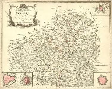
Carte Particuliere de la Moravie divisée en six cercles
1 : 650000 Mollova mapová sbírka Le Rouge, Georges-Louis Le Rouge, Georges-Louis
Marchionatus Moravia
1 : 1525000 Mollova mapová sbírka Seutter, Matthäus Lotter, Tobias Conrad Seutter, Matthäus
Das Marckgraffthum Maehren mit seinen abgetheilten Creissen
1 : 2050000 Mollova mapová sbírka Weigel, Christoph Weigel, Christoph I.
Die Markgrafschaft Mähren nebst dem Herzogthum Schlesien
1 : 750000 Lázně Jeseník (Česko) Berghaus, Heinrich Karl Wilhelm Berghaus, Hermann Justus Perthes
Das Marckgraffthum Maehren mit seinen abgetheilten Creissen
1 : 2100000 Mollova mapová sbírka
Tabula generalis marchionatus Moraviæ in sex circulos divisæ
1 Karte : Kupferdruck ; 47 x 57 cm Homann; Müller Johann Baptist Homann
Tabula generalis marchionatus Moraviæ in sex circulos divisæ
1 Karte : Kupferdruck ; 47 x 57 cm Homann; Müller Johann Baptist Homann
Tabula generalis marchionatus Moraviæ in sex circulos divisæ
1 Karte : Kupferdruck ; 47 x 57 cm Homann; Müller Johann Baptist Homann
Tabula generalis marchionatus Moraviae in sex circulos divisae / quos mandato caesareo accurate emen
1 : 640000 1 Karte : Kupferdruck ; 47 x 57 cm Homann, Johann Baptist [Johann Baptist Homann]
Moravia Marchionatus in sex Circulos divisus juxta recentissimam dimensionem et accuratissimas Observationes
1 : 65000 Mollova mapová sbírka Seutter, Matthäus Seutter, Matthäus
Neue und Accurate general Land-Karten der gantzen Marggraffschafft Mähren :
1 : 540000 Mollova mapová sbírka Lidl, Johann Jakob Lidl, Joh. Jacob
Tabula Generalis marchionatus Moraviae in sex circulos divisa
1 : 645000 Mollova mapová sbírka Müller, Johann Christoph Homann, Johann Christoph
Tabula Generalis marchionatus Moraviae in sex circulos divisa
1 : 645000 Mollova mapová sbírka Müller, Johann Christoph Homann, Johann Baptista
Das Markgraftum Maehren mit der Aelteren und im Jahr 1783 abgeaenderten Eintheilung der Kreisen, auch Bezeichnung der Granze der Olmütz Dioeces in Schlesien
1 : 322000 Morava (Česko) Venuto, Jan Antonín Engelmann, J. W.
Das Markgraftum Maehren mit der Aelteren und im Jahr 1783 abgeaenderten Eintheilung der Kreisen, auch Bezeichnung der Granze der Olmütz Dioeces in Schlesien
1 : 322000 Morava (Česko) Venuto, Jan Antonín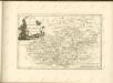

Mappa Geographica specialis Marchionatus Moraviae in sex Circulos divisae
1 : 660000 Mollova mapová sbírka Lotter, Tobias Conrad Lotter, Tobias Conrad
Kleine Land Karte des Marggrafthum Mähren für die Jungend in Bildern entworfen
Moravia-Silesia
1 : 750000 Morava (Česko)
Moravia-Silesia
1 : 750000 Morava (Česko)
Moravia-Silesia
1 : 750000 Morava (Česko)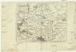
Moravia
1 : 931000 Morava (Česko) Keere, Pieter van den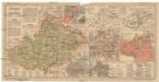
Morava a Slezsko
Morava (Česko) Salač, Klement Metzeroth, Carl B. Kočí
Příruční mapa markrabství Moravského a vévodství Slezského

Marchionatus Moravia
1 : 1600000 Morava (Česko) Seutter, Matthäus Lotter, Tobias Conrad Tobias Conrad Lotter
Carte générale du marquisat de Moravie
1 : 545000 Morava (Česko) Condet, Johannes chez Cóvens et Mortier
Handkarte der Markgrafschaft Mähren und des Herzogthumes Schlesien
1 : 750000 Brno (Česko) Schober, Karl vom K. u. k. militär-geograph. Institute
Tabula generalis Marchionatus Moraviae

Mappa geographica specialis marchionatus Moraviae in sex circulos divisae, ad notatis principaliorib[us] huj[us] marchion: cursibus publicis, ad meliorem praesentis belli intelligentiam
1 : 650000 cura et sumptibus Tobiae Conradi Lotter Matth. Albrecht Lotter, sculps. Aug. Vind : [Tobias Conrad Lotter]