Maps of okres Brno-venkov

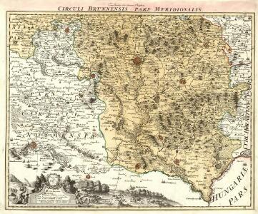
Circuli Brunnensis pars Meridionalis /
1 : 230000 Mollova mapová sbírka Müller, Johann Christoph Homann, Johann Baptista - dědici
[Marchionatus Moraviae circulus Brunnensis]
Brno-oblast jižní (Česko) Müller, Johann Christoph Homann, Johann Baptist Ioh. Baptista Homanno
[Marchionatus Moraviae circulus Brunnensis]
Brno-oblast jižní (Česko) Müller, Johann Christoph Homann, Johann Baptist Ioh. Baptista Homanno
[Marchionatus Moraviae circulus Brunnensis]
Brno-oblast jižní (Česko) Müller, Johann Christoph Homann, Johann Baptist Ioh. Baptista Homanno
[Marchionatus Moraviae circulus Brunnensis]
Brno-oblast jižní (Česko) Müller, Johann Christoph Homann, Johann Baptist Ioh. Baptista Homanno
Brno automapa okolí

Národnostní mapa Moravy

Národnostní mapa Moravy
1 : 150000 Morava jižní (Česko) Chytil, Alois nákladem Al. Chytila
Die Markgraftschaft Mähren
1 : 22000 Brno-oblast (Česko) Schenkl, Conrad Philipp Carl Winiker
Brünn
1 : 200000 Brno-oblast (Česko)
Normální mezinárodní letecká mapa.

[Brno a okolí]
Brno-oblast (Česko)
Generální mapa okresních hejtmanství
Soubor map politických okresů

Brunn.
from Spezialkarte der osterreichisch-ungarischen Monarchie.
Komunikační mapa země Moravskoslezské
1 : 100000 Znojmo (Česko : oblast) Morslez. zem. výbor
Umgebungen von Brünn
1 : 144000 K.K. Militärisches Geographisches Institut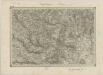
II. vojenské mapování 13
1 : 144000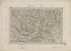
II. vojenské mapování 13
1 : 144000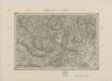
II. vojenské mapování 13
1 : 144000
Generální mapa okresních hejtmanství

Die Markgraftschaft Mähren
1 : 22000 Znojmo-oblast (Česko) Schenkl, Conrad Philipp Carl Winiker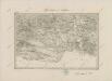
II. vojenské mapování 17
1 : 144000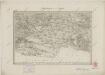
II. vojenské mapování 17
1 : 144000
Mapa okolí brněnského
1 : 150000 Brno-oblast (Česko) Líčka, Josef A. Píša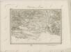
II. vojenské mapování 17
1 : 144000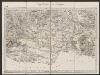
Umgebungen von Znaym
1 : 144000 K.K. Militärisches Geographisches Institut
Auspitz und Nikolsburg.
from Spezialkarte der osterreichisch-ungarischen Monarchie.
Mapa okolí brněnského