Maps of Zell am See

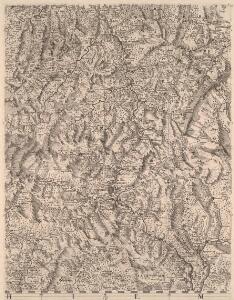
Tyrolis sub Felici Regimine Mariae Theresiae Rom. Imper. Avg. Chorographice Delineata ...
1 : 104000 Mollova mapová sbírka Mansfeld, Johann Ernst Mansfeld, Johann Ernest
Tyrolis sub Felici Regimine Mariae Theresiae Rom. Imper. Avg. Chorographice Delineata ...
1 : 104000 Mollova mapová sbírka Mansfeld, Johann Ernst Mansfeld, Johann Ernest
Tyrolis sub Felici Regimine Mariae Theresiae Rom. Imper. Avg. Chorographice Delineata ...
1 : 104000 Mollova mapová sbírka Mansfeld, Johann Ernst Mansfeld, Johann Ernest
Tyrolis sub Felici Regimine Mariae Theresiae Rom. Imper. Avg. Chorographice Delineata ...
1 : 104000 Mollova mapová sbírka Mansfeld, Johann Ernst Mansfeld, Johann Ernest
Salisburgensis jurisdictionis locorumque vicinorum vera descriptio
1 Karte : Kupferdruck ; 18 x 26 cm Quad; Nagel; Bussemacher; Secznagel Johannes Bussemacher
Carte topographique d'Allemagne contenant une partie de la Baviere, de l'eveché de Salzburg, de Tirol
1 Karte : Kupferdruck ; 46 x 63 cm Jaeger se vend chez l'auteur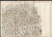
Carte du Tyrol
1 : 150000 Nordost-Blatt Anich, Peter par le Dépôt Général de la Guerre
Militair Karte von Süd-Deutschland in 20 Sectionen
1 : 400000 15. Section Coulon, Alois von A. von Coulon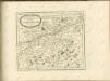

[Tirol]
Tyrolsko (Rakousko) Woerl Herder, B. B. Herder
Tyrolis sub Felici Regimine Mariae Theresiae Rom. Imper. Avg. Chorographice Delineata ...
1 : 104000 Mollova mapová sbírka Mansfeld, Johann Ernst Mansfeld, Johann Ernest
Tyrolis sub Felici Regimine Mariae Theresiae Rom. Imper. Avg. Chorographice Delineata ...
1 : 104000 Mollova mapová sbírka Mansfeld, Johann Ernst Mansfeld, Johann Ernest
189. Tegernsee, uit: Topographische Uebersichtskarte des Deutschen Reiches / herausgegeben v. d. Kartogr. Abt. d. Königl. Preuß. Landesaufnahme
1 : 200000 titelvariant: Topogr. Übersichtskarte des Deutschen Reiches; Annotatie: Titel boven bladen ook: Topogr. Übersichtskarte des Deutschen Reiches; Annotatie geografische gegevens: Op elk blad twee maatstokken: 10 Kilometer = 5,5 cm; 1 geogr. Meile = 3,6 cm; Legenda onder op elk blad Königlich Preußische Landesaufnahme. Kartographische Abtheilung [S.l : Königlich Preußische Landesaufnahme, Kartographische Abtheilung]
Zell 158, uit: Special-Karte von Mittel-Europa / nach amtlichen Quellen bearbeitet von W. Liebenow
1 : 300000 titelvariant: W. Liebenow's Mittel-Europa; Annotatie: Titel boven de bladen: W. Liebenow's Mittel-Europa Johannes Wilhelm Liebenow 1822-1897 Frankfurt a. M. : Ludwig Ravenstein
Innsbruck 157, uit: Special-Karte von Mittel-Europa / nach amtlichen Quellen bearbeitet von W. Liebenow
1 : 300000 titelvariant: W. Liebenow's Mittel-Europa; Annotatie: Titel boven de bladen: W. Liebenow's Mittel-Europa Johannes Wilhelm Liebenow 1822-1897 Frankfurt a. M. : Ludwig Ravenstein
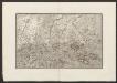
Pars VIII. sistit partem dicast.ii Monach: et Burchh: ex utraqué parte Oeni merid. versus, cum dÿnastia Burgrain, Hohen=Waldeck; archi=episc: Salisb: et finibus c: Tir
1 Karte : 54 x 52 cm Heinrich Ludwig Broenner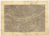
[Innsbruck a okolí]
1 : 144000 Innsbruck-oblast (Rakousko)
Tyrolis sub Felici Regimine Mariae Theresiae Rom. Imper. Avg. Chorographice Delineata ...
1 : 104000 Mollova mapová sbírka Mansfeld, Johann Ernst Mansfeld, Johann Ernest
[Innsbruck und Umgebung]
1 : 250000 Innsbruck (Rakousko : oblast) Wagner & Debes
Skikarte für das Gebiet von Krimml und des Großvenedigers
1 : 50000 Salcburské Alpy (Rakousko : pohoří) Kartographisches Institut
Rattenberg.
from Spezialkarte der osterreichisch-ungarischen Monarchie.
Kitzbuhel und Zell Am See.
from Spezialkarte der osterreichisch-ungarischen Monarchie.
Innsbruck und Achen-See.
from Spezialkarte der osterreichisch-ungarischen Monarchie.
Kufstein.
from Spezialkarte der osterreichisch-ungarischen Monarchie.
Lofer und St. Johann.
from Spezialkarte der osterreichisch-ungarischen Monarchie.
Achenkirch und Benedictbeuern.
from Spezialkarte der osterreichisch-ungarischen Monarchie.
Sistit Partem Dicast.ii Monach: et Burchh: ex utraqué Parte Oeni Merid. versus, cum Dÿnastia Burgrain, Hohen-Waldeck; Archi-Episc: Salisb: et finibus c: Tir
1 : 150000 Mollova mapová sbírka Buna, Wilhelm C. Broenner, Heinrich Ludwig
Umgebungskarte von Innsbruck
1 : 75000 Innsbruck (Rakousko : oblast) K. u. k. Militärgeographisches Institut