Maps of Trentino-Alto Adige/Südtirol

Tirol, Samt denen angrenzend- und einverleibten Ländern nach möglichster Richtigkeit
1 : 470000 Mollova mapová sbírka Riegel, Christoph
Carte du Tyrol
1 : 150000 Südost-Blatt Anich, Peter par le Dépôt Général de la Guerre
Tyrol und Vorarlberg mit besonderer Rücksicht auf den Zusammenhang der Gebirge
1 : 425000 im Jahre 1808 entworfen u. gezeichnet von Adolf Stieler [...] aufs neue begränzt nach den Münchner Vertrag vom 14 April 1816 Nürnberg : Adam Gottlieb Schneider u. Weigel
Karte von Oberoestreich oder der Grafschaft Tirol
1 : 1170000 Horní Rakousko (Rakousko) Reilly, Franz Johann Josef von F.I.I. von Reilly
Gefürstete Grafschaft Tirol mit dem Lande Vorarlberg
Wagner
Foglio 2, uit: Carta d'Italia alla scala di 1:500.000 / Touring Club Italiano
1 : 500000 Annotatie: Voor aanwezige bladen zie overzichtsblad Touring Club Italiano Milano : Touring Club Italiano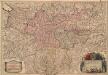
Le Comte de Tirol Les Evechés de Trente et de Brixen, &c
1 : 440000 Mollova mapová sbírka Jaillot, Alexis-Hubert Cordier, Louis Jaillot, Alexis Hubert
Reise- und Wanderkarte von Tirol, Vorarlberg und den angrenzenden Theilen von Bayern, der Schweiz & Italien
1 : 350000 Bavorsko (Německo) Freytag, Gustav G. Freytag & Berndt
Die Gefürstete Grafschaft Tyrol nebst Voralberg und Lichtenstein
Grosser Hand-Atlas über alle Theile der Erde in 170 Karten Meyer, J. Verlag des Bibliographischen Instituts
Gefürstete Grafschaft Tyrol nebst Vorarlberg und Lichtenstein
Radefeld, Carl Christian Franz Verlag d. Bibliograph. Inst.
Rhetiæ alpestris descriptio, in qua hodie Tirolis comitatvs
1 Karte : Kupferdruck ; 34 x 26 cm Lazius; Ortelius; Major s.n.
Rhetiæ alpestris descriptio, in qua hodie Tirolis comitatvs
1 Karte : Kupferdruck ; 34 x 26 cm Lazius; Ortelius; Major s.n.
Generalkarte der gefürsteten Grafschaft Tyrol nebst Vorarlberg und dem souverainen Fürstenthume Liechtenstein
1 : 290000 Lichtenštejnsko Stein, Carl Artaria
Generalkarte der gefürsteten Grafschaft Tyrol nebst Vorarlberg und dem souverainen Fürstenthume Liechtenstein
1 : 290000 Lichtenštejnsko Stein, Carl
Generalkarte der gefürsteten Grafschaft Tyrol nebst Vorarlberg und dem souverainen Fürstenthume Liechtenstein
1 : 287000 Lichtenštejnsko Stein, Carl
Comitatus Tirolis die Fürsliche Graffschafft Tyrol
Mollova mapová sbírka Neuräutter, Augustin Petr Neureutter, Augustin
Tirolensis Comit et Brixiensis Episc. Novissimus atque accuratissimus Tyrus complectens etiam Confinia Bavaria, Helvetiae, Tridentin ac. Venetiar Studio et arte
1 : 590000 Mollova mapová sbírka Schenk, Pieter Schenck, Petrus
Die Firstlich Graffschaft Tyrol.
Mollova mapová sbírka
Comitatvs Tyrolensis finitimarumque regionum nova exactissima descriptio
1 : 500000 Mollova mapová sbírka Ygl a Volldererthurn, Fridricus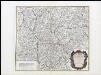
Le Tyrol sous le nom duqúel l'on comprend Le Comté De Tyrol, les Comtés annèxes de Bregentz, Feldkirck, Monfort, Pludentz, &c. et les Evéchés de Trente, Et De Brixen, sous la protection des Comtes de Tyrol
Robert de Vaugondy, Gilles
Le Tyrol sous le nom duqúel l'on comprend Le Comté De Tyrol, les Comtés annèxes de Bregentz, Feldkirck, Monfort, Pludentz, &c. et les Evéchés de Trente, Et De Brixen, sous la protection des Comtes de Tyrol
Robert de Vaugondy, Gilles
Le Tyrol sous le nom duquel l'on comprend Le Comté De Tyrol, les Comtés annèxes de Bregentz, Feldkirck, Monfort, Pludentz, &c. et les Evêchés de Trente, Et De Brixen
Robert de Vaugondy, Didier Santini

Neueste Generalkarte von Tyrol
1 : 296000 Tyrolsko (Rakousko) Wenzely, Anton von Anich, Peter F.A. Schraembl
Atlas Tyrolensis
Mollova mapová sbírka Anich, Peter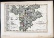
Tyrol nebst Vorarlberg und dem Souverainen Fürstenthum Lichtenstein
Radefeld, Carl Christian Franz Bibliograph. Inst.
Status Tirolensis
1 : 490000 Mollova mapová sbírka Valk, Gerhard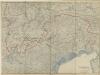
Tirol

Territorio Di Trento [Karte], in: Le théâtre du monde, ou, Nouvel atlas contenant les chartes et descriptions de tous les païs de la terre, Bd. 3, S. 162.
1 Karte aus Atlas Blaeu, Willem Janszoon und Blaeu, Joan Blaeu, Willem Janszoon