Maps of Northeast

Královehradecká dieceze
1 : 250000
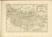
Partie de la Boheme du nord est
Chrudim-oblast (Česko) Kindermann, Joseph Karl Benedict, Ant. im Verlage des Kunst- und Industrie Comptoirs
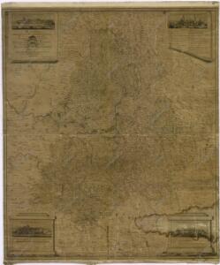
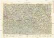
Nordöstlicher Theil von Boehmen enthaltend den Bunzlauer, Bidschower, Königgrätzer, Chrudimer, Czaslauer und Kaurzimer Kreis
1 : 540000 Chrudim-oblast (Česko) Kindermann, Joseph Karl Benedict, Ant. Kunst und Industrie Comptoir
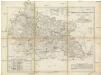
Církevní mapa biskupství Králové-Hradeckého

Mappa dioeceseos Reginaehradecensis
1 : 190000 Chrudim (Česko) Venuto, Jan Antonín Hay, Jan Leopold
Mappa dioceseos Reginaehradecensis in usum et commodum venerabilis cleridiocesani delineata
1 : 190000 Kraj Vysočina (Česko : 2000-) Venuto, Jan Antonín Hay, Jan Leopold
Mappa dioeceseos Reginaehradecensis
1 : 190000 Chrudim (Česko) Venuto, Jan Antonín Hay, Jan Leopold
Mappa dioeceseos Reginaehradecensis
1 : 190000 Chrudim (Česko) Venuto, Jan Antonín Hay, Jan Leopold
Mappa dioeceseos Reginaehradecensis
1 : 190000 Chrudim (Česko) Venuto, Jan Antonín Hay, Jan Leopold
G. Freytag – Autostrassenkarten: 20. Brünn

[Česko]
Česko
Hydrografische Uibersichtskarte der Flüsse, Bäche und sonstigen Gewässer im Königreiche Boehmen

Koenigreich Boehmen...

[Čechy]
Česko Wöber, Josef J. Kiss
[Nordostböhmen]
1 : 750000 Čechy severovýchodní (Česko)
Geologische Karte der Markgrafschaft Mähren und des Herzogthumes Schlesien
Foetterle, Franz
General-Karte des Königreiches Böhmen...

Übersichtskarte der Aerarialstrassen, Eisenbahnen, dann der floss... in Böhmen
Detail-Operations-Karte für den Krieg in Böhmen 1866
1 : 290000 Česko
III. vojenské mapování 3957/3
1 : 25000
Operations-Karte des nördlichen-Kriegsschauplatern Mähren
Karte des Bunzlauer- Jičiner- und Königgrätzer Kreises im oestreichischen Kronlande Boehmen
1 : 287000 Hradec Králové-oblast (Česko) Obentraut, Maxmilian Friedrich Kretzschmar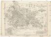
Karte des Bunzlauer- Jičiner- und Königgrätzer Kreises im oestreichischen Kronlande Boehmen
1 : 287000 Hradec Králové-oblast (Česko) Obentraut, Maxmilian Friedrich Kretzschmar
Prozkoumání Čech, sekce VI.

Regni Bohemiae Circuli Biczoviensis et Regionhradecensis...
Neubertova generální automapa Republiky československé
1 : 200000 Kolín (Česko : oblast) Soukup, Jan V. Neubert a synové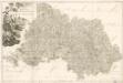
M. Provincia Reginohradecensis et Comitatus Glacensis

Östliches Böhmen