Maps of Suffolk
Des Königreichs England östlicher Theil, oder Surrey, Sussex, Kent, Middlessex, Essex
1 Karte : Kupferdruck ; 20 x 27 cm Reilly F. J. J. von Reilly

England & Wales SE.
1 : 633600 Stanford, Edward
England & Wales, south-eastern section; Channel Islands.
1 : 633600 John Bartholomew & Co.
Warwicum, Northamtonia, Huntingdonia, Cantabrigia, Suffolcia, Oxonium, Buckinghamia, Bedfordia, Hartfordia, Essexia, Berceria, Middelsexia, Southamptonia, Surria, Cantium & Southsexia. [Karte], in: Gerardi Mercatoris Atlas, sive, Cosmographicae meditationes de fabrica mundi et fabricati figura, S. 127.
1 Karte aus Atlas Mercator, Gerhard Montanus, Petrus
Warwicum, Northhamtonia, Huntingdonia, Cantabrigia, Suffolcia, Oxonium, Buckinghamia, Bedfordia, Hartfordia, Essexia, Berceria, Middelsexia, Southhamptonia, Surria, Cantium & Southsexia. [Karte], in: Atlas, sive, Cosmographicae meditationes de fabrica mundi et fabricati figura, S. 122.
1 Karte aus Atlas Mercator, Gerhard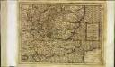
Warwicum Northhamtonia Hvntingdonia Cantabrigia, Svffolcia, Oxonivm, Bvckinghamia, Bedfordia Hartfordia Essexia Berceri Midelsexia, Sovthha[m]tonia Surria, Cantium Southsexia
1 Karte : Kupferdruck ; 17 x 24 cm Mercator Cloppenburgh
Warwicum, Northhamtonia, Huntingdonia, Cantabrigia, Suffolcia, Oxonium, Buckinghamia, Bedfordia, Hartfordia, Essexia, Berceria, Middelsexia, Southha[m]tonia, Surria, Cantiu[m] [et] Southsexia
1 Karte : Kupferdruck ; 35 x 45 cm Hondius; Mercator Henricus Hondius
Warwicum, Northhamtonia, Huntingdonia, Cantabrigia, Suffolcia, Oxonium, Buckinghamia, Bedfordia, Hartfordia, Essexia, Berceria, Middelsexia, Southha[m]tonia, Surria, Cantiu[m] [et] Southsexia
1 Karte : Kupferdruck ; 35 x 45 cm Hondius; Mercator Jodocus Hondius
Warwicum, Northamtonia, Huntingdonia, Cantabrigia, Suffolcia, Oxonium, Buckinghamia, Bedfordia, Hartfordia, Essexia, Berceria, Middelsexia, Southa[m]tonia, Surria, Cantiu[m] & Southsexia
1 : 815000
Carte des environs de Londres
1 Karte : Kupferdruck ; 48 x 66 cm Robert de Vaugondy; Arrivet; Fortin; Dussy; Browne chéz le Sr. Fortin ing.r mécanicien du roy rue de la harpe près la rue du Foin
Bassin de la Tamise : et bassins secondaires du Blackwater, du Stour et du versant de la Manche
1 : 600000 Vuillemin, Alexandre Aimé 1812-1880 Paris : Imprimerie et librairie Delalain
England V.
1 : 765000 Society for the Diffusion of Useful Knowledge (Great Britain)
England
1 : 778000 under the superintendence of the Society for the Diffusion of Useful Knowledge J. & C. Walker sculpt. London : Baldwin and Cradock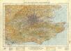
England and Wales 1:253,440
Ordnance Survey
General Map (London Environs).
Cary, John
Ordnance Survey of England and Wales (Aeronautical map)
Great Britain. War Office. General Staff. Geographical Section [London] : [Air Ministry],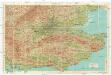
Bartholomew's "Quarter to mile" road map of the environs of London
1 : 25000 Hugh Rees
Ordnance Survey of England and Wales (Sheet 9), East Anglia
Ordnance Survey, Great Britain
A new travelling map of the country round London, 2
1 Blatt : 49 x 60 cm J. Andrews & A. Drury
delineation of the strata of England and Wales, with part of Scotland
1 : 320000 Blatt 11 Smith, William Cary
Sheet 9 Eastern Counties (S.), uit: Maps of England & Wales : scale 4 miles to 1 inch / Ordnance Survey
1 : 253440 titelvariant: Maps of England and Wales; Annotatie: Titel op cassette; Met bladoverzicht op de achterzijde van de cassette; Annotatie geografische gegevens: Hoogtelijneninterval 200 ft Ordnance Survey, United Kingdom Southampton : Ordnance Survey Office
Cambridgshire : described with the deuision of the hundreds, the townes situation, with the armes of the colleges of that famous vniuersiti and also the armes of all such princes and noblemen as haue heertofore borne the honorable tytles & dignities of the Earldome of Cambridge
1 : 109890 Speed, John, 1552?-1629 J. Sudbury and G. Humbell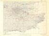
Britain, defences South of England and Wales
[London] : Ministry of Home Security
CANTII, Southsexiae, Surriae et Middlesexiae comitat Sheet 11
This map of Kent and the neighbouring counties of Sussex, Middlesex and Surrey is from the 1583 edition of the Saxton atlas of England and Wales. This atlas was first published as a whole in 1579. It consists of 35 coloured maps depicting the counties of England and Wales. The atlas is of great significance to British cartography as it set a standard of cartographic representation in Britain and the maps remained the basis for English county mapping, with few exceptions, until after 1750. During the reign of Elizabeth I map use became more common, with many government matters referring to increasingly accurate maps with consistent scales and symbols, made possible by advances in surveying techniques. Illustrating the increasing used of maps in government matters, Lord Burghley, Elizabeth I’s Secretary of State, who had been determined to have England and Wales mapped in detail from the 1550s, selected the cartographer Christopher Saxton to produce a detailed and consistent survey of the country. The financier of the project was Thomas Seckford Master of Requests at the Court of Elizabeth I, whose arms appear, along with the royal crest, on each map. In the bottom right corner a scale bar and a written description of the counties and of London. Although at a small scale London is shown in some detail in the map with St Paul’s Cathedral and London bridge clearly discernable. St Paul’s is correctly shown without its steeple which was destroyed by lightning in 1561 and was not replaced. Paddington Highgate and Camberwell are shown as outlying countryside, as yet un colonised by the metropolis. In neighbouring Berkshire Windsor is marked by a larger group of red structures than its neighbours, reflecting the royal association with Windsor and the presence of the castle, the park is also shown as a large wooded enclosure. Hampton Court is also marked. The name of the engraver Remigius Hogenberg, one of seven English and Flemish engravers employed to produced the copper plates for the atlas, is contained in the scale bar. Saxton, Christopher Ryther, Augustine
L'abbrucciamento fatto da gli vascelli Olandesi di quelli de gli Inglesi nella réuéera di Cattam anno 1666 24 di agosto
Chatham (Anglie) Bouttats, Gerhaert
L'abbrucciamento fatto da gli vascelli Olandesi di quelli de gli Inglesi nella réuéera di Cattam anno 1666 24 di agosto
Chatham (Anglie) Bouttats, Gerhaert
NORTHAMTON, Bedfordiae, Cantabrigiae,, Huntingdoniae et Rutlandiae Comitatum
This is a map of Northamptonshire, Bedfordfordshire, Cambridgeshire, Huntingdonshire and Rutland by Christopher Saxton, dating from 1576. It forms part of an atlas that belonged to William Cecil Lord Burghley, Elizabeth I’s Secretary of State. Burghley used this atlas to illustrate domestic matters. This map is actually a proof copy of one which forms part of Christopher Saxton’s Atlas of England and Wales. This atlas was first published as a whole in 1579. It consists of 35 coloured maps depicting the counties of England and Wales. The atlas is of great significance to British cartography as it set a standard of cartographic representation in Britain and the maps remained the basis for English county mapping, with few exceptions, until after 1750. During the reign of Elizabeth I, map use became more common, with many government matters referring to increasingly accurate maps with consistent scales and symbols, made possible by advances in surveying techniques. Illustrating the increasing use of maps in government matters, Lord Burghley, who had been determined to have England and Wales mapped in detail from the 1550s, selected the cartographer Christopher Saxton to produce a detailed and consistent survey of the country. The financier of the project was Thomas Seckford, Master of Requests at the Court of Elizabeth I, whose arms appear, along with the royal crest, on each map.Lord Burghley has added information to this map, adding place names and a park, symbolized by a depiction of fenced enclosure. Knowledge of the location of parks in an area was an important one when considering defence of the country as they could funtion as a service area for troops in need of rest. Saxton, Christopher William Cecil, Lord Burghley