Maps of Transdanubia

A Dunavölgy vizszabályozasi átnézeti térképe

[Wien-Ofen].
1 : 576000 Rakousko Blumtritt, H. Oesfeld, C. W.
Übersichtskarte von Mittel - Europa

Wien, Graz, Budapest
1 : 750000 Budapešť (Maďarsko : oblast) Karl, Ed. K. u. k. Militärgeographisches Institut
Wien, Graz, Budapest
1 : 750000 Budapešť (Maďarsko : oblast) K.u.k. militär-geographisches Institut
Wien, Graz, Budapest
1 : 750000 Budapešť (Maďarsko : oblast) K. u. k. militär-geographisches Institut
VIII, uit: General-Karte des oesterreichischen Kaiserstaates mit einem grossen Theile der angrenzenden Länder / durch Josef Scheda ... bearb. und hrsg
1 : 576000 Annotatie geografische gegevens: Maatstokken: oesterreichische Meilen, geografische oder deutsche Meilen, preussische Meilen, türkische Berri, französische Lieues, russische Werste; Maatstok per blad: wiener Klafter, öster. Meilen; Blad XIX: statistische en taalkundige informatie; Blad XIX: legenda [Wien : K.K. Militärisch-Geografisches Institut]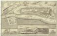
Plan de la fortresse de Bude vulgo Ofen
Budapešť (Maďarsko) Schmettau, Samuel von
[Rakousko-slovensko-maďarské pomezí].
Burgenland (Rakousko) Kipferling, Karl Joseph Walch, Johann
Stiria. Vinidor Marchia
Mollova mapová sbírka Hoffmann, Johannes Hoffmann, Johann
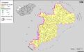
A szlovákok településterülete a szomszédsági mutató alapján Közép-Dunántúlon 1941-ban
Ungarn, Zentralungarn, Slowaken, Siedlung Bottlik, Zsolt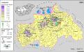
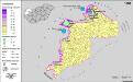
A németek településterülete a szomszédsági mutató alapján Közép-Dunántúlon 1941-ban
Ungarn, Zentralungarn, Deutsche, Siedlung Bottlik, Zsolt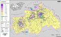
A németek településterülete a szomszédsági mutató alapján Közép-Dunántúlon 1880-ban
Ungarn, Zentralungarn, Deutsche, Siedlung Bottlik, Zsolt
Siedlungsgebiet der Slowaken nach dem Nachbarschaftsindex für Mittel-Transdanubien 1980
Ungarn, Zentralungarn, Slowaken, Siedlung Bottlik, Zsolt
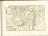
Niederungern
Maďarsko západní Kipferling, Karl Joseph Berken von Ottendorff, Johann im Verlage des Kunst- und Industrie Comptoirs
Niederungern
Maďarsko západní Kipferling, Karl Joseph Berken von Ottendorff, Johann im Verlage des Kunst- und Industrie Comptoirs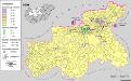
A szlovákok településterülete a szomszédsági mutató alapján Közép-Dunántúlon 1980-ban
Ungarn, Zentralungarn, Slowaken, Siedlung Bottlik, Zsolt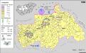
A németek településterülete a szomszédsági mutató alapján Közép-Dunántúlon 1980-ban
Ungarn, Zentralungarn, Deutsche, Siedlung Bottlik, Zsolt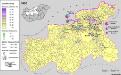
Siedlungsgebiet der Slowaken nach dem Nachbarschaftsindex für Mittel-Transdanubien 1880
Ungarn, Zentralungarn, Slowaken, Siedlung Bottlik, Zsolt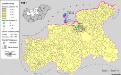
Siedlungsgebiet der Slowaken nach dem Nachbarschaftsindex für Mittel-Transdanubien 1941
Ungarn, Zentralungarn, Slowaken, Siedlung Bottlik, Zsolt
A szlovákok településterülete a szomszédsági mutató alapján Közép-Dunántúlon 1880-ban
Ungarn, Zentralungarn, Slowaken, Siedlung Bottlik, Zsolt
Siedlungsgebiet der Deutschen nach dem Nachbarschaftsindex für Mittel-Transdanubien 1941
Ungarn, Zentralungarn, Deutsche, Siedlung Bottlik, Zsolt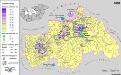
Siedlungsgebiet der Deutschen nach dem Nachbarschaftsindex für Mittel-Transdanubien 1880
Ungarn, Zentralungarn, Deutsche, Siedlung Bottlik, Zsolt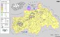
Siedlungsgebiet der Deutschen nach dem Nachbarschaftsindex für Mittel-Transdanubien 1980
Ungarn, Zentralungarn, Deutsche, Siedlung Bottlik, Zsolt
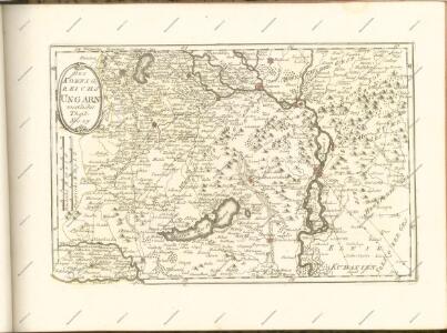
Mappa geographica almae dioecesis Weszprimiensis per inclytos comitatus Weszprim, Simigh et Zala
1 : 240000 Veszprém-oblast (Maďarsko) Vizer, Stephan Kopácsy, Joseph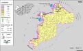
A németek településterülete a szomszédsági mutató alapján Nyugat-Magyarországon 1941-ban
Ungarn, Transdanubien, Deutsche, Siedlung Bottlik, Zsolt
Bez titulu: Přehledná mapa střední Evropy
A németek településterülete a szomszédsági mutató alapján Nyugat-Magyarországon 1880-ban
Ungarn, Transdanubien, Deutsche, Siedlung Bottlik, Zsolt