Maps of Europe


Nova Et Accurata Poli Arctici et terrarum Circum Iacentium Descriptio. [Karte], in: Het vijfde Deel Des Grooten Atlas : Vervatende De Water-Weereld, S. 53.
1 Karte aus Atlas Jansson, Jan Jansson, Jan
Northern Passage.
1 : 18000000 Thomson, John
Moscovia.
from A new systeme of the mathematicks: containing I. Arithmetick, as well natural and decimal, as in species, or the principles of algebra. II. Practical geometry, together with the first six books of Euclid's Elements, as also the eleventh and twelfth, symbo
Cotes, l'Amerique, l'Asie.
1 : 25000000 La Perouse, Jean-Francois de Galaup, comte de, 1741-1788
Chart of the Coasts of America and Asia.
1 : 19500000 La Perouse, Jean-Francois de Galaup, comte de, 1741-1788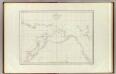
Cotes, l'Amerique, l'Asie.
1 : 25000000 La Perouse, Jean-Francois de Galaup, comte de, 1741-1788
Facsimile: Spanish Admiralty World in Mercator (portion).
1 : 15200000 Alaskan Boundary Tribunal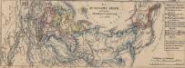
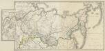
Das russische Reich nach seiner allmähligen Vergrösserung seit 1462
1 : 72000000 Russland / Asiatischer Teil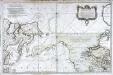
Carte réduite de l'ocean septentrional compris entre l'Asie et l'Amérique
1 Karte : Kupferdruck ; 54 x 84 cm Bellin s.n.
Chart of the Northern Passage between Asia & America
1 : 13500000 Neele, Samuel John John Thomson and Co.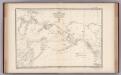
Facsimile: Russian Chart of the Frozen Ocean and the Eastern Ocean.
1 : 9800000 Alaskan Boundary Tribunal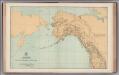
Facsimile: General Map. Parts of North America and Asia.
1 : 10340000 U.S. Coast and Geodetic Survey
Mapa pozemků dvora Borek
1 : 4801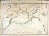
Carte des decouvertes faites par les Russes et par le capitaine anglois Jacques Cook dans la mer du Sud
1 Karte : Kupferdruck ; 52 x 79 cm Vil'brecht; Nabholz s.n.
Alaska.
1 : 7857000 Rand McNally and Company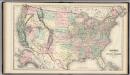
United States.
1 : 7240000 Gray, Ormando Willis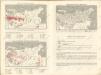
Sovětský svaz v mapách
Generalʹnaja Karta Azijatskoj Rossii : po novějšemu razděleniju na Gubernii, Oblasti i primorskija Upravlenija, s pokazaniem putej Rossijskich morechodcev
1 : 7000000 Sočinena Korpusa Topografov Porutčikom Poznjakovym [S.l.] : Voenno-Topografičeskom Depo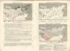
Sovětský svaz v mapách

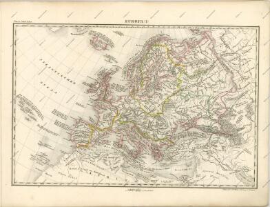
Evropa
1 Karte : Kupferdruck ; 38 x 46 cm Mercator; Mercator; Hondius Henricus Hondius
Evropa
1 Karte : Kupferdruck ; 38 x 46 cm Mercator; Mercator; Hondius Henricus Hondius?
Evropa
1 Karte : Kupferdruck ; 38 x 46 cm Mercator; Mercator; Hondius Jodocus Hondius
Ubersicht von Europa; mit ethnograph.
1 : 19008000 Berghaus, Heinrich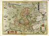
Nova Europæ descriptio
1 Karte : Kupferdruck ; 36 x 48 cm Hondius; Hondius Jodocus Hondius excudit
Nova Europæ descriptio
1 Karte : Kupferdruck ; 35 x 48 cm Hondius Jodocus Hondius excudit
Verbreitung und Vertheilung der Europaischen Vogel.
1 : 20000000 Berghaus, Heinrich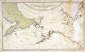
Karte von den n. w. amerikanischen und n. oe. asiatischen Küsten
1 Karte : Kupferdruck ; 38 x 66 cm Schrämbl; Roberts; Lackner zu finden in eigenem Verlage Schrämbl
Europa
1 Karte : Kupferdruck ; 47 x 55 cm Walch Johann Walch