Maps of Savoy

Sabaudia Ducatus. Savoye [Karte], in: Novus atlas absolutissimus, Bd. 4, S. 233.
1 Karte aus Atlas Janssonius Offizin
Sabaudia Ducatus. Savoye [Karte], in: Novus Atlas, das ist, Weltbeschreibung, Bd. 2, S. 162.
1 Karte aus Atlas Blaeu, Joan Blaeu, Willem Janszoon
Sabaudia Ducatus. Savoye [Karte], in: Le théâtre du monde, ou, Nouvel atlas contenant les chartes et descriptions de tous les païs de la terre, Bd. 2, S. 161.
1 Karte aus Atlas Blaeu, Willem Janszoon und Blaeu, Joan Blaeu, Willem Janszoon
Sabaudia Ducatus. Savoye [Karte], in: Theatrum orbis terrarum, sive, Atlas novus, Bd. 2, S. 163.
1 Karte aus Atlas Blaeu, Joan Blaeu, Willem Janszoon
Sabaudia Ducatus La Savoié [Karte], in: Gerardi Mercatoris et I. Hondii Newer Atlas, oder, Grosses Weltbuch, Bd. 2, S. 146.
1 Karte aus Atlas Mercator, Gerhard und Hondius, Jodocus Jansson, Jan
Sabavdia dvcatvs = Savoye
1 : 520000 titelvariant: Savoye; Annotatie: Origineel is Blad 153 in atlas factice; Annotatie geografische gegevens: Schaalstokken op kaart: 6 Milliaria Gallica (= 6,3 cm), en: 20 Milliaria Italica (= 7 cm) Amsterdami : apud Joan: Janssonium
Géographie. croquis n26, Suisse et Jura français
1 : 400000 Messain, Capitaine 18..-.... [Paris] : Service Géographique de l'Armée
Nouvelle carte géographique de la Suisse
1 : 600000 1 Karte auf 4 Bl. dressé par Jacq. Scheuchzer chez R. & J. Wetstein et Guil. Smith, Amsterdam
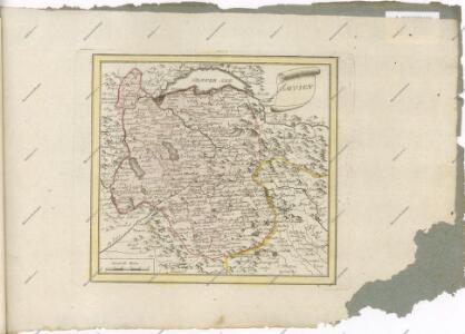
SABAVDIA | DVCATVS. | SAVOYE
Amsterdami | Apud Guiljelmum Blaeuw
Nova Rhaetiae atque totius Helvetiae descriptio
1 : 350000 1 Karte auf 10 Bl. per Aegidium Tschudum Glaronensem Hofer & Burger, Zürich
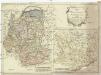
Karte von dem Herzogthume Savoyen und den Grafschaften Nizza, Tenda und Borgio, oder den Ländern welche der König von Sardinien in dem Frieden zu Paris den 15. May 1796 der französischen Republik abtrat
1 : 570000 Nice (Francie)
STATVVM ITALIAE SVPERIORIS vulgo olim LOMBARDIA dictorum geographica Delineatio
Lombardie (Itálie) Mayer, Tobias edentibus Homannianis Heredibus
Sabaudia ducatus
1 : 440000 Savojsko Hondius, Jodocus Judocus Hondius
Carte géologique de la Suisse
1 : 380000 1 Karte auf 4 Bl. par B. Studer et A. Escher de la Linth d'après leurs propres observations et les communications de leurs amis propriété de l'Etablissement topographique de J. Wurster & Comp., Winterthur
Tabvla generalis Sabavdiæ
1 Karte : Kupferdruck ; 49 x 58 cm Blaeu; Borgonio; Broen Ottens ...hos
Tabvla generalis Sabavdiæ
1 Karte : Kupferdruck ; 49 x 58 cm Blaeu; Borgonio; Broen Joannes Blaeu excudit
Hypsometrische Karte der Schweiz
1 : 380000 1 Karte auf 4 Blättern von J.M. Ziegler = Carte hypsométrique de la Suisse / par J.M. Ziegler Verlag von Joh. Wurster u. Comp., Winterthur
Duche de Savoye.
1 : 325000 Robert de Vaugondy, Gilles, 1688-1766
Sabavdia dvcatvs
1 Karte : Kupferdruck ; 36 x 48 cm Janssonius apud Joan: Janssonium
Sabavdia dvcatvs
1 Karte : Kupferdruck ; 36 x 47 cm Valck; Schenk apud G. Valk et P. Schenk
Sabavdia dvcatvs
1 Karte : Kupferdruck ; 36 x 47 cm Blaeu apud Guiljelmum Blaeuw
Sabaudia ducatus
1 Karte : Kupferdruck ; 17 x 24 cm Mercator Cloppenburgh
Sabaudia ducatus
1 Karte : Kupferdruck ; 35 x 48 cm Hondius; Goos Judocus Hondius excudit
Sabavdia dvcatvs
1 Karte : Kupferdruck ; 26 x 34 cm Merian

Les duchez de Savoye, de Chablais, et de Genevois, les comtez de Maurienne, et de Tarantaise, et la baronie de Fausigny
1 Karte : Kupferdruck ; 52 x 41 cm Fer chez le Sr. de Fer geographe de Sa Majesté catholique et de Monseigneur le dauphin dans l'Isle du palais sur le quay de l'Orloge a la sphere royale
Le département du Mont-Blanc
1 Karte : Kupferdruck ; 58 x 52 cm Raymond; Boutrois chez l'auteur rue des Maçons-sorbonne no. 441