Maps of Oxfordshire

England and Wales 1:253,440
Ordnance Survey
A new travelling map of the country round London, 1
1 Blatt : 49 x 61 cm J. Andrews & A. Drury
Oxonii, buckinghamiae et berceriae comitatum
This is a map of Oxfordshire, Buckinghamshire and Berkshire by Christopher Saxton which dates from 1574. It forms part of an atlas that belonged to William Cecil Lord Burghley, Elizabeth I’s Secretary of State. Burghley used this atlas to illustrate domestic matters. This map is actually a proof copy of one which forms part of Christopher Saxton’s Atlas of England and Wales. This atlas was first published as a whole in 1579. It consists of 35 coloured maps depicting the counties of England and Wales. The atlas is of great significance to British cartography as it set a standard of cartographic representation in Britain and the maps remained the basis for English county mapping, with few exceptions, until after 1750. During the reign of Elizabeth I, map use became more common, with many government matters referring to increasingly accurate maps with consistent scales and symbols, made possible by advances in surveying techniques. Illustrating the increasing use of maps in government matters, Lord Burghley, who had been determined to have England and Wales mapped in detail from the 1550s, selected the cartographer Christopher Saxton to produce a detailed and consistent survey of the country. The financier of the project was Thomas Seckford Master of Requests at the Court of Elizabeth I, whose arms appear, along with the royal crest on each map. Lord Burghley has added several place names to the map. The name of the engraver of the map has not been included but would have been one of a team of seven English and Flemish engravers employed to produce the copper plates for the atlas. Saxton, Christopher
Oxonii, buckinghamiae et berceriae Comitatuum
This map of Oxfordshire and the neighbouring counties of Buckinghamshire and Berkshire is from the 1583 edition of the Saxton atlas of England and Wales. This atlas was first published as a whole in 1579. It consists of 35 coloured maps depicting the counties of England and Wales. The atlas is of great significance to British cartography as it set a standard of cartographic representation in Britain and the maps remained the basis for English county mapping, with few exceptions, until after 1750. During the reign of Elizabeth I map use became more common, with many government matters referring to increasingly accurate maps with consistent scales and symbols, made possible by advances in surveying techniques. Illustrating the increasing used of maps in government matters, Lord Burghley, Elizabeth I’s Secretary of State, who had been determined to have England and Wales mapped in detail from the 1550s, selected the cartographer Christopher Saxton to produce a detailed and consistent survey of the country. The financier of the project was Thomas Seckford Master of Requests at the Court of Elizabeth I, whose arms appear, along with the royal crest, on each map. Saxton, Christopher Ryther, Augustine

Oxonium Comitatus, Vulgo Oxford Shire. [Karte], in: Theatrum orbis terrarum, sive, Atlas novus, Bd. 4, S. 237.
1 Karte aus Atlas Blaeu, Joan Blaeu, Willem Janszoon
Oxonium Comitatus Vulgo Oxford Shire. [Karte], in: Novus atlas absolutissimus, Bd. 7, S. 230.
1 Karte aus Atlas Janssonius Offizin
Oxonium Comitatus, Vulgo Oxford Shire. [Karte], in: Le théâtre du monde, ou, Nouvel atlas contenant les chartes et descriptions de tous les païs de la terre, Bd. 4, S. 209.
1 Karte aus Atlas Blaeu, Willem Janszoon und Blaeu, Joan Blaeu, Willem Janszoon
Oxonium Comitatus, Vulgo Oxford Shire. [Karte], in: Theatrum orbis terrarum, sive, Atlas novus, Bd. 4, S. 237.
1 Karte aus Atlas Blaeu, Joan Blaeu, Willem Janszoon
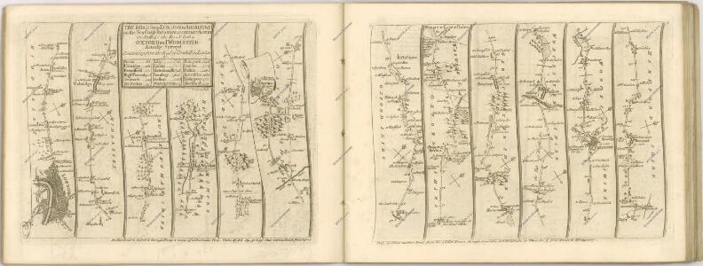
Sheets 23-24. (Cary's England, Wales, and Scotland).
1 : 360000 Cary, John, ca. 1754-1835
Buckingamiae Comitatus cum Bedfordiensi; vulgo Buckingamshire and Bedfordshire. [Karte], in: Novus atlas absolutissimus, Bd. 7, S. 239.
1 Karte aus Atlas Janssonius Offizin
GLOCESTRIAE Sive Claudiocestriae Comitat.
This is a map of Gloucestershire by Christopher Saxton dating from 1577. It forms part of an atlas that belonged to William Cecil Lord Burghley, Elizabeth I’s Secretary of State. Burghley used this atlas to illustrate domestic matters. This map is actually a proof copy of one which forms part of Christopher Saxton’s Atlas of England and Wales. This atlas was first published as a whole in 1579. It consists of 35 coloured maps depicting the counties of England and Wales. The atlas is of great significance to British cartography as it set a standard of cartographic representation in Britain and the maps remained the basis for English county mapping, with few exceptions, until after 1750. During the reign of Elizabeth I, map use became more common, with many government matters referring to increasingly accurate maps with consistent scales and symbols, made possible by advances in surveying techniques. Illustrating the increasing use of maps in government matters, Lord Burghley, who had been determined to have England and Wales mapped in detail from the 1550s, selected the cartographer Christopher Saxton to produce a detailed and consistent survey of the country. The financier of the project was Thomas Seckford, Master of Requests at the Court of Elizabeth I, whose arms appear, along with the royal crest, on each map. Burghley has annotated this map, adding place names along the river Sabrina Flu and at points on other rivers near Bristol. Dotted lines have also been added, possibly indicating communication routes. Black marks have been added at tributary mouths. These additions to the waterways of the area possibly reflect a concern that enemy invaders could sail up the Bristol Channel. At this time England was under threat of invasion from Catholic Spain, a threat which culminated in the events of the Spanish Armada. The map was engraved by Augustinus Ryther, the most accomplished of a team of seven English and Flemish engravers employed to produce the copper plates for the atlas. Saxton, Christopher Ryther,Augustinus
Oxonium Comitatus vulgo Oxford Shire
1 : 220000 [Amstelodami] : [apud Joannem Janssonium]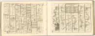

Buckingamiae comitatus cum Bedfordiensi, vulgo Buckingamshire and Bedfordfhire
1 : 180000 Amstelodami : apud Joannem Janssonium
OXONIVM | Comitatus, Vulgo | OXFORD SHIRE.
Ioh. Blaeu excud.
Buckinghamiensis Comitatus; Anglis Buckingham Shire. [Karte], in: Theatrum orbis terrarum, sive, Atlas novus, Bd. 4, S. 247.
1 Karte aus Atlas Blaeu, Joan Blaeu, Willem Janszoon
Glocestria Ducatus; Vulgo Glocester Shire. [Karte], in: Theatrum orbis terrarum, sive, Atlas novus, Bd. 4, S. 228.
1 Karte aus Atlas Blaeu, Joan Blaeu, Willem Janszoon
Glocestria Ducatus; Vulgo Glocester Shire. [Karte], in: Le théâtre du monde, ou, Nouvel atlas contenant les chartes et descriptions de tous les païs de la terre, Bd. 4, S. 202.
1 Karte aus Atlas Blaeu, Willem Janszoon und Blaeu, Joan Blaeu, Willem Janszoon
Buckinghamiensis Comitatus; Anglis Buckingham Shire. [Karte], in: Le théâtre du monde, ou, Nouvel atlas contenant les chartes et descriptions de tous les païs de la terre, Bd. 4, S. 219.
1 Karte aus Atlas Blaeu, Willem Janszoon und Blaeu, Joan Blaeu, Willem Janszoon
Glocestria Ducatus; Vulgo Glocester Shire. [Karte], in: Theatrum orbis terrarum, sive, Atlas novus, Bd. 4, S. 228.
1 Karte aus Atlas Blaeu, Joan Blaeu, Willem Janszoon
GLOCESTRIA, | DVCATVS; | Vulgo | GLOCESTER | SHIRE.
[Amsterdam : Joan Blaeu]
Buckinghamiensis Comitatus; Anglis Buckingham Shire. [Karte], in: Theatrum orbis terrarum, sive, Atlas novus, Bd. 4, S. 247.
1 Karte aus Atlas Blaeu, Joan Blaeu, Willem Janszoon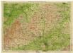
England & Wales [Bartholomew's "Half-inch to the mile" Map of]
J. Bartholomew
Oxonium comitatus vulgo Oxford Shire
1 Karte : Kupferdruck ; 36 x 47 cm Valck; Schenk apud Gerardum Valk et Petrum Schenk
Oxonivm comitatus, vulgo Oxford Shire
1 Karte : Kupferdruck ; 37 x 42 cm Blaeu Joan Blaeu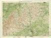
Oxford, Sheet 24 - Bartholomew's "Half Inch to the Mile Maps" of England & Wales
1 : 126720 Topographic maps Bartholomew, John George John Bartholomew & Co
GLOCESTRAE Sive Claudiocestriae Comitat
This map of Gloucestershire is from the 1583 edition of the Saxton atlas of England and Wales.This atlas was first published as a whole in 1579. It consists of 35 coloured maps depicting the counties of England and Wales. The atlas is of great significance to British cartography as it set a standard of cartographic representation in Britain and the maps remained the basis for English county mapping, with few exceptions, until after 1750. During the reign of Elizabeth I map use became more common, with many government matters referring to increasingly accurate maps with consistent scales and symbols, made possible by advances in surveying techniques. Illustrating the increasing used of maps in government matters, Lord Burghley, Elizabeth I’s Secretary of State, who had been determined to have England and Wales mapped in detail from the 1550s, selected the cartographer Christopher Saxton to produce a detailed and consistent survey of the country. The financier of the project was Thomas Seckford Master of Requests at the Court of Elizabeth I, whose arms appear, along with the royal crest, on each map. Saxton, Christopher Ryther, Augustine