Maps of Highland


MAGNAE BRITANNIAE
1 : 970000 Skotsko Vischer, Georg Matthaeus Homann, Johann Baptist Iohan. Bapt. Homanno
MAGNAE BRITANNIAE
1 : 970000 Skotsko Vischer, Georg Matthaeus Homann, Johann Baptist Iohan. Bapt. Homanno
Magnae Britanniae pars septentrionalis qua regnum Scotiae
1 : 950000 Skotsko Vischer, Georg Matthaeus Homann, Johann Baptist J. B. Homann
Scotland.
1 : 2000000 Lucas, Fielding Jr.
Charte von Schottland
Skotsko
CHARTE von SCHOTTLAND
Skotsko
Scotland.
1 : 1140000 Rand McNally and Company
Scotland.
1 : 1600000 Colton, G.W.
Ecosse.
1 : 2000000 Malte-Brun, Conrad, 1775-1826
Nova et accurata totius regni Scotiae, secundum omnes provincias et adjacentes insulas, exquisito studio determinatae, delineatio
1 : 958000 Skotsko Lotter, Tobias Conrad Silbereysen, And. sumtibus Tobiae Conradi Lotteri
Composite: Scotland.
1 : 633300 Johnston, W. & A.K.
Scotland.
1 : 1650000 Carey, Mathew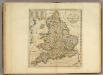
Scotland.
1 : 1550000 Carey, Mathew
Scotland.
1 : 1584000 Carey, Mathew
Scotland.
1 : 1520640 Carey, Mathew
Scotland.
1 : 1520640 Carey, Mathew
Scotia Regnum
1 : 1345000
Map of Scotland
1 : 700000
Neueste Karte von Schotland
Grosser Hand-Atlas über alle Theile der Erde in 170 Karten Meyer, J. Verlag des Bibliographischen Instituts
Index map.
1 : 1200000 Thomson, John
L'Ecosse
1 Karte : Kupferdruck ; 54 x 47 cm Le Rouge; Basset; Basset chez Basset rue Saint Jacques
Nova et accurata totius regni Scotiæ, secundum omnes provincias et adjacentes insulas, exquisito studio determinatæ, delineatio
1 Karte : Kupferdruck ; 56 x 48 cm Lotter; Silbereisen Tobias Konrad Lotter
L'Ecosse
1 Karte : Kupferdruck ; 54 x 47 cm Le Rouge; Bowles chés le Sr. le Rouge ingen.r géog. du roy rue des grands Augustins
Nova et accurata totius regni Scotiæ, secundum omnes provincias et adjacentes insulas, exquisito studio determinatæ, delineatio
1 Karte : Kupferdruck ; 56 x 48 cm Seutter; Silbereisen Matthäus Seutter
Scotia regnum
1 Karte : Kupferdruck ; 56 x 49 cm Wit ex officina J. Cóvens et C. Mortier
Novissima regni Scotiæ septentrionalis et meridionalis tabula
1 Karte : Kupferdruck ; 49 x 58 cm by I. Cóvens en C. Mortier op de Vygendam
Scotia Cambdeni et Sibbaldi
1 Karte : Kupferdruck ; 37 x 31 cm Weigel; Camden; Sibbald; Kauffer Christoph Weigel
Novissima regni Scotiæ septentrionalis et meridionalis tabula
1 Karte : Kupferdruck ; 56 x 48 cm Schenk Pieter Schenk
Nouvelle carte d'Ecosse
1 Karte : Kupferdruck ; 33 x 31 cm Châtelain s.n.
Regnum Scotiæ, seu pars septent: Magnæ Britanniæ
1 Karte : Kupferdruck ; 46 x 58 cm Valck; Valck G. und L. Valck
Magnæ Britanniæ pars septentrionalis qua regnum Scotiæ in suas partes et subjacentes insulas divisum accurata tabula
1 Karte : Kupferdruck ; 56 x 46 cm Visscher; Homann Johann Baptist Homann
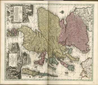
Le royaume d'Escosse
1 Karte auf 2 Blatt : Kupferdruck ; 84 x 57 cm Sanson; Jaillot chez H. Jaillot
Scotia regnum
1 Karte : Kupferdruck ; 56 x 49 cm Wit ex officina Frederici de Witt
Scotia regnvm
1 Karte : Kupferdruck ; 37 x 49 cm Janssonius apud Ioannem Ianssonium
Novissima regni Scotiæ septentrionalis et meridionalis tabula
1 Karte : Kupferdruck ; 49 x 58 cm Allard by Carolus Allard op den dam
Exactissima regni Scotiæ tabula
1 Karte : Kupferdruck ; 55 x 46 cm Visscher Visscher
Scotia regnvm
1 Karte : Kupferdruck ; 37 x 48 cm Blaeu Joan Blaeu
Scotia, regnum
1 Karte : Kupferdruck ; 33 x 39 cm Mercator; Hondius Henricus Hondius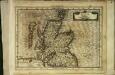
Scotia, regnum
1 Karte : Kupferdruck ; 17 x 24 cm Mercator Cloppenburgh
Scotia, regnum
1 Karte : Kupferdruck ; 33 x 38 cm Mercator; Hondius Jodocus Hondius
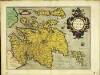
Scotiæ tabvla
1 Karte : Kupferdruck ; 35 x 47 cm Ortelius s.n.