Maps of Metropolitan France

France Villes
Vidal de La Blache, Paul
France Chemins de Fer Principales lignes de navigation
Vidal de La Blache, Paul
France Villes
Vidal de La Blache, Paul
France relief du sol
Vidal de La Blache, Paul
France divisions militaires
Vidal de La Blache, Paul
France cours d'eau
Vidal de La Blache, Paul
France Chemins de Fer Principales lignes de navigation
Vidal de La Blache, Paul
Carte physique et routiere de la France, de la Suisse.
1 : 2000000 Brue, Adrien Hubert, 1786-1832
France Provinces en 1789
Vidal de La Blache, Paul
Regni Galliae seu Franciae et Navarrae...

France Agriculture
Vidal de La Blache, Paul
Carte de la France
1 : 3200000 Francie Poirson Jean M.d d'Estampes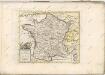

France cours d'eau
Vidal de La Blache, Paul
France relief du sol
Vidal de La Blache, Paul
France Physique.
1 : 2500000 Vivien St Martin, L.
France Industrie et commerce
Vidal de La Blache, Paul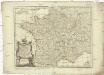
Carte de France
1 : 2060000 Francie Dezauche, Jean-André Delisle, Guillaume Dezauche
France, in Departments.
1 : 4500000 Finley, Anthony
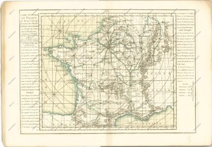
Nouvelle carte des postes de France
1 Karte : Kupferdruck ; 50 x 63 cm Jaillot; Jaillot chez le Sr. Jaillot geographe du roy joignant les g.ds Augustins aux deux globes
Le royaume de France et les conquetes de Louis de Grand
1 : 3100000 Alžír (Alžírsko) Steinberger, Johann Christoph Wolf, Jeremias Ieremias Wolf
Le royaume de France et les conquetes de Louis de Grand
1 : 3100000 Francie Inselin, Charles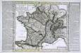
Carte physyque de la France
1 Karte : Kupferdruck ; 30 x 35 cm, Bildgrösse 34 x 53 cm Pasquier; Chalmandrier; Verrier; Denis chez l'auteur, chez Mr. Pasquier ruë St. Jacques vis-a-vis le college de Louis le grand, chez Verrier géographe du roi ruë des 4 fils aux marais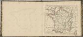
[Francie]
1 : 2100000 Francie Müller, Franz
France in Departments.
1 : 2232000 Johnston, Alexander Keith
Les routes exactes des postes du Royaume de France
1 : 2600000 Aug. Vindel. : Matth. Seutter excud.
Nieuwe kaart van Vrankrijk, volgens de nieuwste waarnemingen van de Koningl. Parijsche Academie
1 : 5750000 [S.l.] : [s.n.]