Maps of District of Rimavská Sobota

C. Gömöriensis
Slowakei Komitat Gemer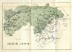
Stolice Zvolen a Gemer
Komitat Altsohl, Komitat Gemer, ethnische Gruppe
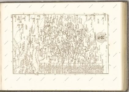
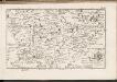
Gömör vármegye és a' vele törvényesen egyesült Kis-Honti kerület
1 : 240000 Gemer (Slovensko : oblast) Ráisz, Christ. Benedicti, Hieronymus Görög
C. Tornensis
Ungarn Komitat Torna
Rima-Szombat 135, uit: Special-Karte von Mittel-Europa / nach amtlichen Quellen bearbeitet von W. Liebenow
1 : 300000 titelvariant: W. Liebenow's Mittel-Europa; Annotatie: Titel boven de bladen: W. Liebenow's Mittel-Europa Johannes Wilhelm Liebenow 1822-1897 Frankfurt a. M. : Ludwig Ravenstein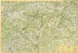
Slovenské rudohorie

Nagy-Rocze und Rimm-Banya (Ungarn).
from Spezialkarte der osterreichisch-ungarischen Monarchie.
Quellencebiet Der Cran.
from Spezialkarte der osterreichisch-ungarischen Monarchie.
Rimavská Sobota, Číž – Domica

Tornal'a a okolí
1 : 75000 Vojenský zeměpisný ústav
Quellengebiet der Gran (Garam)
1 : 75000 Hron (Slovensko : řeka : oblast) Kartografické odd. při Min. nár. obrany
Revúca
1 : 75000 Revúca-oblast (Slovensko) Vojenský zeměpisný ústav
Revúca
1 : 75000 Revúca (Slovensko : oblast) Vojenský zeměpisný ústav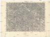
Revúca
1 : 75000 Revúca (Slovensko : oblast) Vojenský zeměpisný ústav
Revúca
1 : 75000 Revúca (Slovensko : oblast) Vojenský zeměpisný ústav
III. vojenské mapování 4564
1 : 75000
Pohorelá
1 : 75000 Slovensko Vojenský zeměpisný ústav
Pohorelá
1 : 75000 Slovensko Vojenský zeměpisný ústav
Rima-Szombat
1 : 75000 Rimavská Sobota Schrift u. Gerippe v. Führ. Schwarz. Terrainschraffirung v. Fwkr. Nowak u. R. Bloschitz
Nagy-Rőcze und Rima-Bánya
1 : 75000 Revúca, Rimavská Baňa Schrift u. Gerippe v. Objgr. Spaczek. Terrainschraffirung v. A. Hertel
Rima-Szombat (Ungran).; Spezialkarte der osterreichisch-ungarischen Monarchie.
from Spezialkarte der osterreichisch-ungarischen Monarchie. Austro-Hungarian Monarchy. Militärgeographisches Institut.,
Quellencebiet Der Cran.; Spezialkarte der osterreichisch-ungarischen Monarchie.
from Spezialkarte der osterreichisch-ungarischen Monarchie. Austro-Hungarian Monarchy. Militärgeographisches Institut.,
III. vojenské mapování 4664
1 : 75000
III. vojenské mapování 4464
1 : 75000
Rimavska Sobota
1 : 75000 Maďarsko Vojenský zeměpisný ústav
Rimavska Sobota
1 : 75000 Maďarsko Vojenský zeměpisný ústav
Rimavska Sobota
1 : 75000 Maďarsko Vojenský zeměpisný ústav