Maps of Styria


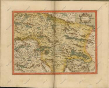
Ducatus Stiriae novissima tabula
1 : 470000 Štýrsko (Rakousko) Homann, Johann Baptist Vischer, Georg Matthaeus a Ioh. Bapti. Homanno
Geographischer Entwurff des Herzogthums Steyermarck nach Der neuen Eintheilung in 5. Creÿse und der perpetuirl. Marche-Route
1 : 460000 Mollova mapová sbírka Diettel, Christoph
Ducatus Styriae Tabula
1 : 950000 Mollova mapová sbírka Engelbrecht, Christian Engelbrecht, Martin
Ducatus Styriae Tabula
1 : 950000 Mollova mapová sbírka Pfeffel, Johann Andreas
Stiria Ducatus juxta recentissimas observationes et accuratissimas mappas commoda hac forma aeri sculptus et usui publico destinatus
1 : 475000 Mollova mapová sbírka Seutter, Matthäus Seutter, Matthäus
Ducatûs Stiriae Novissima Tabula ex ampliore mappa olim R.Dmi. Georgii Matth. Vischer, S.C.M. Leopoldi I. Glor. Mem. Geographi deducta
1 : 470000 Mollova mapová sbírka Homann, Johann Baptist Homann, Johann Baptista
Stiria Vulgo Steyrmarck
1 : 433300 Mollova mapová sbírka Schenk, Peter I
Styria
1 : 416000 Mollova mapová sbírka Blaeu, Willem Janszoon Blaeu, Willem Jansz.
Stiria = Steyrmarck /
1 : 600000 Mollova mapová sbírka Merian, Matthäus Merian, Matthäus
Strassen-Karte des Herzogthums Steyermark
1 : 435000 Štýrsko (Rakousko)
General-Karte des Herzogthums Steyermark
1 : 288000 Slovinsko
[Štýrsko]
1 : 600000 Štýrsko (Rakousko) Anker
Ducatus Stiriae novissima tabula
1 : 490000 Rakousko Homann, Johann Baptist Vischer, Georg Matthaeus J. B. Homann
Charte von Innerösterreich oder den vereinigten Herzogthümern Steyermark und Kaernten
1 : 725000 Korutansko (Rakousko) im Kunst und Industrie Comptoir
Vollstaendige Post-Karte des Herzogthums Steuermarks

Strassen-Karte des Herzogthums Steyermark
1 : 432000 Štýrsko (Rakousko)
Post und Strassen Karte des Herzogthums Steyermark
1 : 380000 Mariazell (Rakousko) Schulz, R. A. Biller, Dominik Artaria & Comp.
General Post und Strassen Karte des Herzogthums Steyermark
1 : 380000 Mariazell (Rakousko) Schulz, R. A. Artaria & Comp.
Ducatus Styriae tabula
1 : 925000 Štýrsko (Rakousko) Granelli, Carlo Engelbrecht, Christian Engelbrecht et Pfeffel
Stiria ducatus
1 : 505700 Rakousko Lotter, Tobias Conrad per Tob. Conrad Lotter
Stiria ducatus
1 : 505700 Rakousko Lotter, Tobias Conrad per Tob. Conrad Lotter
Stiria ducatus
1 : 505700 Štýrsko (Rakousko) Lotter, Tobias Conrad per Tob. Conrad Lotter
General Post und Strassen Karte des Herzogthums Steiermark
1 : 400000 Mariazell (Rakousko) Schulz, R. A. Peucker, Karl Artaria


Ducatus Styriae novissima tabula
1 : 830000 Mollova mapová sbírka Weigel, Christoph Weigel, Christoph
General-Karte von Steiermark
Lechner, R.
Charte von Steyermark
Štýrsko (Rakousko) Kindermann, Joseph Karl Müller, Franz im Verlage des Kunst- und Industrie- Comptoirs
Charte von Steyermark
Štýrsko (Rakousko) Kindermann, Joseph Karl Müller, Franz im Verlage des Kunst- und Industrie-Comptoirs