Maps of Landkreis Straubing-Bogen


Bairische Landtafeln XXIIII. Darinnē das hochlöblich Furstenthumb Obern unnd Nidern Bayrn sambt der Obern Pflaz Erz unnd Stifft Salzburg Eichstet unnd andern mehrern anstossenden Herschafftē]
1 : 145000 Mollova mapová sbírka Apian, Philipp Amman, Jost Apian, Petrus
165. Cham, uit: Topographische Uebersichtskarte des Deutschen Reiches / herausgegeben v. d. Kartogr. Abt. d. Königl. Preuß. Landesaufnahme
1 : 200000 titelvariant: Topogr. Übersichtskarte des Deutschen Reiches; Annotatie: Titel boven bladen ook: Topogr. Übersichtskarte des Deutschen Reiches; Annotatie geografische gegevens: Op elk blad twee maatstokken: 10 Kilometer = 5,5 cm; 1 geogr. Meile = 3,6 cm; Legenda onder op elk blad Königlich Preußische Landesaufnahme. Kartographische Abtheilung [S.l : Königlich Preußische Landesaufnahme, Kartographische Abtheilung]
S. R. Imp. Circuli Franconici Geographica Delineatio Francken-Land mit Seinen Gräntzen
Mollova mapová sbírka Endter, Wolfgang Moritz Endter, Wolfgang Moritz
Müllerova mapa Čech
1 : 132000
exhibet Continuationem Partis Palatinatus Super: Regiminis Straubing: et Villam Jmperialem Augusta Tiberii
1 : 150000 Mollova mapová sbírka Buna, Wilhelm C. Broenner, Heinrich Ludwig
Pars II. exhibet continuationem partis palatinatus super: regiminis Straubing: et villam jmperialem Augusta Tiberii
1 Karte : 54 x 52 cm Heinrich Ludwig Broenner
Continuations Plan deren Königl. Kriegs Unsernehmungen in Bayern
Mollova mapová sbírka Lidl, Johann Jakob Lidl, Johann Jacob
Mappa geographica regni Bohemiae in duodecim circulos divisae ...

Entwurf der Bewegungen und Schlachten welche den 19. 20. 21. 22. und 23. April 1809 zwischen den Alliirt. Französischen und Oestreichischen Armeen in den Gegenden von Tann, Abensberg, Landshuth, Ekmühl, Regensburg, die Campagne eröffneten

Regensburg 130, uit: Special-Karte von Mittel-Europa / nach amtlichen Quellen bearbeitet von W. Liebenow
1 : 300000 titelvariant: W. Liebenow's Mittel-Europa; Annotatie: Titel boven de bladen: W. Liebenow's Mittel-Europa Johannes Wilhelm Liebenow 1822-1897 Frankfurt a. M. : Ludwig Ravenstein
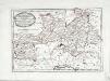
Sacri Romani imperii circuli et electoratus Bavariae tabula, 4
4 Blätter : s.n.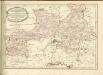

An den Pilsner und Klattauer und Prachiner Kr [sic] angrezende Baiern
Bavorsko (Německo) Kreibich, František Jakub Jindřich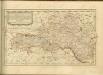

Pilsner Kreis
Plzeň (Česko : oblast) Berndt, Johann Christoph Anton Elsenwanger
Pilsner Kreis
Plzeň-oblast (Česko) Berndt, Johann Christoph Anton Elsenwanger
Pilsner Kreis
Plzeň-oblast (Česko) Berndt, Johann Christoph Anton Elsenwanger
C. Flemming's Karte von Deutsch - Französischen Kriegsschaupltze

Sacri Imperii Romani Circuli et Electoratus Bavariae cum Finitimis Geographica Descriptio. Cum Privilegio D.D. Ordinum Generalium ut et Hollandiae West Frisiaequae]
1 : 270000 Mollova mapová sbírka Valck, Leonardus
Carte topographique d'Allemagne contenant le Haut Palatinat, une partie du royaume de Boheme, de la Basse Baviere
1 Karte : Kupferdruck ; 46 x 61 cm Jaeger; Facius I. W. A. Iaeger ches qui cette carte se vend
Kraj plzeňský
Des Herzogthums Oberpfalz südliche Pfleggerichte
1 Karte : Kupferdruck ; 24 x 35 cm Reilly F. J. J. von Reilly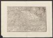
Militair Karte von Süd-Deutschland in 20 Sectionen
1 : 400000 11. Section Coulon, Alois von A. von Coulon
Sacri imperii Romani circuli et electoratus Bavariæ, 2
1 Karte : mehrfarbig ; R. et J. Ottens
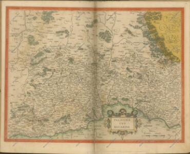
Palatinatvs Bavariæ
1 Karte : Kupferdruck ; 35 x 47 cm Valck; Schenk apud G. Valk et P. Schenk
Palatinatvs Bavariæ
1 Karte : Kupferdruck ; 36 x 48 cm Blaeu excudit Guiljelmus Blaeuw
Palatinatvs Bavariæ
1 Karte : Kupferdruck ; 35 x 48 cm Hondius; Mercator; Janssonius apud Ioannem Ianssonium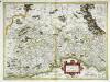
Palatinatvs Bavariae
1 Karte : Kupferdruck ; 35 x 48 cm Mercator; Hondius excusum apud Henricum Hondium sub insigno Atlantis