Maps of Belgium


Paasche's Frontenkarte, Nr.13. Der Krieg gegen Russland

Paasche's Frontenkarte, Nr.4. Der Krieg gegen Russland

Paasche's Frontenkarte, Nr.17. Der Krieg gegen Russland

Panoramatic View of the frontier between France and Germany
1 : 771000 Francie Meinhard, R. Julius Abelsdorff
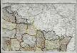
Les gouvernements de Flandre, de Picardie, d'Artois, de l'Isle de France, et de Champagne
1 : 5840000 Artois (Francie) Bonne, Rigobert André
Distribution of German forces on the Western Front
1 : 750000 First World War map of the distribution of German forces on the Western Front according to captured map dates 30th Oct. 1918. Title of base sheet 'Map of the Western Theatre of War'. War Office
Paasche's Frontenkarte, Nr.15. Der Krieg gegen Russland

Paasche's Frontenkarte, Nr.14. Der Krieg gegen Russland

Nordost-Frankreich und Belgien
1 : 750000 Belgie Justus Perthes
Reliefkarte von Nordost-Frankreich
Carte Physique et Militaire de la Frontiere du Nord-Est.
1 : 1000000 Jouvet et Cie.
Théatre de la guerre, ou carte des frontières de la république française et de l'empire d'Allemagne, 1
1 Teil : Delamarche
The Western Front. June 1918.
1 : 600000 First World War map of the Western Front. June 1918. Front Line June 12th, June 5th and March 20th. War Office
Western Front. Front line on March 20th, Aug.16th, Sept. 18th 1918.
1 : 600000 First World War map of the Western Front. Front line on March 20th, Aug.16th, Sept. 18th 1918. Shows limits of German advance in 1918. War Office
Carte de la France (NE)
1 : 345600 Cassini family
Einsatz der 1./Pz. Rgt. 2 im Westen vom 10. 5. - 6. 9. 1940
Francie Veit Carl Kaestner
France Picardie Champaigne cum regionibus adiacentibus. [Karte], in: Gerardi Mercatoris Atlas, sive, Cosmographicae meditationes de fabrica mundi et fabricati figura, S. 232.
1 Karte aus Atlas Mercator, Gerhard Montanus, Petrus
Kriegs Atlas 36 Karten von den Schauplätzen des Weltkrieges 1914/1915

[Geologische Profile von Deutschland im Allgemeinen u. vom Riesengebirge im besondern]
Erster Band, enthaltend in vier Abtheilungen die Erscheinungen der anorganischen Natur: 1. Meteorologie und Klimatographie. 2. Hydrologie und Hydrographie. 3. Geologie. 4. Tellurischer Magnetismus Humboldt, Alexander von Verlag von Justus Perthes
Skizze zur Orientirung ϋber den Feldzug 1807

Allgemeine Uebersicht des Kriegsschauplazes am Rhein, der Mosel, Maas, Marne, Seine, Schelde [et].c.c
1 Karte : Kupferdruck ; 48 x 58 cm Güssefeld bey d. Homann. Erben
France Flle. N.E.
1 : 1000000 Vivien St Martin, L.
France 2.
1 : 1774080 Letts, Son & Co.
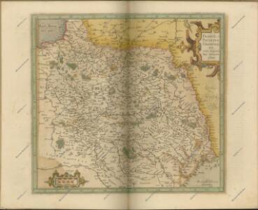
Provinciae Belgii regii
1 : 760000 Belgie Danckerts, Justus Iusto Danckerts
PROVINCIAE BELGII REGII
1 : 760000 Belgie Danckerts, Justus Iusto Danckerts
Carte de la république de France, no. 2
1 Blatt : 41 x 58 cm s.n.
Geologische Profile von Deutschland im Allgemeinen.
1 : 3870000 Berghaus, Heinrich