Maps of Centru


Novaja karta naměstničestv / Soč. J. Treskot
1 : 10900000 1 Karte : Kupferdruck ; 30 x 19 cm Truskot, Ivan Fomič [Verlag nicht ermittelbar]
Gouv. 34. Wilna, 35. Grodno, 36. Bialystock
1 : 2300000 1 Karte : Lithographie ; 26 x 19 cm Schlieben, W.E.A. von [Georg Joachim Göschen]
Generalkarte Des Russischen Reichs mit der Eintheilung in die neu errichteten Statthalterschaften un
1 : 5600000 1 Karte auf 3 Blatt : Kupferdruck ; 79 x 171 cm ; Einzelbl. 79 x 57 cm Schraembl, Franz Anton Zu finden im eigenen Verlage in Wien
Partie septentrio.le et meridionale de la Russie européenne Tartarie russienne et Petite Tartarie
1 : 13000000 1 Karte : Kupferdruck ; 23 x 21 cm [Collége de Maître-Gervais]
Principatus Valachiae, Moldaviae, et Transylvaniae, divisus in singulares Populos cum finitimis Regionibus distinete ostenduntur
1 : 1100000 Mollova mapová sbírka Valk, Gerhard Valck, Gerard
Austrian Dominions II.
1 : 1760000 Society for the Diffusion of Useful Knowledge (Great Britain)
Black Sea / the illustrations drawn & engraved by H. Winkles ; the map drawn & engraved by J. Rapkin
1 : 6336000 1 Karte : Kupferdruck ; 23 x 31 cm Winkles, Henry The London Printing and Publishing Company
Austrian Empire 2.
1 : 1774080 Letts, Son & Co.
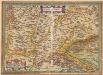
Carte de la Transilvanie

Europaeisches Russland
1 : 18000000 1 Karte : Lithogr. (mehrfarb.) ; 22 x 19 cm Sydow, Emil von Justus Perthes
Partie méridionale de la Russie d'Europe / gravé par Chamouin ; ecrit par Giraldon
1 : 8000000 1 Karte : Kupferdruck ; 21 x 29 cm Chamouin, Jean Baptiste Marie [Verlag nicht ermittelbar]
Principauté De Transilvanie Divisée en Cinq Nations, Subdivisée en Quartiersa et Comtez [Karte], in: Atlas nouveau, contenant toutes les parties du monde [...], Bd. 2, S. 199.
1 Karte aus Atlas Sanson, Nicolas Jaillot, Alexis Hubert und Mortier, Pieter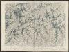
Transylvania Sibenburgen. [Karte], in: Theatrum orbis terrarum, sive, Atlas novus, Bd. 1, S. 108.
1 Karte aus Atlas Blaeu, Joan Blaeu, Willem Janszoon
Rumänien
1 : 4000000 Rumänien Weltkrieg <1914-1918>
L'Empire d'Autriche
Nouvel atlas physique politique et historique de l'Empire ottoman et des états limitrophes en Europe, en Asie et en Afrique, en quarante feuilles Hellert, J.J. Bellizard, Dufour et Cie
(Europaischen Turkei) 2.
1 : 1580000 Berghaus, Heinrich; Flemming, Carl; Handtke, Friedrich H.; Sohr, Karl
Transylvaniae Principatus in quinque nationes divisus : longitudine 68 milliaria German. et latitudine 50 mill. complectens
1 : 750000 juxta recentiss. designationem accuratissime aeri incisus per Matthaeum Seutter [Aug. Vindel.] : M. Seutter
Hvngaria cvm adiacentibvs Provinciis nova et accuratiori forma exhibetur
1 : 1500000 Mollova mapová sbírka Weigel, Christoph Weigel, Christoph I.
Transilvania [Karte], in: Theatrum orbis terrarum, S. 271.
1 Karte aus Atlas Ortelius, Abraham
Transylvania Sibenburgen. [Karte], in: Novus Atlas, das ist, Weltbeschreibung, Bd. 1, S. 201.
1 Karte aus Atlas Blaeu, Joan Blaeu, Willem Janszoon
Transylvania [Karte], in: Atlas, sive, Cosmographicae meditationes de fabrica mundi et fabricati figura, S. 159.
1 Karte aus Atlas Mercator, Gerhard
Transylvania
Transsylvania XXI. Nova Tabula. [Karte], in: Claud. Ptolemaeus. Geographia lat. cum mappis [...], S. 425.
1 Karte aus Atlas Münster, Sebastian [und Ptolemaeus, Claudius]
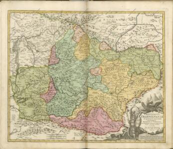
Principatus Transilvaniae in suas quasque nationes earumque sedes et regiones
1 : 705000 Rumunsko Homann, Johann Baptist J. B. Homann
Principatus Transilvaniae in suas quasque nationes earumque sedes et regiones
1 : 688000 Sedmihradsko (Rumunsko) Homann, Johann Baptist operá Ioh. Baptistae Homanni
PRINCIPATUS TRANSILVANIAE IN SUAS QUASQUE NATIONES earumque SEDES ET REGIONES
1 : 705000 Sedmihradsko (Rumunsko) Homann, Johann Baptist operâ Ioh. Baptistae Homanni