Maps of Polynesia


America
1 : 40000000 Amerika Schmidt, Johann Marius Friedrich T. Mollo
Westliche Halbkugel.
1 : 100000000 Flemming, Carl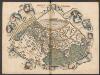
Generale Ptholemei [Karte], in: Claudii Ptolemei viri Alexandrini mathematice discipline philosophi doctissimi geographie opus [...], S. 148.
1 Karte aus Atlas Waldseemüller, Martin [und Ptolemaeus, Claudius] Übelin, Georg
Walker's Geographical Pastime.
1 : 48000000 Walker, John
OEstliche Halbkugel
Afrika
Westliche Halbkugel
Amerika
Westliche Halbkugel
Amerika
Tabv Gran Rvssie / diefert sitvs orbis hydrographorvm ab eo qvem Ptolomevs posvit
1 : 39000000 1 Karte : Holzschnitt ; 28 x 45 cm Ptolemaeus, Claudius [Lorenz Fries]
Orbis Terrarum Veteribus Cogniti Typus Geographicus. [Karte], in: Novus atlas absolutissimus, Bd. 10, S. 8.
1 Karte aus Atlas Janssonius Offizin
W. Hemisphere.
1 : 51000000 Hall, S. (Sidney)
Eastern Hemisphere.
1 : 57000000 Sharpe, J.
America.
1 : 55000000 Reichard, C. G.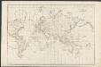
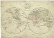
Allgemeine Weltcharte
1 : 45400000 nach Mercators Projection entworfen von A.I. Krusenstern, Capitain der Russischen Marine J. Walker sculpt. ; verb. bis zum Jahre 1818. London : [s.n.]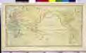
CHART of the WORLD

Karte von der Erde oestlicher und westlicher Halbkugel
země světa Reilly, Franz Johann Josef von Alberti, Ignaz von Franz Ioh. Ios. von Reilly
Orbis terrae compendiosa descriptio
země světa Mercator, Rumold Porro, Girolamo Rumoldus Mercator
[Zoological Geography, Geographical Division & Distribution of Rodentia (Gnawing Animals)]
The physical atlas Johnston, Alexander Keith William Blackwood & Sons
Hydrographical chart of the world on Wright or Mercator projection
země světa Thomson, John Scott, R.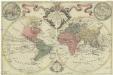
Mappa totius mundi
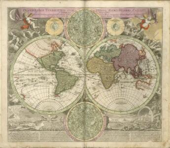
země světa Delisle, Guillaume Lotter, Tobias Conrad apud Tobiam Conradum Lotter
Resource-Relief Maps of: Europe and Australia.
Hammond, C.S.
Orbis veteribus notus
1 : 92500000 Afrika Meyer, Joseph Bibliographisches Institut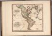
America.
1 : 44000000 Tanner, Henry S.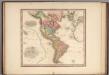
America.
1 : 44000000 Tanner, Henry S.
America.
1 : 44000000 Tanner, Henry S.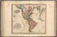
America.
1 : 44000000 Tanner, Henry S.
W. Hemisphere.
1 : 120000000 Darton, William
[Zoological Geography, Geographical Division and Distribution of the Birds of Europe]
The physical atlas Johnston, Alexander Keith William Blackwood & Sons
Oestliche Halb-Kugel
Afrika Anville, Jean-Baptiste Bourguinon d' Amon, Anton F.A. Schrämbl
Oestliche Halb-Kugel
Afrika Anville, Jean-Baptiste Bourguinon d' Amon, Anton F.A. Schrämbl