Maps of Al Hudaydah

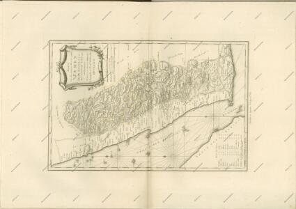
Terrae Yemen maxima pars, seu imperii Imami, principatus Kaukebân, nec non ditionum Haschid u Bekîl, Nehhm, Chaulân, Abu Arîsch et Aden, tabula : ex observationibus astronomicis et hodometricis jussu et sumtibus potentissimor. Daniae regum Friderici V, et Christiani VII. institutis, delineata
1 : 1200000 auctore C. Niebuhr Gustav Conrad Lotter sculps. Aug. Vind. : Tob. Conr: Lotter geogr. excud.
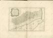
Karte von dem groessten Theil des Landes Jemen Imame, Kaukeban &
1 : 775000 Jemen Niebuhr, Carsten Benedicti, Hieronymus F.A. Schraembl
Terrae Yemen maxima Pars. seu Imperii Imami, Principatus Kaukebân, nec non ditionum Haschid U Bekîl, Nehhm, Chaulân, Abu Arîsch Et Aden Tabula : ex observationibus astronomicis et hodometricis jussu et suntibus Potentissimor: Daniae Regnum Friderici V et Christiani VII institutis
1 : 1250000 Niebuhr, Carsten, 1733-1815 Tob. Conr. Lotter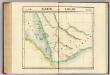
Partie, l'Arabie. Asie 100.
1 : 1641836 Vandermaelen, Philippe, 1795-1869
Fünf Karten zu C. Ritter ́s Erdkunde von Arabien
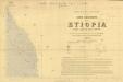
Carta dimostrativa della Etiopia (Sheet 1)
Carta dimostrativa della Etiopia, in 6 fogli e 2 aggiunte, alla scala di 1 : 100,000. Compilata dal Capitano ... Ethiopia de Chaurand, etc. [Rome]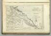
Map of Abyssinia.
1 : 1470000 Melish, John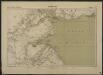
Carte de la côte française des Somalis et régions avoisinantes. Djibouti
1 : 500000 Meunier, A., cartographe [Paris] : Service géographique des colonies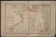
Port d'Obock et possessions françaises sur la mer Rouge
1 : 700000 Paris : Charles Bayle et Cie
Carta della colonia Eritrea coll'Abissinia : e regioni limitrofe tra il Nilo, Suakin e il Golfo d'Aden
1 : 4000000 Cora, Guido, 1851-1917 Fratelli Bocca
Terrae Yemen
1 : 1130000 Jemen Niebuhr, Carsten Lotter, Gustav Konrad Tob. Conr. Lotter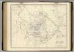
Nubia, Abyssinia.
1 : 2854868 Johnston, Alexander Keith, 1804-1871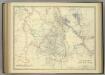
Upper Nubia and Abyssinia.
1 : 2854868 Johnston, Alexander Keith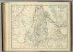
Upper Nubia and Abyssinia.
1 : 2854868 Johnston, W. & A.K.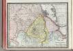
Upper Nubia and Habesh or Abyssina.
1 : 5000000 Rand McNally and Company
Abyssinia, surrounding countries.
1 : 6450000 Rand McNally and Company
Ethiopia. Pergamon World Atlas.
1 : 5000000 Polish Army Topography Service
Golfe Arabique ou Mer Rouge.
1 : 3100000 Anville, Jean Baptiste Bourguignon d, 1697-1782
AEthiopisches Hochland Alpenland Habesch und Vorstuffe von Darfur und Sennaar
Dárfúr (Súdán) Arrowsmith, John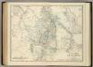
Upper Nubia and Abyssinia.
1 : 2854868 Johnston, Alexander Keith
Golfe arabique ou mer rouge
1 Karte : Kupferdruck ; 66 x 47 cm Anville s.n.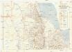
Seconda edizione della nuova carta dei domini e protettorati italiani nell' Eritrea e regioni limitrofe
1 : 1500000 Eritrea Ministero della guerra
1re partie de la Carte de la Mer Rouge
1 : 2500000 Rudé moře-oblast
Carte d'Abyssinie et des contrées adjacentes dressée partie d'après des observations faites sur les lieux par l'auteur, partie d'après les informations prises dans le pays en 1809 et 1810
1 : 5000000 par Henry Salt [S.l.] : [s.n.]
Nubia and Abyssinia to Bab El Mandeb.
1 : 3380000 Sharpe, J.
Carta della colonia Eritrea
1 : 1500000 Italie. Ministero degli Affari esteri [Florence] : Ministero degli affari esteri
Carte générale d'Abyssinie
1 : 1800000 dressée par M. le lieutenant de vaisseau Théophile Lefebvre pendant son voyage d'exploration en 1839, 40, 41, 42, 43 Paris : Arthus Bertrand
Carte der neuen Strasse von Villa de St. José do Porto-Alegre nach Minas Novas welche im Jahr 1816 durch die Wälder gebahnt ward vom Coronel Bento Lourenco Vaz de Abreu e Lima, Inspector dieser Strasse
Minas Novas (Brazílie) Kitschin, Thomas Brönner, Heinrich Ludwig Heinrich Ludwig Brönner