Maps of Languedoc-Roussillon
Sixieme feuille contenant le Languedoc, le Dauphiné, la Provence et le Roussillon
1 Blatt : 38 x 55 cm Bourgoin
Neueste Generalkarte von Frankreich, 6
1 Blatt : 55 x 78 cm F.A. Schrämbl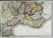
Carte de la république de France, no. 6
1 Blatt : 42 x 58 cm s.n.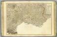
SE France.
1 : 700000 Faden, William, 1750?-1836
France Flle. S.E.
1 : 1000000 Vivien St Martin, L.
Postkarte von Frankreichs südoestlichen Departements oder von Languedoc, Provence, Delphinat und Savoyen
Dauphiné (Francie) Müller, Franz im von Reillyschen Landkarten und Kunstwerke Verschleiss Komptoir
Carte de la France (SE)
1 : 345600 Cassini family
France - south-eastern section; Corsica; Marseille.
1 : 1000000 John Bartholomew & Co.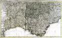
La basse partie du gouvernement de Languedoc
1 Karte auf 2 Blättern : Kupferdruck ; 49 x 85 cm Allard; Anse chez Charles Allard sur le Dam
Gouvernements de Languedoc, de Roussillon, et de Foix
1 : 1480000 Foix (Francie) Bonne, Rigobert André
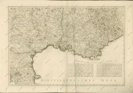
Pars inferior principatus Languedoci, Provinciae, Delphinatus, Tractus Lugdunensis, Aquitaniae, et Vasconiae, cum descriptione limitum principat. Pedemontii; comitus Nicae, et ducatus Montferatensis
1 : 740000 novissime in lucem emissa, apud Petrum Schenk [Amsterdam] : apud Petrum Schenk
Karte von Frankreich in XVI Blättern, No. 11 und [No. 15]
2 Blätter : 52 x 34 cm Königl. Preuss. Academischen Kunst und Buchhandlung
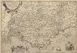
Le gouvernement general de Languedoc divisé en trois lieutenances generales
1 Karte : Kupferdruck ; 44 x 60 cm Nolin; Du Tralage chez I. B. Nolin sur le quay de l'Horloge du Palais a l'enseigne de la place des Victoires vers le Pont Neuf
Le gouvernement general de Languedoc divisé en trois lieutenances generales, scavoir La I. Lieutenance Grle. de Haut Languedoc qui comprend les Dioceses de Montauban, Alby, Castres, Lavaur, Carcaßonne, St. Papoul, Mirepoix, Rieux et Thoulouse
1 : 820000 dressez sur les Memoires du Sr. Tillemon, par J. B. Nolin A Paris : chez J. B. Nolin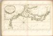

Provincia [...] Provence. [Karte], in: Le théâtre du monde, ou, Nouvel atlas contenant les chartes et descriptions de tous les païs de la terre, Bd. 2, S. 152.
1 Karte aus Atlas Blaeu, Willem Janszoon und Blaeu, Joan Blaeu, Willem Janszoon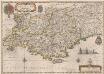
Provincia [...] Provence. [Karte], in: Theatrum orbis terrarum, sive, Atlas novus, Bd. 2, S. 140.
1 Karte aus Atlas Blaeu, Joan Blaeu, Willem Janszoon
Franzosische Mittelmeerkuste, Paris, untere Seine.
1 : 1500000 Andree, Richard
Provinciae, regionis Galliae, vera exactissimaque descriptio
1 : 234000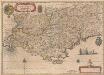
Provincia [...] Provence. [Karte], in: Novus Atlas, das ist, Weltbeschreibung, Bd. 2, S. 153.
1 Karte aus Atlas Blaeu, Joan Blaeu, Willem Janszoon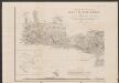
Provinciae, Regionis Galliae, vera exactissimaque descriptio. [Karte], in: Gerardi Mercatoris Atlas, sive, Cosmographicae meditationes de fabrica mundi et fabricati figura, S. 229.
1 Karte aus Atlas Mercator, Gerhard Montanus, Petrus
PROVINCIA. = PROVENCE
Auctore Petro Joanne Bompario. Amsterdami | Apud Guiljelmum Iansonium | et Johannem Blaeu.
Carte de France, 11
2 Blätter : Kupferdruck ; 53 x 45 cm Crepy
Provinciae, Regionis Galliae, vera exactissimaque descriptio. [Karte], in: Theatrum orbis terrarum, S. 143.
1 Karte aus Atlas Ortelius, Abraham Vrients, Jan Baptista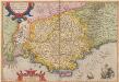
Provinciae, Regionis Galliae, vera exactissimaque descriptio. [Karte], in: Theatrum orbis terrarum, S. 86.
1 Karte aus Atlas Ortelius, Abraham
Galliae Narbonensis Ora Marittima Recenter descripta. [Karte], in: Theatrum orbis terrarum, S. 37.
1 Karte aus Atlas Ortelius, Abraham
France [Mediterranean coast of]
The Mediterranean Coast of France, from the Spanish frontier to the Italian frontier. Beaches & landrings. Compiled and drawn by Inter-Service Topographical Department. G.S.G.S Misc. 50. [London] : War Office
GVBERNATIO GENERALIS LANGVEDOCIAE OCCITANIA olim dictae
1 : 670000 Languedoc (Francie) Nolin, Jean-Baptiste studio Homannianorum Heredum