Maps of Warmian-Masurian


III, uit: General-Karte von Mittel-Europa in 12 Blättern, im Masse 1:1.200.000 / entworfen, bearb. und hrsg. von Josef Schlacher
1 : 1200000 Annotatie: Blad 6 ontbreekt; Annotatie geografische gegevens: 21 maatstokken op blad 9; Legenda op blad 9 Wien : K.K. Militär Geografisches Institut
Karte von dem Koenigreiche Preussen
1 : 745000 Prusko Reilly, Franz Johann Josef von Franz Ioh. Ios. von Reilly
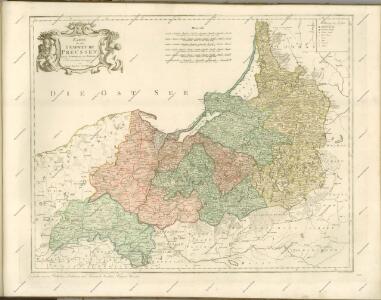
Karte von dem Koenigreiche Preussen
1 : 745000 Prusko Reilly, Franz Johann Josef von Endersch, Johann Friedrich Franz Ioh. Ios. von Reilly

Kreise der Provinz Preußen 1864
Preußen, Provinz Preußen, Verwaltungsgliederung Kunz, Andreas ; Moeschl, Joachim Robert
Prussia.
1 : 1900000 Bowen, Frances
Preussen, Ost- u. West.
1 : 1320000 Radefeld, Carl Christian Franz, 1788-1874
Ost- und Westpreussen
1 : 2250000 Ostpreußen Skizzenbuch

Friedrich I., König in Preussen. - Der deutsche Orden und die Hohenzollern
Ostpreußen, Westpreußen, ethnische Gruppe
Ost- und West-Preussen
Grosser Hand-Atlas über alle Theile der Erde in 170 Karten Meyer, J. Verlag des Bibliographischen Instituts
Ost- u. Westpreussen.
1 : 1500000 Andree, Richard
[Die Preuss: Provinzen Preussen und Posen]
Hand-Atlas über alle Theile der Erde nach dem neuesten Zustande und über das Weltgebäude Stieler, Adolf bei Justus Perthes
Regni Prussici Accuratissima Delineatio Edita Studio
Das Königreich Preussen

[Das Deutsches Reich, Blatt 2]
Adolf Stieler's Handatlas über alle Theile der Erde und über das Weltgebäude Stieler, Adolf Justus Perthes
Die Provinz Preussen, bestehend aus den Regierungsbezirken Königsberg, Gumbinnen, Danzig & Marienwerder
1 : 1850000 Provinz Preußen
Royaume de Prusse
1 : 1640000 Prusko Bonne, Rigobert André
Borussiae regnum cum adjacentibus regionibus mappa geographica delineat
1 : 1760000 Neuchâtel (Švýcarsko) Seutter, Matthäus Silbereisen, Andreas T.C. Lotter

Karte der Eisenbahnen Deutschlands
1 : 700000 Nordost-Blatt Stich, Druck u. Verlag des lithographischen Instituts von Aug. Wehrt
REGNI PRUSSIAE accurata delineatio
1 : 2500000 Prusko
Pommern und Preussen
Neuer Handatlas über alle Theile der Erde Kiepert, Heinrich Verlag von Dietrich Reimer
Preussen, Posen; Russisch-Polen.
1 : 2050000 Flemming, Carl
Borussiae regnum complectens circulos Sambiensem, Natangiensem et Hockerlandiae nec non Borussia polonica, exhibens palatinatus Culmiensem, Marienburgensem, Pomerelliae et Varmae cum adjacentibus aliis provinciis mappa geographica
1 : 730000 sumtibus et curis exarata Tobiae Conradi Lotteri. Aug. Vind : [T.C. Lotter]