Maps of Landkreis Schwäbisch Hall

Maps of Landkreis Schwäbisch Hall

$title$

$title$

Suevia Universa :

1 : 170000 Mollova mapová sbírka Michal, Jacques de Seutter, Matthäus Seutter, Matthäus
$title$

Des Herzogthums Würtemberg nordöstliche Aemter mit den freyen Reichsstädten Heilbronn, Wimpfen und Eslingen

1 Karte : Kupferdruck ; 23 x 26 cm Reilly F. J. J. von Reilly
$title$

S.R.Imp. Circuli Franconici Geographica Delineatio Francken-Land mit Seinen Gräntzen

Mollova mapová sbírka Endter, Wolfgang Moritz Endter, Wolfgang Moritz
$title$

Suevia universa IX. tabulis delineata, 2

1 Blatt : s.n.
$title$

Die freye Reichsstadt Schwæbisch Hall mit ihrem Gebiethe

1 Karte : Kupferdruck ; 21 x 27 cm Reilly F. J. J. von Reilly
$title$

Comitatvs Wertheimici Finitimarvmqve Regionvm Nova et Exacta descriptio

1 : 110000 Mollova mapová sbírka Valk, Gerhard Schenk, Peter I
$title$

Comitatvs Wertheimici Finitimarvmqve Regionvm Nova et Exacta descriptio

1 : 110000 Mollova mapová sbírka Janssonius, Johannes Janssonius, Johannes I
$title$

Geographica Provinciarum Sveviae Descriptio :

Mollova mapová sbírka Hurter, Johann Christoph Küsel, Melchior Bodenehr, Johann Georg
$title$

Geographica Provinciarum Sveviae Descriptio =

Mollova mapová sbírka Hurter, Johann Christoph Bodenehr, Gabriel
$title$

Tabula geographica sistens territorivm liberæ sacri romani imperii civitatis Svevo=Hallensis

1 Karte : Kupferdruck ; 45 x 54 cm Cnopf Homännische Erben
$title$

Charte von dem Fürstenthum Hohenlohe, und der Grafschafft Limpurg

1 : 150000 Hohenlohe (Německo) Hammer, C.F.
$title$

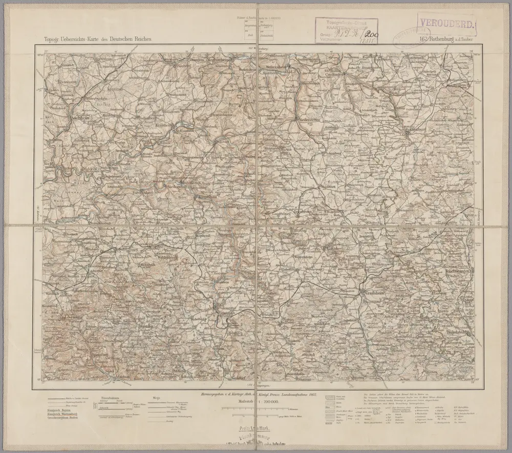
162. Rothenburg a.d. Thauber, uit: Topographische Uebersichtskarte des Deutschen Reiches / herausgegeben v. d. Kartogr. Abt. d. Königl. Preuß. Landesaufnahme

1 : 200000 titelvariant: Topogr. Übersichtskarte des Deutschen Reiches; Annotatie: Titel boven bladen ook: Topogr. Übersichtskarte des Deutschen Reiches; Annotatie geografische gegevens: Op elk blad twee maatstokken: 10 Kilometer = 5,5 cm; 1 geogr. Meile = 3,6 cm; Legenda onder op elk blad Königlich Preußische Landesaufnahme. Kartographische Abtheilung [S.l : Königlich Preußische Landesaufnahme, Kartographische Abtheilung]
$title$

Geographica Provinciarum Sveviae Descriptio =

Mollova mapová sbírka Hurter, Johann Christoph Bodenehr, Gabriel
$title$

Geographica Provinciarum Sveviae Descriptio =

Mollova mapová sbírka Hurter, Johann Christoph Bodenehr, Johann Georg
$title$

Tabula Geographica sistens Territorivm Liberae Sacri Romani Imperii Civitatis Svevo-Hallensis

1 : 85000 Mollova mapová sbírka Cnopf, Matthäus Ferdinand Homann, Johann Baptista - dědici
$title$

Comitatus Limpvrgensis Mandato Speciali imperatium mensuratus & hac Tabula geographica comprehensus In lucem prodit Curis

1 : 70000 Mollova mapová sbírka Homann, Johann Baptist Homann, Johann Baptista - dědici
$title$

$title$

Die Freye Reichsstadt Schwaebisch Hall mit ihrem Gebiethe : Nro. 190

Reilly, Franz Johann Joseph von
$title$

$title$

Novissima et accurata Tabula Geographica Principalis S. R. I. Praepositurae Ellevacensis

1 : 95000 Mollova mapová sbírka Seutter, Matthäus Seutter, Matthäus
$title$

Novissima et accurata tabula geographica principalis S.R.I. praepositurae Ellevacensis cum suis praefecturis atque locis eo pertinentibus

1 : 100000 à Matthaeo Seuttero Tob. Conr. Lotter sc. Aug. Vind : [Seutter]
$title$

Novissima et accurata tabula geographica principalis S. R. I. præposituræ Ellevacensis

1 Karte : Kupferdruck, 48 x 56 cm Seutter; Lotter Matthäus Seutter
$title$

Les environs d'Hailbron

1 Karte : Kupferdruck ; 23 x 29 cm Nolin chez I. B. Nolin sur le quay de l'Horloge du Palais
$title$

Karte der Umgegend von Stuttgart

1 : 70000 Stuttgart-oblast (Německo) Hoffmann, Carl Carl Hoffmann
$title$

Aalen, Albuch a okolí]

Mollova mapová sbírka Bodenehr, Gabriel Bodenehr, Gabriel
$title$

Gegend des Neckar-Stroms von Lauffen bis Wimpfen mit den Campements der Teutschen 1693 u. A. 1734

Mollova mapová sbírka Riecke, Gustav Friedrich Homann, Johann Baptista - dědici
$title$

Plan Von den Beyden Campements wie die hohe Allierte Kaÿserliche Reichs-Armée bey der Stadt Heilbronn Anno 1693 und Anno 1734 im Lager gestanden

Mollova mapová sbírka Riecke, Gustav Friedrich Bodenehr, Gabriel
$title$

Meßtischblatt [7226] : Oberkochen, 1927

1 : 250000 Oberkochen. - 1:25000. - Stuttgart, 1927. - 1 Kt.
$title$

Meßtischblatt [7225] : Heubach, 1928

1 : 250000 Heubach. - 1:25000. - Stuttgart, 1928. - 1 Kt.
© MapTiler © OpenStreetMap contributors
How does it work?
These instructions will show you how to find historical maps online.
Getting started
Type the place name in the search box to find the exact location. You can further adjust the search by zooming in and out.
Zoom
Zoom in and out with the buttons or use your mouse or touchpad natively.
Exact Area tool
Click here and draw a rectangle over the map to precisely define the search area.
Set filters
Narrow your search with advanced settings, such as Years (from/to), Fulltext, Publisher, etc.
Results
See the results of your search on the right side. You can scroll down to find more maps of this location.
?

Download OldMapsOnline Mobile