Maps of Tongeren
[114][117] Tabula Ducatus Limburch. et Comitatus Valckenburgh., uit: Atlas sive Descriptio terrarum orbis
Annotatie: Gedigitaliseerde versie. Amsterdam. Heiloo : Picturae (vervaardiger), 2015. tiff-bestand. Gedigitaliseerd: 07-01-2015; Origineel: Universiteitsbibliotheek Vrije Universiteit (XL.05127.-) ; Netherlands; Titelpagina ontbreekt Wit, Frederik de Amsterdam : Frederick de Wit
Limburgi Ducatus et Comitatus Valckenburgi nova descriptio / per N. Visscher
1 : 110000 Annotatie: Origineel is Blad 38 in atlas factice; Annotatie geografische gegevens: Noordwest boven; Met 2 schaalstokken Nicolaes Jansz Visscher sr 1618-1679 [Amsterdam : N. Visscher]
Limburgi Ducatus et Comitatus Valckenburgi Nova Descriptio [Karte], in: Novus atlas absolutissimus, Bd. 3, S. 70.
1 Karte aus Atlas Janssonius Offizin

Limburgensis ducatus nova descriptio
1 : 220000 Limbursko Martini, Aegidius Visscher, Nicolaus CI Visscher
Tabula Ducatus Limburch, et Comitatus Valckenburch
1 : 125000 in lucem edita a F. De Wit. Amsterdam : by I. Cóvens en C. Mortier
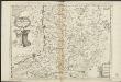
DVCATVS | LIMBVRGVM
Auctore | ÆGIDIO MARTINI. Amsterdami | Apud Guiljelmum et Joannem Blaeu
DVCATVS | LIMBVRGVM
Auctore | ÆGIDIO MARTINI. Amsterdami | Apud Guiljelmum et Joannem Blaeu
122. Aachen, uit: Topographische Uebersichtskarte des Deutschen Reiches / herausgegeben v. d. Kartogr. Abt. d. Königl. Preuß. Landesaufnahme
1 : 200000 titelvariant: Topogr. Übersichtskarte des Deutschen Reiches; Annotatie: Titel boven bladen ook: Topogr. Übersichtskarte des Deutschen Reiches; Annotatie geografische gegevens: Op elk blad twee maatstokken: 10 Kilometer = 5,5 cm; 1 geogr. Meile = 3,6 cm; Legenda onder op elk blad Königlich Preußische Landesaufnahme. Kartographische Abtheilung [S.l : Königlich Preußische Landesaufnahme, Kartographische Abtheilung]
Dvcatvs Limbvrgvm
1 : 180000 Mollova mapová sbírka Martini, Aegidius Schenk, Peter I
Dvcatvs Limbvrgvm
1 : 266000 Mollova mapová sbírka Merian, Matthaeus Merian, Matthäus
Dvcatvs Limbvrgvm
1 : 180000 Mollova mapová sbírka Martini, Aegidius Blaeu, Joan I.
Dvcatvs Limbvrgvm
1 : 175000 Mollova mapová sbírka Martini, Aegidius
Le Limbourg ou sont Le Duché de Limbourg Le Comté de Dalem, Les Seigneuries de Fauquemont et de Rolduc
1 : 180000 Mollova mapová sbírka Sanson, Guillaume Jaillot, Alexis Hubert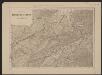
Ducatus Limburg. [Karte], in: Gerardi Mercatoris et I. Hondii Newer Atlas, oder, Grosses Weltbuch, Bd. 1, S. 401.
1 Karte aus Atlas Mercator, Gerhard und Hondius, Jodocus Jansson, Jan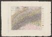
Ducatus Limburgum [Karte], in: Le théâtre du monde, ou, Nouvel atlas contenant les chartes et descriptions de tous les païs de la terre, Bd. 1, S. 363.
1 Karte aus Atlas Blaeu, Willem Janszoon und Blaeu, Joan Blaeu, Willem Janszoon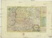
Das Herzogthum Limburg
1 : 380000 Limbursko Schreiber, Johann Georg bey Joh. Georg. Schreibern
Ducatus Limburgum [Karte], in: Novus Atlas, das ist, Weltbeschreibung, Bd. 1, S. 336.
1 Karte aus Atlas Blaeu, Joan Blaeu, Willem Janszoon
Ducea di Limburgo
1 : 200000 [Vincenzo Coronelli] [S.l.] : [s.n.]
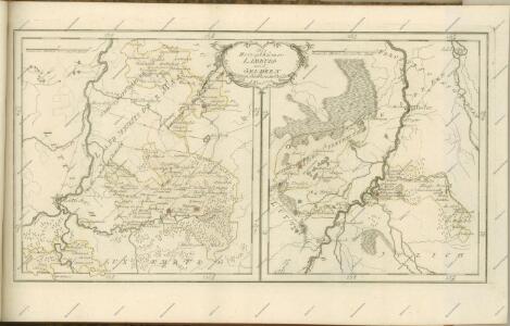
De klassis van Maastricht en landen van Overmaas
1 : 180000 door W.A. Bachiene ... J. van Jagen sculp. 1768. te Amsterdam : by D. onder de Linden
LIMBURGI Ducatus et Comitatus Nova Descriptio
1 : 110000 Limburg (Belgie : provincie) Visscher, Nicolaus per N. Visscher
Limburgi Ducatus et Comitatus Valckenburgi Nova Descriptio
1 : 110000 Mollova mapová sbírka Visscher, Nicolaes Schenk, Peter II
Tabula Ducatus Limburch et Comitatus Valckenburch in Lucem edita
1 : 120000 Mollova mapová sbírka Wit, Frederik de Wit, Frederick
Plan du chemin de fer compris entre Liège et Aix-la-Chapelle
1 : 100000 Etablissement géographique
Nieuwe en naauwkeurige kaart van de drie landen van Overmaaze, Valkenburg, Daalhem en 's Hertogenrade
1 : 200000 J. Keyser schulp. 1739. te Amsterdam : by Isaak Tirion
Carte Particuliere des environs de Maestricht Partie de Liege, Faucquemont, et Pays d'Outre-Meuse
1 : 116600 Mollova mapová sbírka Fricx, Eugène Henry Harrewyn, Jacques Fricx, Eugené Henry
Carte Particuliere des Environs de Maestricht, Partie de Liege Faucquemont, et Pays d'Outre-Meuse
1 : 250000 Mollova mapová sbírka Seutter, Matthäus Lotter, Tobias Conrad Seutter, Matthäus