Maps of Cuneo


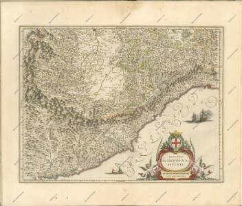
Riviera Di Genova Da Ponente [Karte], in: Novus Atlas, das ist, Weltbeschreibung, Bd. 3, S. 60.
1 Karte aus Atlas Blaeu, Joan Blaeu, Willem Janszoon
Riviera di Genova di Ponente
1 : 400000 Annotatie: In tegenstelling tot eerdere uitgaven van Johannes Janssonius bevat deze kaart een afwijkend cartouche in de vorm van een afbeelding van Neptunus geflankeerd door paarden en putti, waarbij 1 van de putti een banier vasthoudt met daarop de titel van de kaart; In tegenstelling tot latere uitgaven door Schenk & Valk ontbreekt de kompasroos en het impressum van Schenk en Valk; Origineel is Blad 156 in atlas factice; Annotatie geografische gegevens: Schaalstokken op de kaart: 10 milliaria Italica communia (= 4,1 cm) en: 2 mill. Ger. communia (= 3,6 cm) [S.l.] : [s.n.]
Riviera Di Genova Di Ponente [Karte], in: Novus atlas absolutissimus, Bd. 5, S. 99.
1 Karte aus Atlas Janssonius Offizin
Riviera Di Genova Da Ponente [Karte], in: Le théâtre du monde, ou, Nouvel atlas contenant les chartes et descriptions de tous les païs de la terre, Bd. 3, S. 48.
1 Karte aus Atlas Blaeu, Willem Janszoon und Blaeu, Joan Blaeu, Willem Janszoon
RIVIERA | DI GENOVA DA | PONENTE
[Amsterdam : Joan Blaeu]
Riviera Di Genova Da Ponente [Karte], in: Theatrum orbis terrarum, sive, Atlas novus, Bd. 3, S. 52.
1 Karte aus Atlas Blaeu, Joan Blaeu, Willem Janszoon
Principatus Pedemontii, Ducatus Augustæ Prætoriæ, Salutii Marchionatus, Astæ, Vercellarum Et Niceæ Comitatus Nova Tabula
1 : 450000 Annotatie: Kaart uitgegeven tussen [ca. 1646-ca. 1680]; Origineel is Blad 154 in atlas factice; Annotatie geografische gegevens: Schaalstokken op de kaart: 15 Milliaria Italica communia (= 4,7 cm), en: 4 Milliaria Germanica communia (= 5,5 cm); West boven; Kaart geeft de regio Piemonte weer, m.n. het gebied rondom Turijn Amstelodami : Ioannes Janßonius exeudit
Riuiera di Genova da Ponente
1 : 450000 Mollova mapová sbírka Magini, Giovanni Antonio Wright, Benjamin Magini, Fabio
Partie Meridionale du Piemont et du Monferrat
1 : 270000 Mollova mapová sbírka Delisle, Guillaume Desrosiers, F. L'Isle, Guillaume de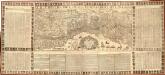
Le Due Riviere Di Genoua Con Il Oro Confini cauate dalle Relazioni di molti Virtuosidi questa Serma. domina. da Ludco. della Spina Prof. di Geogr
1 : 320000 Mollova mapová sbírka Lépine, Louis de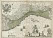
La Republique de Genes.
1 : 610000 Mollova mapová sbírka Blaeu, Willem Janszoon Covens, Johannes I
Topographia de la Liguria
1 : 170000 Mollova mapová sbírka Chafrion, José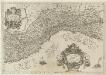
Ligvria Ò Stato Della Republica di Genoua
1 : 650000 Mollova mapová sbírka Magini, Fabio Magini, Fabio
Estats du Duc de Savoye de delà des Alpes et vers l'Italie :
1 : 530000 Mollova mapová sbírka Sanson, Nicolas L'Huilier, Jan
Principatus Piemontis Pars Meridionalis
1 : 490000 Mollova mapová sbírka Homann, Johann Baptist Homann, Johann Baptista
Piemont, Monferrat meridionale.
1 : 275000 L'Isle, Guillaume de, 1675-1726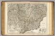
Piemont, Monferrat meridionale.
1 : 275000 L'Isle, Guillaume de, 1675-1726
Nouvelle carte de l'etat de la republique de Genes
1 : 617000 Bastia (Francie) Ottens, Josua R. et I. Ottens
Carta geographica, la quale rappresenta lo stato della republica di Genova, partita nella Riviera di Levante et di Ponente
Janov (Itálie) per gli Heredi d'Homann.

Pedemontanae vicinorvmqve regionvm
1 Karte : Kupferdruck ; 36 x 49 cm Gastaldi; Ortelius s.n.
Pedemontanae vicinorvmqve regionvm
1 Karte : Kupferdruck ; 36 x 49 cm Gastaldi; Ortelius s.n.

MAPPA GEOGRAPHICA STATVS GENVENSIS
1 : 460000 Janov-oblast (Itálie) Mayer, Tobias Chafrion, José in lucem proferentibus Homannianis Heredibvs
MAPPA GEOGRAPHICA STATVS GENVENSIS
1 : 460000 Janov-oblast (Itálie) Mayer, Tobias Chafrion, José in lucem proferentibus Homannianis Heredibvs
Lo Stato della Repubblica di Genova
1 : 400000 giusta la di lui divisione in contorno orientale et occidentale geograficamente rappresentato et di nuovo dato in luce da Tobia Cunrado Lottero Augusta : [Tobias Conrad Lotter]
Karte von dem Herzogthume Savoyen und den Grafschaften Nizza, Tenda und Boglio oder den Ländern welche der König. von Sardinien in dem Frieden zu Paris den 15 May 1796 der Französischen Republik abtrat
1 : 421000 Nice (Francie) Reilly, Franz Johann Josef von F.I.I. von Reilly
S. Remo - Ospedaletti - Bordighera
1 : 200000 Janov (Itálie) Ente nazionale per le industrie turistiche ferrovie dello stato