Maps of Piedmont


United States.
1 : 3380000 Sharpe, J.
To the members of the Nautical Institution and Ship-masters' Society of the city of New York, this chart, extending from lat. 40o 15' N., long. 72o 15' W., to lat. 22o 35' N., long. 80o 25' W., is respectfully dedicated / by their obedient servant Edmund M. Blunt; plans engraved by Hooker, N. York.
from Charts and maps Hooker, William; Edmund M. Blunt,
Lloyd's Map of the Southern States
Lloyd's Map of the Southern States showing all the Railroads, their Stations and Distances, also the Counties, Towns, Villages, Harbors, Rivers & Forts. This map was published by J.T. Lloyd in New York in 1861. It details ‘all the railroads, their stations & distances’, as well as the ‘counties, towns, villages, harbors, rivers and forts’ based on the ‘latest Government and other reliable sources’. The map details states beneath the Mason-Dixon line which theoretically separated the northern and southern states. As well as showing the states that made up the eastern side of the Confederacy, the map also shows the Union states of Kentucky, Maryland and Delaware, which, along with Missouri, made up the Border States. Maintaining these states within the Union was a crucial war aim for Lincoln. J.T. Lloyd
Vereinigte Staaten Von Nord-Amerika In 6 Blattern, Bl. 6.
1 : 3700000 Petermann, A.
Balloon View of the Southern States
Balloon View of the Southern States, showing in the foreground the whole territory between Baltimore and St. Louis, and extending towards the horizon to Keywest and New Orleans. This map shows the country between Baltimore, Maryland, and St. Louis, Missouri, with the eastern side of America presented on the left hand side of the map. At the top, in the horizon, the map stretches to Fort Lauderdale, Florida, and New Orleans, Louisiana. An interesting presentation of the country, this map was produced by Louis Prang in 1861 in Boston. Prang published many maps during the American Civil War. According to the description at the bottom of the map, this item was ‘a superior & truthful guide in the present war operations’. L. Prang & Co.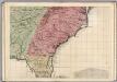
A Map of the British Empire in America. (Sheet 10).
1 : 2000000 Popple, Henry
[Die Vereinigten Staaten von Amerika in 6 Blättern, Blatt 6]
Adolf Stieler's Handatlas über alle Theile der Erde und über das Weltgebäude Stieler, Adolf Justus Perthes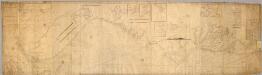
Chart, extending from 40|15' N. , 72|15' W. to 22|35" N., 80|25' W.
1 : 950000 Hooker, William
[Die Vereinigten Staaten von Nord-Amerika, Blatt 6]
Handatlas über alle Theile der Erde und über das Weltgebäude Stieler, Adolf Justus Perthes
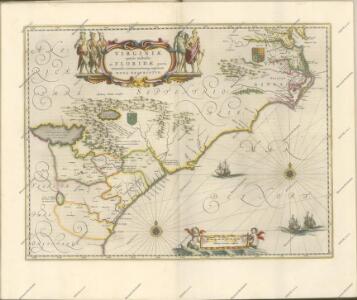
A map of Virginia and Maryland.
from Parts
County map of North Carolina, Map of South Carolina, County map of Florida ; Map of Charleston Harbor [inset].
from New general atlas.
Virginiae partis australis, et Floridae partis orientalis, interjacentiumque regionum Nova Descriptio. [Karte], in: Novus atlas absolutissimus, Bd. 6, S. 210.
1 Karte aus Atlas Janssonius Offizin
Nouvelle carte de la Caroline / par R. Morden.; L'Amerique angloise, ou Description des isles et terres du roi d'Angleterre, dans l'Amérique. Avec de nouvelles cartes de chaque isle & terres. Traduit de l'anglois.
from L'Amerique angloise, ou Description des isles et terres du roi d'Angleterre, dans l'Amérique. Avec de nouvelles cartes de chaque isle & terres. Traduit de l'anglois. Blome, Richard,
Virginiae Item et Floridae Americae Provinciarum, nova Descriptio. [Karte], in: Gerardi Mercatoris Atlas, sive, Cosmographicae meditationes de fabrica mundi et fabricati figura, S. 553.
1 Karte aus Atlas Mercator, Gerhard Montanus, Petrus
The marches of Lord Cornwallis in the Southern Provinces : now States of North America, comprehending the two Carolinas, with Virginia and Maryland, and the Delaware counties / by William Faden, geographer to the King.
from Charts and maps
VIRGINIÆ | partis australis, | et FLORIDÆ partis | orientalis, interjacentiumque regionum | NOVA DESCRIPTIO.
[Amsterdam : Joan Blaeu]
Virginiae partis australis, et Floridae partis orientalis, interiacentiumque regionum Nova Descriptio. [Karte], in: Le théâtre du monde, ou, Nouvel atlas contenant les chartes et descriptions de tous les païs de la terre, Bd. 2, S. 321.
1 Karte aus Atlas Blaeu, Willem Janszoon und Blaeu, Joan Blaeu, Willem Janszoon
Carte des Etats-unis : provinces méridionales.
from Parts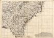
A Map of the British Empire in America. (Sheet 10).
1 : 2000000 Popple, Henry
Virginiae partis australis, et Floridae partis orientalis, interjacentiumque regionum Nova Descriptio. [Karte], in: Theatrum orbis terrarum, sive, Atlas novus, Bd. 2, S. 330.
1 Karte aus Atlas Blaeu, Joan Blaeu, Willem Janszoon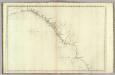
The coast of the United States from New York to St. Augustine (4th sheet)
1 : 900000 Blunt, Edmund M. (Edmund March), 1770-1862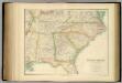
United States ... South Eastern States.
1 : 2851200 Fullarton, A. & Co.
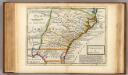
A map of those parts of Virginia, North Carolina, South Carolina & Georgia which were the scenes of the most important operations of the southern armies
from Parts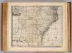
N. & S. Carolina, Georgia &c.
1 : 2900000 Bowen, Emanuel
N. & S. Carolina.
1 : 6300000 Grigg, John
The Field of Battle.
The Field of Battle and Prominent US Generals. The Field of Battle and Prominent Union Generals is one of the most picturesque maps in the collection, detailing the main theatres of conflict in the Confederacy, with each state broken up by counties, and surrounded by virtually all of the main Union Army generals that would have been well known to viewers in 1864 when this map was published in New York by Ensign & Bridgman. The generals are mostly all arranged close to the areas where they were conducting operations at the time of the map’s production, for example Generals Grant and Sherman are close to Georgia and South Carolina. Union Navy generals are also pictured, such as General David Farragut who can be seen close to the Georgia coastline. Ensign & Bridgman
A map of Virginia, North and South Carolina, Georgia, Maryland with part of New Jersey &c.
from Parts Printed for R. (Richard) Baldwin in Pater Noster Row: [London] -- Bookseller,
Soil Map of the United States, Section 8. Atlas of American Agriculture.
1 : 2500000 Marbut, Curtis F.