Maps of Andalucía


Andaluzia continens Sevillam et Cordubam. [Karte], in: Le théâtre du monde, ou, Nouvel atlas contenant les chartes et descriptions de tous les païs de la terre, Bd. 2, S. 233.
1 Karte aus Atlas Blaeu, Willem Janszoon und Blaeu, Joan Blaeu, Willem Janszoon
Andaluzia continens Sevillam et Cordubam. [Karte], in: Theatrum orbis terrarum, sive, Atlas novus, Bd. 2, S. 240.
1 Karte aus Atlas Blaeu, Joan Blaeu, Willem Janszoon
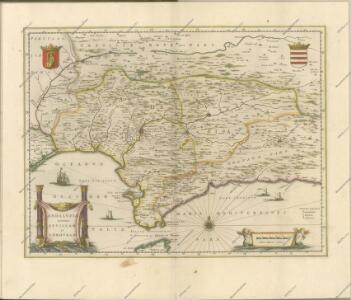
Andalvzia continens Sevillam et Cordvbam
1 Karte : Kupferdruck ; 36 x 48 cm Janssonius Joannes Janssonius
Andalvzia continens Sevillam et Cordvbam
1 Karte : Kupferdruck ; 36 x 48 cm Blaeu Joan Blaeu
Andaluzia continens Sevillam et Cordubam. [Karte], in: Novus Atlas, das ist, Weltbeschreibung, Bd. 2, S. 240.
1 Karte aus Atlas Blaeu, Joan Blaeu, Willem Janszoon
ANDALVZIA | continens | SEVILLAM | et | CORDVBAM
[Amsterdam : Joan Blaeu]
Andaluzia
1 Karte : Kupferdruck ; 17 x 24 cm Mercator; Keere Cloppenburgh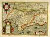
Andaluziæ nova descript
1 Karte : Kupferdruck ; 34 x 49 cm Mercator; Hondius; Hondius Henricus Hondius
Andaluziæ nova descript
1 Karte : Kupferdruck ; 34 x 49 cm Hondius; Mercator Jodocus Hondius
Andaluzia continens Sevillam et Cordubam. [Karte], in: Novus atlas absolutissimus, Bd. 6, S. 43.
1 Karte aus Atlas Janssonius Offizin
Andaluziae Nova Descript. [Karte], in: Gerardi Mercatoris et I. Hondii Newer Atlas, oder, Grosses Weltbuch, Bd. 1, S. 247.
1 Karte aus Atlas Mercator, Gerhard und Hondius, Jodocus Jansson, Jan
Andaluziae Nova Descript. [Karte], in: Gerardi Mercatoris et I. Hondii Newer Atlas, oder, Grosses Weltbuch, Bd. 2, S. 204.
1 Karte aus Atlas Mercator, Gerhard und Hondius, Jodocus Jansson, Jan
Andaluziae Nova Descript. [Karte], in: Gerardi Mercatoris Atlas, sive, Cosmographicae meditationes de fabrica mundi et fabricati figura, S. 186.
1 Karte aus Atlas Mercator, Gerhard Montanus, Petrus
Spanien Und Portugal In 4 Blattern. Blatt 3.
1 : 1500000 Vogel, C.
[Spanien und Portugal in 4 Blättern, Blatt 3]
Handatlas über alle Theile der Erde und über das Weltgebäude Stieler, Adolf Justus Perthes
Espagne et Portugal. Flle. S.O.
1 : 1250000 Vivien St Martin, L.
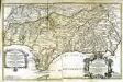
Parte meridional de las costas d'Españas
1 Karte auf 2 Blättern : Kupferdruck ; 53 x 82 cm López; Nolin; Guérard; Julien en casa de Thomas Lopez pensionista de s. m. c.a, chez le s.r Julien a l'hotel de Soubise

Regna Hispaniarum, atque Portugalliæ, 3
1 Blatt : 53 x 63 cm Gerard Valck
Andalvsia
1 Karte : Kupferdruck ; 15 x 25 cm Lambert Andreae
Li regni di Granata è d'Andalvcia / G. Cantelli da Vignola, 1
1 Blatt : Domenico de Rossi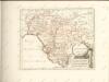

Mapa del reyno de Sevilla
1 Karte auf 4 Blättern : Kupferdruck ; 74 x 71 cm López; Ellobet s.n.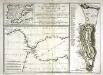
Plan géometral de la montagne et de la ville de Gibraltar
1 Plan : Kupferdruck ; 33 x 15 cm, Bildgrösse: 34 x 47 cm Bonne; Chalmandrier; Longchamps chez les Freres Barthelemy, chez le Sr. Longchamps
Sevilla regnum in suas archiepiscopatos episcopatos et praefecturas divisum
1 Karte : Kupferdruck ; 42 x 55 cm Güssefeld; López; Ellobet; Hauer Homännische Erben
Hispalensis Conventus Delineatio [Karte], in: Theatrum orbis terrarum, S. 54.
1 Karte aus Atlas Ortelius, Abraham
Hispalensis Conventus Delineatio [Karte], in: Theatrum orbis terrarum, S. 101.
1 Karte aus Atlas Ortelius, Abraham Vrients, Jan Baptista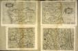
Hispalensis conventvs delineatio
1 Karte : Kupferdruck ; 14 x 18 cm Lambert Andreae