Maps of Slovenia


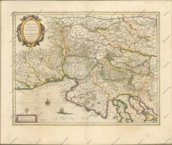
Karstia, Carniola, Histria et Windorum Marchia. [Karte], in: Novus atlas absolutissimus, Bd. 2, S. 299.
1 Karte aus Atlas Janssonius Offizin
Karstia, Carniola, Histria et Windorum Marchia. [Karte], in: Theatrum orbis terrarum, sive, Atlas novus, Bd. 1, S. 117.
1 Karte aus Atlas Blaeu, Joan Blaeu, Willem Janszoon
Karstia, Carniola, Histria et Windorum Marchia. [Karte], in: Novus Atlas, das ist, Weltbeschreibung, Bd. 1, S. 204.
1 Karte aus Atlas Blaeu, Joan Blaeu, Willem Janszoon
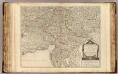
Strassen-Karte des Königreiches Illyrien
1 : 424200 Ilýrie
Karstia, Carniola, Histria et Windorum Marchia. [Karte], in: Le théâtre du monde, ou, Nouvel atlas contenant les chartes et descriptions de tous les païs de la terre, Bd. 1, S. 233.
1 Karte aus Atlas Blaeu, Willem Janszoon und Blaeu, Joan Blaeu, Willem Janszoon
Forum Iulium, Karstia, Carniola, Histria Et Windorum Marchia. [Karte], in: Gerardi Mercatoris Atlas, sive, Cosmographicae meditationes de fabrica mundi et fabricati figura, S. 450.
1 Karte aus Atlas Mercator, Gerhard Montanus, Petrus

Strassen-Karte des Königreiches Illyrien
1 : 432000 Ilýrie
Karstia, Carniola et Windorum Marchia cum confinys. Per Gerardum Mercatorem cum privilegio
1 : 750000 Krain, Istrien Mercator, Gerhard, der Jüngere
Forum Iulium, Karstia, Carniola, Histria et Windorum Marchia
1 : 750000 Krain, Windische Mark Mercator, Gerhard, der Jüngere ; Hondius, Hendrik

Partie méridionale du cercle d'Autriche qui comprend la basse partie du duché de Stirie, le duche de Carinthie, divisé en haute et basse, le duché de Carniole, divisé en haute, basse, moyenne et inter.e Carniole, et l'Istrie impériale
Kärnten, Steiermark Robert de Vaugondy, Didier
KARSTIA, | CARNIOLA,| HISTRIA | et | WINDORVM | MARCHIA
Ger. Mercatore | Auctore. Guiljelm. Blaeu | excudit
Karstia, Carniola, Histria et Windorum Marchia
Krain, Friaul Mercator, Gerhard, der Jüngere ; Blaeu, Willem Janszoon
Die Kronländer Kärnthen, Krain, Görz und Gradisca, Istrien und die reichsunmittelbare Stadt Triest nach ihrer neuesten gerichtlichen & politischen Eintheilung
Gorice a Gradiška Bermann, Joseph Joseph Bermann
Karte der Kroländer Steyermark, Kärnthen, Krain und Istrien
1 : 1530000 Istrijský poloostrov (Slovinsko a Chorvatsko) Marco Berra
Zemljovid slovenske dežele in pokrajin
Slowenien Knorr, A.
Autriche meridionale.
1 : 480000 Robert de Vaugondy, Gilles, 1688-1766
General-Karte des Königreichs Jllyrien
1 : 295000 Ilýrie im k.k. Militaerischen geographischen Institute
Königreich Illyrien
Grosser Hand-Atlas über alle Theile der Erde in 170 Karten Meyer, J. Verlag des Bibliographischen Instituts
Das Königreich Illyrien und das Herzogthum Steyermark
1 : 700000 Ilýrie Weiland, Karl Ferdinand im Verlage des geographischen Instituts
Tabula Ducatus Carnioliae Vindorum Marchiae et Histriae ex mente Illustr. mi quondam
1 : 250000 Mollova mapová sbírka Homann, Johann Baptist
Herzogthümer Steiermark, Kärnten, Krain, die gefürstete Graftschaft Görz und Gradiska, die Markgraftschaft Istrien, die Stadt Triest mit Gebiet und das ungarische Littorale
1 : 600000 Steiermark, Kärnten Gräf, Carl
Oesterr. Kronlander.
1 : 700000 Weiland, C. F. (Carl Ferdinand), d. 1847
Das Herzogth. Steiermark, das Herzogth. Kärnten, das Herzogth. Krain, das Küstenland (Triest, Görz-Gradisca, Istrien)
Štýrsko (Rakousko) Benecke Bormann, E. Ignaz Fuchs
Carte del regno d'Illiria e del ducato Stiria
1 : 860000 Ilýrie Raffelsperger, Franz nel magazeno delle carte tipografiate
Carte du royaume d'Illirie et du duché de Styrie
1 : 520000 Ilýrie Raffelsperger, Franz Rumpold, F. au Dépôt des cartes typografiées