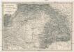
Maps of Carpathian Mountains


Die Münzkammer-Gebiete Ungarns bis 1395
Ungarn Münzwesen
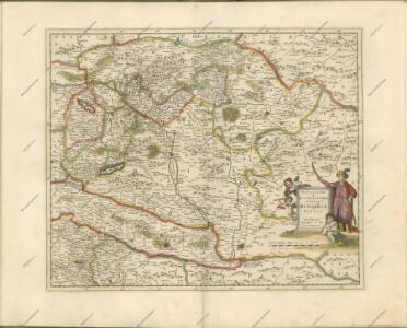
Carte Particuliere De La Hongrie De La Transilvanie De La Croatie Et De La Sclavonie
1 : 1400000 Mollova mapová sbírka Delisle, Guillaume Schenk, Peter II
Carte Particuliere De La Hongrie De La Transilvanie De La Croatie Et De La Sclavonie
1 : 1400000 Mollova mapová sbírka Delisle, Guillaume L'Isle, Guillaume de
Ungarn und ein Theil von Siebenbürgen
Stieler's Hand-Atlas Stieler, Adolf bei Justus Perthes
Ungarn und ein Theil von Siebenbürgen
Hand-Atlas über alle Theile der Erde nach dem neuesten Zustande und über das Weltgebäude Stieler, Adolf bei Justus Perthes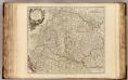
Hongrie, Transilvanie, Sclavonie, Croatie, Valaquie, Bosnie, Bulgarie.
1 : 1450000 Robert de Vaugondy, Gilles, 1688-1766
Das Königreich Ungarn nach seiner natürlichen und politischen Ansicht. Übersicht der Komitate
Ungarn Kroatien Verwaltungsbezirk Komitat
Charte von den Kaiserlich Oesterreichischen Ungarischen Ländern
1 : 1200000 entworfen u. gezeichnet von F. W. Streit Weimar : Verlag des Geograph. Instituts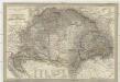
Magyar-ország
1 : 1400000 Chorvatsko Fried, Franz List, Joseph bei Artaria &. Comp.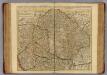
Hongrie, Transilvanie, Croatie, Sclavonie.
1 : 1390000 L'Isle, Guillaume de, 1675-1726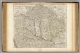
Hongrie, Transilvanie, Croatie, Sclavonie.
1 : 1390000 L'Isle, Guillaume de, 1675-1726
Allgemeine Charte vom Königreiche Ungarn
1 : 1500000 Chorvatsko Liechtenstern, Joseph Marx von Berken von Ottendorff, Johann Kunst und Industrie Comptoirs
Allgemeine Charte vom Königreiche Ungarn
1 : 1500000 Chorvatsko Liechtenstern, Joseph Marx von Berken von Ottendorff, Johann im Verlage des Kunst und Industrie Comptoirs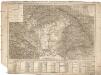
Tabula generalis regni Hungariae Croatiae et Slavoniae, nec non magni principatus Transylvaniae conspectum mappae generalis in IX. sectiones moduli majoris distributae civitates, oppida, stationes et vias postales singillatim accurateque exhibens
1 : 1396000 Chorvatsko Lipský, Ján Karacs, Ferenc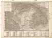
Tabula generalis regni Hungariae Croatiae et Slavoniae, nec non magni principatus Transylvaniae conspectum mappae generalis in IX. sectiones moduli majoris distributae civitates, oppida, stationes et vias postales singillatim accurateque exhibens
1 : 1400000 Chorvatsko Lipský, Ján Festetits de Tolna, Georgio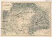
Uibersichts Karte des Kriegsschauplatzes von Ungarn und Siebenbürgen
1 : 1470000 Maďarsko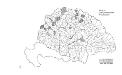
Die konservativen Wahlbezirke
Ungarn Wahlbezirk, Wahlverhalten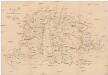
Karte des ungarischen Communikations-Netzes
1 : 1140000 Evropa jihovýchodní
Karte der Königreiche Ungarn, Croatien, Slavonien und Militärgrenzen

Regni Hungariae Delineatio
1 : 3500000 Mollova mapová sbírka Seutter, Matthäus Seutter, Matthäus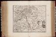
Novissima et accuratissima totius Hungariae tabula / par P. Du Val, geographe du Roij
1 : 1350000 Annotatie: Titel in het Latijn, auteursvermelding in het Frans, impressum en schaalaanduiding in het Nederlands; Origineel is Blad 131 in atlas factice; Annotatie geografische gegevens: Schaalvermelding boven schaalstok: Gemeene Duijtsche Mijlen van 15 in een graedt Pierre Du Val 1618-1683 't Amsterdam : gedruckt by Justus Danckers
Carte particuliere de la Hongrie de la Transilvanie de la Croatie et de la Sclavonie
1 : 1400000 Chorvatsko Delisle, Guillaume J. Covens et C. Mortier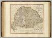
Hungary, Transylvania, Croatia.
1 : 1500000 Cary, John, ca. 1754-1835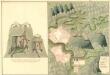
Plan der Bergstadt Terestian
Mollova mapová sbírka Geyer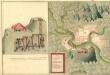
Plan des Gold und Silber Berg Adamos
Mollova mapová sbírka Geyer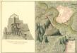
Plan der Bergstat Bogan
Mollova mapová sbírka Geyer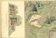
Plan der Bergstadt Abrugbania
Mollova mapová sbírka Geyer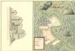
Plaan des Haupt Bergwerg Maidanpeg
Mollova mapová sbírka Geyer