Maps of Lithuania


Regni Prussici Accuratissima Delineatio Edita Studio

Borussiae regnum cum adjacentibus regionibus mappa geographica delineat
1 : 1760000 Neuchâtel (Švýcarsko) Seutter, Matthäus Silbereisen, Andreas T.C. Lotter

REGNI PRUSSIAE accurata delineatio
1 : 2500000 Prusko
Théatre de la guerre actuelle, en Allemagne, en Pologne et en Turquie. n4 (bis), Dantzig
1 : 900000 Chanlaire, Pierre Grégoire 1758-1817 Paris : chez l'auteur P. G. Chanlaire
III, uit: General-Karte von Mittel-Europa in 12 Blättern, im Masse 1:1.200.000 / entworfen, bearb. und hrsg. von Josef Schlacher
1 : 1200000 Annotatie: Blad 6 ontbreekt; Annotatie geografische gegevens: 21 maatstokken op blad 9; Legenda op blad 9 Wien : K.K. Militär Geografisches Institut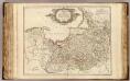
La Prusse.
1 : 720000 Robert de Vaugondy, Gilles, 1688-1766
(La Prusse)
1 : 4000000 Bruyset, Jean-Marie; Schneider, J. H.
Prussia.
1 : 1900000 Bowen, Frances

Karte der Eisenbahnen Deutschlands
1 : 700000 Nordost-Blatt Stich, Druck u. Verlag des lithographischen Instituts von Aug. Wehrt
Ost- u. Westpreussen.
1 : 1500000 Andree, Richard
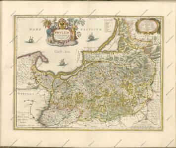
Borussiae regnum complectens circulos Sambiensem, Natangiensem et Hockerlandiae nec non Borussia Polonica exhibens palatinatus Culmiensem, Marienburgensem, Pomerelliae et Varmiae cum adjacentibus aliis provinciis
1 : 732000 Prusko Lotter, Tobias Conrad sumtibus et curis exarata Tobiae Conradi Lotteri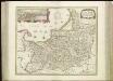
[72][72] Tabula Prussiae , uit: Atlas sive Descriptio terrarum orbis
Annotatie: Gedigitaliseerde versie. Amsterdam. Heiloo : Picturae (vervaardiger), 2015. tiff-bestand. Gedigitaliseerd: 07-01-2015; Origineel: Universiteitsbibliotheek Vrije Universiteit (XL.05127.-) ; Netherlands; Titelpagina ontbreekt Wit, Frederik de Amsterdam : Frederick de Wit
Burgen-Karte von Preussen zur Zeit Deutschen Ordens
1 : 750000 Prusko Fischer, von Herwig, C. G.
Borussiae regnum complectens circulos Sambiensem, Natangiensem et Hockerlandiae nec non Borussia polonica, exhibens palatinatus Culmiensem, Marienburgensem, Pomerelliae et Varmae cum adjacentibus aliis provinciis mappa geographica
1 : 730000 sumtibus et curis exarata Tobiae Conradi Lotteri. Aug. Vind : [T.C. Lotter]
Prussia.
1 : 1670000 Lucas, Fielding Jr.
Kreise der Provinz Preußen 1864
Preußen, Provinz Preußen, Verwaltungsgliederung Kunz, Andreas ; Moeschl, Joachim Robert

Regnum Borussiae
1 : 725500 Prusko a Ioh. Baptista Homanno
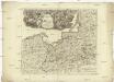
Mappa geographica Borvssiam orientalem aeqve occidentalem exacté exhibens, in qva non tantvm limites correcti, sed etiam principaliora loca, civitates et oppida secvndvm longitvdinem et latitudinem ad am vssim novissimarvm omnistudio et accuratione designata sunt
1 : 698000 Prusko Endersch, Johann Friedrich Ioh. Frideric. Endersch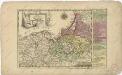
Das Königreich Preussen
Le royaume de Prusse
1 : 747000 Prusko Le Rouge, Georges-Louis Le Rouge
Preussen, Ost- u. West.
1 : 1320000 Radefeld, Carl Christian Franz, 1788-1874
Regni Borussiae secundum observationes novissima, accuratissima descriptio
1 : 750000 edita á R. & I. Ottens geogra. Amstelodami = Carte nouvelle du Royaume de Prusse / dressée sur les observations les plus nouvelles par R. & I. Ottens geogr. á Amsterdam Amstelodami : edita à R. & I. Ottens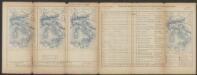
Prussia Accurate Descripta [Karte], in: Le théâtre du monde, ou, Nouvel atlas contenant les chartes et descriptions de tous les païs de la terre, Bd. 1, S. 97.
1 Karte aus Atlas Blaeu, Willem Janszoon und Blaeu, Joan Blaeu, Willem Janszoon