Maps of powiat nyski


Kladsko
1 : 200000 Kladsko-oblast (Polsko) Service cartogr. de l ́Armee Tcheco-Sl.
171 Neisse, uit: Topographische Special-Karte von Deutschland (von Central-Europa) / begründet von D.G. Reymann ; [entworfen und gezeichn. von Heinrich Berghaus... [et al.]]
1 : 200000 Annotatie: Lit.: Daniel Gottlob Reymann und die "Topographische Special-Karte von Deutschland" / von Wolfgang Scharfe, in: Kartographische Nachrichten, 39 (1989), Heft I, p. 1-10; Handgeschreven titel: Reymann's Deutschland : 24 Sectionen: Jena, Penig, Dresden, Zittau, Hirschberg, Breslau, Brieg, Andernach, Coblenz, Giessen, Fulda, Schleusingen, Plauen, Zwickau, Teplitz, Jung Bunzlau, Hohenelbe, Glatz, Neisse, Simmern, Prag, Luxemburg, Birkenfeld; Aanwezig: 23 bladen Reymann, Daniel Gottlob; Berghaus, Heinrich [Berlin : 2. Departement des Kriegsministeriums, Bureau für Plan- und Kartenzeichnung]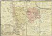
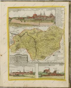
Principatvs Silesiae Mvnsterbergensis exactissima tabula geographica exhibens circulos ejusdem Mvnsterberg et Frankenstein una cum adjacentibus civitatibus Reichenstein et Silberberg ad principatum bregensem alias pertinentibus
1 : 100000 Slezsko Wieland, Johann Wolfgang Schubarth, Matthäus Homannianos Heredes
Reymann ́s Special Karte 171 Neisse
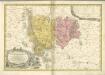
Principatvs Silesiae Mvnsterbregensis exactissima Tabula Geographica exhibens :
1 : 870000 Mollova mapová sbírka Wieland, Johann Wolfgang Homann, Johann Baptista - dědici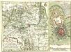
Die Gegend der Stadt und Vestung Neyss Im Herzogthum Schlesien samt denen befindlichen Orthschaften von Drey Meilen im Umcreyß
Mollova mapová sbírka Lidl, Johann Jacob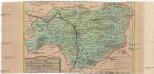
Special-Carte des Fürstenthums Grotkau oder Neisse, in Ober-Schlesien, an den böhmischen und mährische[n] Grentzen
1 : 300000 Grodków-oblast (Polsko) Wieland, Johann Wolfgang Schleuen, Johann David I.D. Schleuen
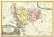
Special-Carte des Fürstenthums Grotkau oder Neisse in Ober-Schlesien, an den Böhmischen und Mährischen Grentzen
Mollova mapová sbírka Schleuen, Johann David Schleuen, Johann David
Jauernig und Weidenau.
from Spezialkarte der osterreichisch-ungarischen Monarchie.
Hotzenplotz und Zuckmantel.
from Spezialkarte der osterreichisch-ungarischen Monarchie.
Javorník
1 : 75000 Javorník (Jeseník, Česko) Vojenský zeměpisný ústav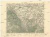
Javorník
1 : 75000 Javorník (Jeseník, Česko : oblast) Vojenský zeměpisný ústav
Cukmantl a Neustadt i. O. Schles
1 : 75000 Polsko Vojenský zeměpisný ústav
Glatz
1 : 100000 Kladsko-oblast (Polsko) Petters, H.

Javorník a Ottmachau
1 : 75000 Javorník (Jeseník, Česko : oblast) Vojenský zeměpisný ústav
Javorník a Ottmachau
1 : 75000 Javorník (Jeseník, Česko : oblast) Vojenský zeměpisný ústav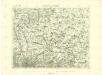
III. vojenské mapování 3859
1 : 75000
III. vojenské mapování 3858
1 : 75000
III. vojenské mapování 3859
1 : 75000
III. vojenské mapování 3858
1 : 75000
Podrobná mapa Markrabství moravského a Vévodství slezkého
1 : 100000 Javorník (Jeseník, Česko : oblast) Srp, Jan Jos. R. Vilímek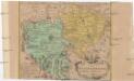
Das Fürstenthum Münsterberg in Nieder-Schlesien
1 : 170000 Dolní Slezsko Schleuen, Johann David I.D. Schleuen
Kunštát a Glatz
1 : 75000 Kladsko (Polsko : oblast) Vojenský zeměpisný ústav
Kronstadt a.d. Wilden Adler.; Spezialkarte der osterreichisch-ungarischen Monarchie.
from Spezialkarte der osterreichisch-ungarischen Monarchie. Austro-Hungarian Monarchy. Militärgeographisches Institut.,
Hotzenplotz und Zuckmantel
1 : 75000 Morava (Česko) Radler K. u. k. Militärgeographisches Institut
III. vojenské mapování 3857
1 : 75000