Maps of powiat żagański

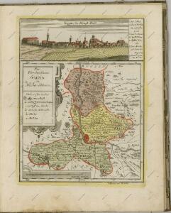
Principatus Silesiae Saganensis in suos Circulos Sagan, Priebus, et Naumburg divisi et.
1 : 108000 Mollova mapová sbírka Wieland, Johann Wolfgang Homann, Johann Baptista - dědici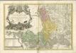
Principatus Silesiae Saganensis in suos circulos, Sagan, Priebus, et Naumburg divisi
1 : 110000 Zaháňsko (Polsko) Wieland, Johann Wolfgang Schubarth, Matthäus Haeredibus Homannianis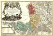
Principatus Silesiae Saganensis in suos Circulos Sagan, Priebus, et Naumburg divisi et
1 : 108000 Mollova mapová sbírka Wieland, Johann Wolfgang Homann, Johann Baptista - dědici
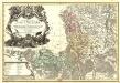
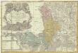
Das Fürstenthum Sagan in Nieder-Schlesien
1 : 260000 Mollova mapová sbírka Schleuen, Johann David Schleuen, Johann David
104. Guben, uit: Topographische Uebersichtskarte des Deutschen Reiches / herausgegeben v. d. Kartogr. Abt. d. Königl. Preuß. Landesaufnahme
1 : 200000 titelvariant: Topogr. Übersichtskarte des Deutschen Reiches; Annotatie: Titel boven bladen ook: Topogr. Übersichtskarte des Deutschen Reiches; Annotatie geografische gegevens: Op elk blad twee maatstokken: 10 Kilometer = 5,5 cm; 1 geogr. Meile = 3,6 cm; Legenda onder op elk blad Königlich Preußische Landesaufnahme. Kartographische Abtheilung [S.l : Königlich Preußische Landesaufnahme, Kartographische Abtheilung]
Das Fürstenthum Sagan in Nieder-Schlesien
1 : 280000 Zaháňsko (Polsko) Schleuen, Johann David Schleuen
Meßtischblatt 2627 : Ober- Leschen, 1921
1 : 250000 Ober- Leschen. - Hrsg. 1888, bericht. 1921. - 1:25000. - [Berlin]: Reichsamt für Landesaufnahme, 1921. - 1 Kt.
Meßtischblatt 2627 : Ober- Leschen, 1888
1 : 250000 Ober- Leschen. - Aufn. 1887. - 1:25000. - [Berlin]: Reichsamt für Landesaufnahme, 1888. - 1 Kt.
Meßtischblatt 4558 : Neuhammer am Queis, 1941
1 : 250000 Neuhammer am Queis. - Aufn. 1887/1922, hrsg. 1888, bericht. 1937, einz. Nachtr. 1938/39, Ausg. 1942 - 1:25000. - [Berlin]: Reichsamt für Landesaufnahme, 1941. - 1 Kt.
Meßtischblatt 2626 : Neuhammer am Queis, 1922
1 : 250000 Neuhammer am Queis. - Aufn. 1887, bericht. 1920, einz. Nachtr. 1922. - 1:25000. - [Berlin]: Reichsamt für Landesaufnahme, 1922. - 1 Kt.
Meßtischblatt 2626 : Loos, 1888
1 : 250000 Loos. - Aufn. 1887. - 1:25000. - [Berlin]: Reichsamt für Landesaufnahme, 1888. - 1 Kt.
Meßtischblatt 4557 : Rauscha, 1940
1 : 250000 Rauscha. - Aufn. 1887, hrsg. 1889, bericht. 1937, letzte Nachtr. 1938. - 1:25000. - [Berlin]: Reichsamt für Landesaufnahme, 1940. - 1 Kt.
Meßtischblatt 2625 : Rauscha, 1936
1 : 250000 Rauscha. - Hrsg. 1889, einz. Nachtr. 1929, gedr. [19]36. - 1:25000. - [Berlin]: Reichsamt für Landesaufnahme, 1936. - 1 Kt.
Meßtischblatt 2625 : Rauscha, 1889
1 : 250000 Rauscha. - Aufnahme 1887. - 1:25000. - [Berlin]: Reichsamt für Landesaufnahme, 1889. - 1 Kt.
Meßtischblatt 2624 : Freiwaldau, 1929
1 : 250000 Freiwaldau. - Hrsg. 1889, einz. Nachtr. 1929. - 1:25000. - [Berlin]: Reichsamt für Landesaufnahme, 1929. - 1 Kt.
Meßtischblatt 2624 : Freiwaldau, 1889
1 : 250000 Freiwaldau. - Aufn. 1887. - 1:25000. - [Berlin]: Reichsamt für Landesaufnahme, 1889. - 1 Kt.
Meßtischblatt 4555 : Priebus (Schlesien), 1940
1 : 250000 Priebus (Schlesien). - Aufn. 1887, hrsg. 1889, bericht. 1938. - 1:25000. - [Berlin]: Reichsamt für Landesaufnahme, 1940. - 1 Kt.
Meßtischblatt 2623 : Priebus, 1911
1 : 250000 Priebus. - Aufnahme 1887, hrsg. 1889, einz. Nachtr. 1911. - 1:25000. - [Berlin]: Reichsamt für Landesaufnahme, 1911. - 1 Kt.
Meßtischblatt 2623 : Priebus,1889
1 : 250000 Priebus. - Aufnahme 1887. - 1:25000. - [Berlin]: Reichsamt für Landesaufnahme, 1889. - 1 Kt.
Meßtischblatt 2554 : Sprottau, 1933 Sprottau
1 : 250000 Sprottau. - Hrsg. 1900, bericht. 1933. - 1:25000. - [Berlin]: Reichsamt für Landesaufnahme, 1933. - 1 Kt.
Meßtischblatt 2554 : Sprottau, 1903 Sprottau
1 : 250000 Sprottau. - Aufn. 1899, hrsg. 1900, einz. Nachtr. 1903. - 1:25000. - [Berlin]: Reichsamt für Landesaufnahme, 1903. - 1 Kt.
Meßtischblatt 2554 : Sprottau, 1900
1 : 250000 Sprottau. - Aufn. 1899, hrsg. 1900. - 1:25000. - [Berlin]: Reichsamt für Landesaufnahme, 1900. - 1 Kt.
Meßtischblatt 4458 : Mallmitz, 1937
1 : 250000 Mallmitz. - Hrsg. 1901, bericht. 1933, gedr. [19]37. - 1:25000. - [Berlin]: Reichsamt für Landesaufnahme, 1937. - 1 Kt.
Meßtischblatt 2553 : Mallmitz, 1901
1 : 250000 Mallmitz. - Aufn. 1899. - 1:25000. - [Berlin]: Reichsamt für Landesaufnahme, 1901. - 1 Kt.
Meßtischblatt 2552 : Halbau, 1905
1 : 250000 Halbau. - Aufn. 1899, hrsg. 1901. - 1:25000. - [Berlin]: Reichsamt für Landesaufnahme, 1905. - 1 Kt.
Meßtischblatt 2551 : Ndr. Hartmannsdorf, 1901
1 : 250000 Ndr. Hartmannsdorf. - Aufnahme 1899. - 1:25000. - [Berlin]: Reichsamt für Landesaufnahme, 1901. - 1 Kt.
Meßtischblatt 2550 : Zibelle, 1901
1 : 250000 Zibelle. - Aufn. 1899. - 1:25000. - [Berlin]: Reichsamt für Landesaufnahme, 1901. - 1 Kt.