Maps of Baden-Württemberg


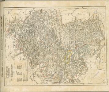
Hydrographische Durchlässigkeitskarte des Königreichs Württemberg
1 : 600000 Regelmann, Carl Giesecke & Devrient
Karte vom Königreich Wirtemberg nebst dem Fürstenthum Hohenzollern-Sigmaringen und Sigmaringen
1 : 440000 Sigmaringen (Německo) Walch, Johann Joh. Walch
Karte vom Königreich Wirtemberg nebst dem Fürstenthum Hohenzollern-Sigmaringen
1 : 440000 Württembersko (Německo) Walch, Johann Joh. Walch
Wurtemberg, Baden.
1 : 450000 Weiland, C. F. (Carl Ferdinand), d. 1847
Straßen im Königreich Württemberg 1848
Württemberg Straßennetz Kunz, Andreas ; Treiling, Thomas
Das Kœnigreich Würtemberg nebst dem Grosherzogthum Baaden, den Fürstenthümern Hohenzollern und Layen
1 Karte : Kupferdruck ; 59 x 53 cm Pflummern in A. G. Schneider u: Weigels kön: priv: Kunst u: Landkartenhandlung
Ducatus Wurtenbergici cum locis limitaneis utpote maxima parte circuli Suevici praesertim utroq. marchionatu Badensi et sylva vulgo Nigra
1 : 250000 Bádensko (Německo) Mejer, Johannes Homann, Johann Baptist J. B. Homann
Ducatus Wurtenbergici cum locis limitaneis utpote maxima parte circuli Suevici praesertim utroq. marchionatu Badensi et Sylva vulgo Nigra nova et post omnes exactissima deline[atio]
1 : 250000 Bádensko (Německo) Mejer, Johannes Homann, Johann Baptist Johann Baptist Homann
[Charte vom Königreich Würtemberg, und dem Grossherzogthum Baden]
Neuester Schul-Atlas Walch, Johann im Verlag bei Joh. Walch
Länder in Südwestdeutschland 1947
Land Baden, Württemberg-Hohenzollern Kunz, Andreas ; Treiling, Thomas ; Moeschl, Joachim
Geographica provinciarum Sveviae descriptio
Švábsko (Německo) Hurter, Johann Christoph Bodenehr, Gabriel Hanß Georg Bodenehr
[Geographica provinciarum Sveviae descriptio]
Švábsko (Německo) Hurter, Johann Christoph Bodenehr, Johann Georg bey Hanß Georg Bodenehr
Wirtenbergensis Ducatus Vera Descriptio, Tubingae Edita. 1558. [Karte], in: Theatrum orbis terrarum, S. 75.
1 Karte aus Atlas Ortelius, Abraham
Ducatus Wurtenbergensis
1 Karte : Kupferdruck ; 54 x 46 cm Visscher; Schenk; Gouwen nunc apud Pet: Schenk iun
Cours du Danube feuille I contenant la Suabe ou est exactement marquée la succession de Charles VI
1 Karte : Kupferdruck ; 47 x 55 cm Le Rouge chez le Rouge rue des Augustins vis a vis le Panier Fleuri
S.R.I. circulus Sueviae continens ducatum Wirtenbergensem alisq. status et provincias eidem circulo insertas
1 : 640000 Württembersko (Německo) Homann, Johann Baptist á Ioh. Bapt. Homanno
Wurtemberg.
1 : 555000 Flemming, Carl
Les Cours de Postes par le Cercle de Suabe, come ils se presentent dans la Carte Geographique
1 : 130000 Mollova mapová sbírka Homann, Johann Baptist Homann, Johann Baptista - dědici

Special Post Karte durch den schwaebischen Kreis
1 Karte : Kupferdruck ; 43 x 53 cm Homännische Erben
Special Post Karte durch den schwaebischen Kreis
1 Karte : Kupferdruck ; 43 x 54 cm Homännische Erben
Special Post Karte durch den schwaebischen Kreis
1 Karte : Kupferdruck ; 43 x 54 cm Homännische Erben
Charte des Königreichs Würtemberg und des Grossherzogthums Baadens nebst den angränzenden Ländern
1 : 698000 Bádensko (Německo) Tranquillo Mollo
Der Schwaebische Kreis
1 : 490000 Bavorsko (Německo) Walch, Johann bey Joh. Walch
Ducatus Würtenbergensis
1 : 190000 Mollova mapová sbírka Walther, Johann Georg Walther, Johann Georg
Ducatus Würtenbergici
1 Karte : Kupferdruck ; 47 x 58 cm Majer; Schenk Pieter Schenk
Ducatus Wirtenbergensis
1 Karte : Kupferdruck ; 45 x 56 cm Danckerts s.n.
Das Herzogthum Würtemberg
1 Karte : Kupferdruck ; 23 x 30 cm Reilly F. J. J. von Reilly