Maps of Belarus


Geologičeskaja karta Evropejskoj Rossii
1 : 2500000 Westblatt Karpinskij, A.P. (Aleksandr Petrovič) Kartografičeskoe zavedenie A.Il'ina
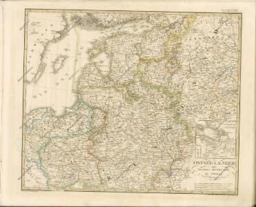
Ostsee-Laender und Inneres Russland bis Moskau
Hand-Atlas über alle Theile der Erde nach dem neuesten Zustande und über das Weltgebäude Stieler, Adolf bei Justus Perthes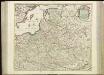
[71][71] Regni Poloniae et Ducatus Lithuaniae ..., uit: Atlas sive Descriptio terrarum orbis
Annotatie: Gedigitaliseerde versie. Amsterdam. Heiloo : Picturae (vervaardiger), 2015. tiff-bestand. Gedigitaliseerd: 07-01-2015; Origineel: Universiteitsbibliotheek Vrije Universiteit (XL.05127.-) ; Netherlands; Titelpagina ontbreekt Wit, Frederik de Amsterdam : Frederick de Wit
Ostsee-Laender und Inneres Russland bis Moskau
Hand-Atlas über alle Theile der Erde nach dem neuesten Zustande und über das Weltgebäude Stieler, Adolf bei Justus Perthes
Ostdeutschland - Westrußland - Nordösterreich
1 : 1500000 Evropa východní Mittelbachs Verlag
Übersicht des österrechisch-russischen Kriegsschauplatzes

Homannův atlas světa
1 : 400000
Ostsee-Laender und inneres Russland bis Moskau
1 : 3700000 Moskva-oblast (Rusko) Stülpnagel, Friedrich von Ausfeld, Johann Carl Justus Perthes
Ostsee-Laender und inneres Russland bis Moskau
1 : 3700000 Moskva-oblast (Rusko) Stülpnagel, Friedrich von Ausfeld, Johann Carl Justus Perthes

Russie occidentale, Pologne.
1 : 4060000 Picquet, C.
Regni Poloniae magnique ducatus Lithuaniae nova et exacta tabula / ad mentem Starovolcij descripta
1 : 3100000 1 Karte : Kupferdruck ; 48 x 56 cm Homann, Johann Baptist [Johann Baptist Homann]
Regni Poloniæ magnique ducatus Lithuaniæ nova et exacta tabula / ad mentem Starovolcij descripta
1 : 3100000 1 Karte : Kupferdruck ; 48 x 54 cm Starovolski, Simon [Johann Baptist Homann]
Regni Poloniae Magnique Ducat[us] Lithuaniae Nova et exacta Tabula
1 : 3000000 Homann, Johann Baptist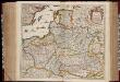
Regni Poloniae et ducatus Lithvaniae Voliniae, Podoliae Vcraniae Prvssiae, Livoniae et Cvrlandiae / descriptio emendata per F. de Wit Amstelodami
1 : 3000000 Annotatie: Rechtsboven: 14; Origineel is Blad 132 in atlas factice; Annotatie geografische gegevens: Met schaalstok: 15 Duytsche Mylen Frederick de Wit 1630-1706 [Amsterdam : F. de Wit]
Polen und Litthauen 1125-1386.
1 : 5000000 Spruner von Merz, Karl
Neberts Kriegs - Frontenkarte von allen Kriegsschauplätzen No 2

Polen und Litthauen nach der Lubliner Union 1569 und dem Aussterben der Jagiellonen 1572
1 : 12000000 Polen-Litauen
Friedensdislokation im europäischen Russland
1 : 2800000 Evropa východní
Polen und Litthauen unter den Jagjellonen 1386-1572.
1 : 5000000 Spruner von Merz, Karl
Russia Occidentale, Pologne Ancien.
1 : 4200000 Levasseur, E.
Regni Poloniae Magniquae Ducatus Lithuaniae Nova et exacta tabula
1 : 3000000 Litva Homann, Johann Baptist Starowolski, Szymon a Ioh. Bapt. Homanno
Russie occidentale, Pologne.
1 : 4060000 Brue, Adrien Hubert, 1786-1832
Regni Poloniae Magnique Ducatus Lithuaniae Nova et exacta Tabula ad mentem Starovolcii descripta à Ioh. Bapt. Homanno Sac. Caes. Mai. Geographo
Polen, Litauen Homann, Johann Baptist
Regni Poloniae et Ducatus Lithuaniae Voliniae, Podoliae Ucraniae Prussiae, Livoniae et Curlandiae descriptio [Karte], in: Novus atlas absolutissimus, Bd. 1, S. 93.
1 Karte aus Atlas Janssonius Offizin
Reipublicae et status generalis Poloniae nova tabula, comprehendens Majoris et Minoris Poloniae Regni, Magni Ducatus Lithuaniae, Ducatus Prussiae, Curlandiae, Russiae Ucraniae, Massoviae, Volhyniae et Podoliae, accuratam descriptionem
Polen, Großfürstentum Litauen de Wit, Frederik, http://d-nb.info/gnd/11931648X
Volker und Reiche der Slaven zwischen Elbe und Don bis 1125.
1 : 5000000 Spruner von Merz, Karl