Maps of Metropolitan France

Skizzen zu den größeren Manövern der fremden Armeen 1906
Francie Streffleur, Valentin Ritter von L. W. Seidel & Sohn
[Historisch-geographischer Atlas zu den allgemeinen Geschichtswerken von C. v. Rotteck, Pölitz u. Becker] : Gallien, Britannien, Germanien und die obern Donau-Länder nach Cæsar, Tacitus, Ptolemæus, Plinius, etc.
von Joh. Val. Kutscheit Lithographie der Herderschen Verlags-Handlung zu Freiburg im Breisg. [Freiburg im Breisgau] : [Herder]
Itineraire-Karte
1 : 6000000 Evropa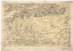
[Centralis Europae]
Evropa střední Schedel, Hartmann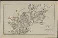
Schul-Atlas für die alte Erdbeschreibung : zur allgemeinen Schul-encyclopädie gehörig
J. H. Campe Zusammensetzung und Zeichnung von [...] Dufour, unter Leitung von Heusinger ; gestochen von Frentzel. Braunschweig : Schulbuchhandlung
Porostní mapa revíru Srbice
1 : 2880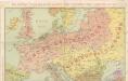
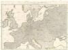
Die Karte von Europa...
Wege-Karte durch den grösten und wichtigsten Theil Europa's
Evropa Schmidt, Johann Marius Friedrich Kliewer, Heinrich Simon Schropp et Comp.
Germany.
from A new sett of maps both of antient and present geography : wherein not only the latitude and longitude of many places are corrected according to the latest observations, but also the most remarkable differences of antient and present geography may be quickly discern'd by a bare inspection or comparing of correspondent maps, which seems to be the most natural and easy method to lead young students (for whose use the work is principally intended) unto a competent knowledge of the geographical science : together with a geographical treatise particularly adapted to the use and design of these maps / by Edward Wells, M.A. and student of Christ-Church, Oxon.
Kriegszusammenhänge IV (1740 - 1763)
1 : 15000000 Europa Österreichischer Erbfolgekrieg , Schlesische Kriege
Germania.
from Abraham Ortelius his epitome of the theater of the worlde / nowe latlye ... renewed and augmented ... by Micheal Coignet, mathematitian of Antwarpe.
Carte itinéraire de l'Europe indiquant les limites actuelles des etats
1 : 3760000 Evropa Dufour, A. H. Simonneau, Charles Ch.les Simonneau
Germany.
from A system of geography, or, A new & accurate description of the earth in all its empires, kingdoms and states : illustrated with history and topography, and maps of every country : fairly engraven on copper, according to the latest discoveries and corrections / by Herman Moll.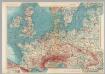
Western Europe. Pergamon World Atlas.
1 : 5000000 Polish Army Topography Service
30. Mitteleuropa nach Beendigung des nordischen Krieges im Jahre 1721
Mitteleuropa, Ostmitteleuropa, Nordischer Krieg <1700-1721>
29. Mitteleuropa im Jahre 1650
Mitteleuropa
Carte Generale des Chemin de Fer Europeens.
1 : 3200000 Migeon, J.
Conspectus Generalis omnium earum partium quae unquam ad Imperium Francicum vel Franco-Romanum demum Romano-Germanicum diversis temporum periodis pertinuerunt.
1 : 11000000 Mollova mapová sbírka Homann, Johann Baptist Homann, Johann Baptista - dědici
Gran carta del teatro della guerra nel 1870
1 : 2340000 Evropa střední Stabilimento civelli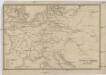
Übersichtskarte des Eisenbahn- und Telegraphen-Verbindungen von Mittel-Europa
1 : 6170000 Evropa střední Mayer, Alexander
Říše Karla Velikého

Kriegszusammenhänge I (1618 - 1660)
1 : 12000000 Ostmitteleuropa Dreißigjähriger Krieg, Nordischer Krieg <1655-1660>
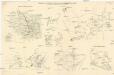
Rozšíření nejstarší keramiky české v Evropě
Evropa
France, Switzerland, Germany.
Goodrich, S.G.
Carte de la marche des Burgondes
Europa Burgunden Völkerwanderungszeit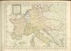

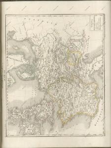
Gallia, Britannia, Germania, Provinciae danuvienses.
1 : 5000000 Kiepert, Heinrich, 1818-1899
[Nord- und Istsee]
Atlas der Hydrographie Berghaus, Hermann Justus Perthes