Maps of Aveyron

Maps of Aveyron

$title$

$title$

Dept. De L'Aveyron.

1 : 585000 Levasseur, Victor.
$title$

$title$

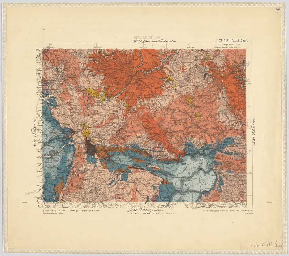
34) XI.N.E. ''Aurillac'', uit: Carte géologique de France

1 : 500000 Annotatie: Voor aanwezige bladen zie bladoverzicht [S.l : s.n.]
$title$

Département du Tarn

1 Karte : Kupferdruck ; 49 x 48 cm Houdan; Dumez chez Dumez directeur de l'Atlas national rue de la Harpe no. 26, et au dépôt de cet atlas placé au cabinet bibliographique rue de la Monnoye no. 5
$title$

Archevesché d'Alby

1 Karte : Kupferdruck ; 33 x 44 cm Sanson; Robert de Vaugondy ches le Sr. Robert g. du r. quai de lHorloge du Palais
$title$

$title$

Dept. Du Tarn.

1 : 563000 Levasseur, Victor.
$title$

$title$

Carte dv diocese d'Alby

1 Karte : Kupferdruck ; 26 x 36 cm Merian Caspar Merian
$title$

16 Rodez.

1 : 86400 Cassini family; Cassini, Cesar-Francois, 1714-1784
$title$

[Rodez]

1 Blatt : 56 x 89 cm s.n.
$title$

[Albi]

1 Blatt : 56 x 89 cm s.n.
$title$

EPISCOPATVS | ALBIENSIS, | EVESCHÉ D'ALBY

Amstelædami exc. Joannes Blaeu
$title$

Carte du diocese d'Alby

1 : 110000
$title$

17 Albi.

1 : 86400 Cassini family; Cassini, Cesar-Francois, 1714-1784
$title$

[Nant - Millaud]

1 Blatt : 56 x 89 cm s.n.
$title$

[Mende]

1 Blatt : 56 x 89 cm s.n.
$title$

15 Aurillac.

1 : 86400 Cassini family; Cassini, Cesar-Francois, 1714-1784
$title$

55 Mende.

1 : 86400 Cassini family; Cassini, Cesar-Francois, 1714-1784
$title$

[Aurillac]

1 Blatt : 56 x 89 cm s.n.
$title$

37 Montauban.

1 : 86400 Cassini family; Cassini, Cesar-Francois, 1714-1784
$title$

36 Cahors.

1 : 86400 Cassini family; Cassini, Cesar-Francois, 1714-1784
$title$

Govverneme[n]t de Milhau

1 Karte : Kupferdruck ; 11 x 15 cm Sebastian Cramoisy
$title$

Roqvecovrbe

1 Plan : Kupferdruck ; 11 x 15 cm Sebastian Cramoisy
$title$

Carte topographique du Canton de St. Antonin, Arrond.t de Montauban, Département de Tarn-et-Garonne / par Aubry

1 : 30000 Aubry, ... [S.l. : s.n.]
$title$

35 Sarlat.

1 : 86400 Cassini family; Cassini, Cesar-Francois, 1714-1784
$title$

Partie orientale du gouvernement général de la Guienne

1 Karte : Kupferdruck ; 47 x 50 cm Robert de Vaugondy G. et D. Robert de Vaugondy
$title$

La partie meridionale du Languedoc

1 Karte : Kupferdruck ; 35 x 46 cm Schenk; Valck; Tavernier apud Petrum Schenk et G. Valk
$title$

La partie meridionale du Languedoc

1 Karte : Kupferdruck ; 36 x 47 cm Hondius; Tavernier imprimé chez Henrÿ Hondius, chez Melchior Tavernier demeurant aupres du palais
© MapTiler © OpenStreetMap contributors
How does it work?
These instructions will show you how to find historical maps online.
Getting started
Type the place name in the search box to find the exact location. You can further adjust the search by zooming in and out.
Zoom
Zoom in and out with the buttons or use your mouse or touchpad natively.
Exact Area tool
Click here and draw a rectangle over the map to precisely define the search area.
Set filters
Narrow your search with advanced settings, such as Years (from/to), Fulltext, Publisher, etc.
Results
See the results of your search on the right side. You can scroll down to find more maps of this location.
?

Download OldMapsOnline Mobile