Maps of Chieti
No. 4. Pescara, Ortona, Chieti, Laciano
1 : 114000 Rizzi Zannoni, Giovanni Antonio (1736-1814)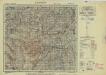
Italy 1:100,000, Lanciano
A map within the 303-sheet series, Italy 1:100,000 / Sardinia 1:100,000 , Series GSGS 4164. The graticuleis based on the Rome (Monte Mario) meridian.?? Great Britain. War Office. General Staff. Geographical Section. [London] : War Office
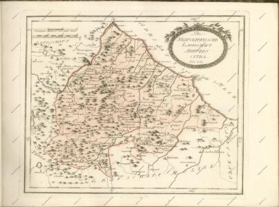
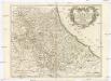
ABRVZZO | CITRA | ET | VLTRA
[Amsterdam : Joan Blaeu]
Abruzzo Citra, Et Ultra. [Karte], in: Theatrum orbis terrarum, sive, Atlas novus, Bd. 3, S. 225.
1 Karte aus Atlas Blaeu, Joan Blaeu, Willem Janszoon
Abruzzo Citra, Et Ultra. [Karte], in: Le théâtre du monde, ou, Nouvel atlas contenant les chartes et descriptions de tous les païs de la terre, Bd. 3, S. 237.
1 Karte aus Atlas Blaeu, Willem Janszoon und Blaeu, Joan Blaeu, Willem Janszoon
Abruzzo Citra, Et Ultra. [Karte], in: Novus Atlas, das ist, Weltbeschreibung, Bd. 3, S. 261.
1 Karte aus Atlas Blaeu, Joan Blaeu, Willem Janszoon
Generalkarte von Zentraleuropa

Abruzzo Citra, Et Ultra. [Karte], in: Novus atlas absolutissimus, Bd. 5, S. 212.
1 Karte aus Atlas Janssonius Offizin
L'Abrvzzo Citra et vltra
1 : 315000 Abruzzo (Itálie) De Rossi, Domenico Domenico de Rossi
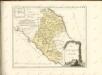
Abruzzo Ulteriore e Citeriore tratta dalle carte del Sig. Rizzi Zannoni.
No. 6. Campobasso, Trivento, Agnone
1 : 114000 Rizzi Zannoni, Giovanni Antonio (1736-1814)
L'Abrvzzo citra et vltra
1 : 326000 Abruzzo (Itálie) Magini, Giovanni Antonio Domenico de Rossi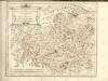

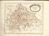
Abrvzzo et Terra di Lavoro
1 Karte : Kupferdruck ; 33 x 47 cm Mercator; Hondius Henricus Hondius
Abrvzzo et Terra di Lavoro
1 Karte : Kupferdruck ; 33 x 47 cm Mercator s.n.

Übersichtskarte von Mittel - Europa

Rom, Ancona, Pescara, Velletri
1 : 750000 Ancona (Itálie) Lorenz, K. K. u. k. Militärgeographisches Institut
Rom, Ancona, Pescara, Velletri
1 : 750000 Ancona (Itálie) K. k. militär-geographisches Institut
XVII, uit: General-Karte des oesterreichischen Kaiserstaates mit einem grossen Theile der angrenzenden Länder / durch Josef Scheda ... bearb. und hrsg
1 : 576000 Annotatie geografische gegevens: Maatstokken: oesterreichische Meilen, geografische oder deutsche Meilen, preussische Meilen, türkische Berri, französische Lieues, russische Werste; Maatstok per blad: wiener Klafter, öster. Meilen; Blad XIX: statistische en taalkundige informatie; Blad XIX: legenda [Wien : K.K. Militärisch-Geografisches Institut]
Abruzzo Et Terra Di Lavoro. [Karte], in: Gerardi Mercatoris Atlas, sive, Cosmographicae meditationes de fabrica mundi et fabricati figura, S. 462.
1 Karte aus Atlas Mercator, Gerhard Montanus, Petrus
Post und Eisenbahnkarte der Österreichisch-Ungarischen Monarchie

Central Italy. Italia Media
1 : 1100000 Arrowsmith, Aaron Jr.

Střední stará Italia
1 : 1720000 Itálie Fáborský, Jan B. nákladem Dědictví sv. Cyrilla a Methodia
Strassen- und Eisenbahnkarte des oesterreichischen Kaiserthumes
1 : 864000 Blatt 14 Schaller, G. K.K. Militärisch-Geografisches Institut, Karten-Evidenthaltungs-Abteilung