Maps of Libyan Desert


Les Deserts D'Egypte, De Thebaide D'Arabie. De Sirie. &c: ou Sont exactement Marques Les Lieuz Habitez Par Les Saincts Peres Des Deserts [Karte], in: Atlas nouveau, contenant toutes les parties du monde [...], Bd. 2, S. 220.
1 Karte aus Atlas Sanson, Nicolas Jaillot, Alexis Hubert und Mortier, Pieter
Turkey, Arabia, Persia, Hindoostan, China.
Goodrich, S.G.
Vorderer Orient

[Afrika, Blatt 2]
Adolf Stieler's Handatlas über alle Theile der Erde und über das Weltgebäude Stieler, Adolf Justus Perthes
A new map shewing the travels of the patriarchs, as also of the children of Israel, from Egypt through the wilderness to the land of Canaan.
from A new sett of maps both of antient and present geography : wherein not only the latitude and longitude of many places are corrected according to the latest observations, but also the most remarkable differences of antient and present geography may be quickly discern'd by a bare inspection or comparing of correspondent maps, which seems to be the most natural and easy method to lead young students (for whose use the work is principally intended) unto a competent knowledge of the geographical science : together with a geographical treatise particularly adapted to the use and design of these maps / by Edward Wells, M.A. and student of Christ-Church, Oxon.
[Recto], uit: Midden-Oosten (Nabije-Oosten) / [aardrijksk. medew. G.J. de Vries]
1 : 13700000 Annotatie: Verso: namen van de landen van het Midden-oosten met aanduiding van de oppervlakte en het aantal inwoners,de hoofdsteden met vermelding van het het aantal inwoners, en informatie over het Suezkanaal; Annotatie geografische gegevens: Inzet: Suez Kanaal Gerben Johannes de Vries 1886-1968 Sneek : Tonnema
Říše turecká
1 : 5000000 Asie jihozápadní V. Neubert
Tableau l'historie de l'Empire des Califes et de l'Empire de Turquie.
1 : 20000000 Duval, Henri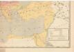
Evropa raného středověku: do konce VI. století po Kr.
Kašpar, Jan
[Das Mittelländische Meer und Nord-Afrika, Östliches Blatt]
Hand-Atlas über alle Theile der Erde und über das Weltgebäude Stieler, Adolf Justus Perthes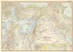
Lands of the bible today

Orbis Romani Pars Orientalis.
1 : 10137600 Lucas, Fielding Jr.
Orbis Romani, pars orientalis.
1 : 4300000 Anville, Jean Baptiste Bourguignon d, 1697-1782
[Das Mittelländische Meer und Nord-Afrika]
Handatlas über alle Theile der Erde und über das Weltgebäude Stieler, Adolf Justus Perthes
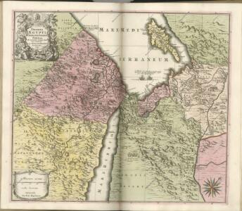
Egypte, Nubie et Abissinie
1 : 9600000 Egypt Bonne, Rigobert
Tabula Asiae IIII. [Karte], in: Claud. Ptolemaeus. Geographia lat. cum mappis [...], S. 305.
1 Karte aus Atlas Münster, Sebastian [und Ptolemaeus, Claudius]
Spezial - karte von AfricaSektion Ägypten (3)
1 : 4000000 1 full d'1 mapa en 10 fulls i estoig Hermann Habenicht; Justus Perthes
[Des Mittelländischen Meeres öestliches Blatt. Zur Uebersicht des Türkischen Reichs und als Pecial-Karte der Asiatischen u. Afrikanischen Türkey]
Stieler's Hand-Atlas Stieler, Adolf bei Justus Perthes
[Kaart], uit: [Kaart van de Nijl-delta]
1 : 300000 Annotatie: Tekst in het Arabisch [S.l. : Top. Dienst]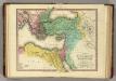
Patriarchati Orientales. (1826)
1 : 19000000 Tanner, Henry S.
Die Nilländer und Westarabien
1 : 5000000 Arabský poloostrov Kiepert, Richard Dietrich Reimer
Orbis Romani, orientalis.
1 : 11500000 Anville, Jean Baptiste Bourguignon d, 1697-1782; M'Dermut, Robert
Imperium Turcicum
Turecko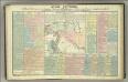
Tableau historique des Empires d'Assyrie, de Babylone.
1 : 23500000 Duval, Henri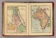
Egypt, Africa.
Goodrich, S.G.
Nillander.
1 : 5000000 Weiland, C. F. (Carl Ferdinand), d. 1847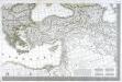
Carte d'Europe ou sont tracées les limites des empires, royaumes, et etats souverains, feuille 6
1 Blatt : 63 x 93 cm Semen etc
Das Osmanische Reich nebst seinen Schutzstaaten nach seiner grössten Ausdehnung 1682
Osmanisches Reich