Maps of Nièvre

Ambivareti in Æduis ubi postea Vadicasses
1 Karte : Kupferdruck ; 41 x 50 cm Sanson; Robert de Vaugondy ches le S. Robert g. du r. quai de l'Horloge du Palais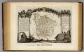
Dept. De La Nievre.
1 : 599000 Levasseur, Victor.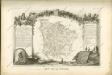

Département de la Nyevre
1 Karte : Kupferdruck ; 49 x 48 cm Houdan au bureau de l'atlas national rue Serpente n.o 15
Département de la Nyevre
1 Karte : Kupferdruck ; 34 x 40 cm Capitaine s.n.
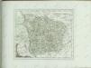
NIVERNIVM | DVCATVS, | Gallicè | DVCHE DE NEVERS
Amsterdami, | Apud Guiljelmum et Iohannem Blaeuw
Carte dv païs et Duchè de Nivernois
1 Karte : Kupferdruck ; 36 x 48 cm Janssonius sumptibus Ioannis Ianssonii
Carte dv païs et Duchè de Nivernois
1 Karte : Kupferdruck ; 35 x 47 cm Schenk; Valck apud G. Valk et P. Schenk
Nivernivm dvcatvs
1 Karte : Kupferdruck ; 36 x 48 cm Blaeu; Blaeu apud Guiljelmum et Iohannem Blaeuw
Carte dv païs et Duchè de Nivernois
1 Karte : Kupferdruck ; 36 x 48 cm Mercator; Hondius sumptibus Henrici Hondij
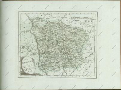
Département de la Nyevre
1 : 260000 Nevers (Francie) Houdan, François d' P. G. Chanlaire
Carte Du Païs et Duchè de Nivernois [Karte], in: Novus atlas absolutissimus, Bd. 4, S. 200.
1 Karte aus Atlas Janssonius Offizin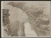
Carte Du Païs et Duchè de Nivernois [Karte], in: Gerardi Mercatoris et I. Hondii Newer Atlas, oder, Grosses Weltbuch, Bd. 2, S. 89.
1 Karte aus Atlas Mercator, Gerhard und Hondius, Jodocus Jansson, Jan
Nivernium Ducatus, Gallicè Duche De Nevers. [Karte], in: Novus Atlas, das ist, Weltbeschreibung, Bd. 2, S. 100.
1 Karte aus Atlas Blaeu, Joan Blaeu, Willem Janszoon
Nivernium Ducatus, Gallicè Duche De Nevers. [Karte], in: Theatrum orbis terrarum, sive, Atlas novus, Bd. 2, S. 99.
1 Karte aus Atlas Blaeu, Joan Blaeu, Willem Janszoon
Nivernium Ducatus, Gallicè Duche De Nevers. [Karte], in: Le théâtre du monde, ou, Nouvel atlas contenant les chartes et descriptions de tous les païs de la terre, Bd. 2, S. 98.
1 Karte aus Atlas Blaeu, Willem Janszoon und Blaeu, Joan Blaeu, Willem Janszoon
Duché et gouvernement general de Nivernois
1 Karte : Kupferdruck ; 47 x 60 cm Delafosse; Daumont; Durand; Haussard chés Daumont rue St. Martin pres St. Julien
Duche et gouvernment general de Nivernois
1 : 240000 Nevers (Francie) Delafosse, D. Durand

Carte du païs et duchè de Nivernois
1 : 120400
Ambivareti in Aeduis, ubi postea Vadicasses, Evesché de Nevers
1 : 210000
Gouvernement de Nivernois
1 Karte : Kupferdruck ; 30 x 41 cm Mentelle; Tardieu; Dubuisson Mentelle
[Nevers]
1 Blatt : 60 x 91 cm s.n.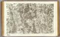
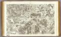
49 Nevers.
1 : 86400 Cassini family; Cassini, Cesar-Francois, 1714-1784
Gowerneme[n]t de Moulins e[n] Gilbert
1 Karte : Kupferdruck ; 11 x 15 cm Sebastian Cramoisy
Govvernement de Neuers
1 Karte : Kupferdruck ; 11 x 15 cm Sebastian Cramoisy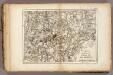
Morvan.
1 : 186000 Vincent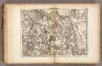
Morvan.
1 : 186000 Vincent