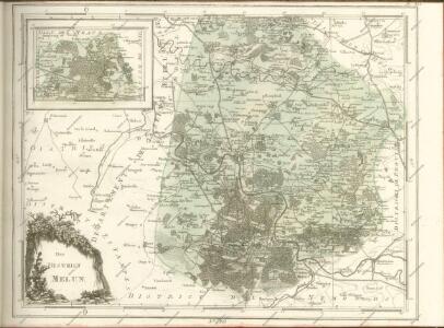
Maps of Melun

Carte de la foret de Fontainebleau
1 : 100000 Fontainebleau-oblast (Francie) Collon, J. S. Petit
Carte des chasses du Roi à Fontainebleau / levée par les officiers du Corps Royal des Ingénieurs-Géographes et dressée au Dépot Général de la Guerre ; gravée par J. Orgiazzi
1 : 35000 Annotatie: Herdruk van originele koperplaat; Oorspr. uitg.: [Paris] : Dépôt Général de la Guerre, 1809 Orgiazzi, J.; Corps Royal des Ingénieurs-Géographes, Frankrijk; Dépôt de la Guerre, Frankrijk [Paris : IGN]
Carte des chasses du roi, a Fontainebleau
1 : 34560 Fontainebleau-oblast (Francie) Orgiazzi, J.
95 [bijkaart] Forêt de Fontainebleau, uit: Environs de Paris : carte des curiosités et des routes pittoresques
1 : 100000 Paris : Services du Tourisme Michelin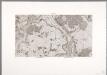
Flle. 12. Corbeil, uit: Carte topographique des environs de Versailles dite "Carte des chasses du Roi"
1 : 28800 titelvariant: Carte des chasses du Roi; Annotatie: Herdruk van originele koperplaten; Oorspr. uitg.: 1764-1807; Voor aanwezige bladen zie overzichtsblad; Annotatie geografische gegevens: Opname: 1764-1773 [Paris : IGN]
Gowernemet de Corbeil
1 Karte : Kupferdruck ; 11 x 15 cm Sebastian Cramoisy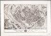
Tableau topographique de la Fôret de Sénart / ... G. Coutans
1 : 14400 Annotatie: Herdruk van originele koperplaat; Oorspr. uitg.: 1786 Coutans, G. [Paris : IGN]
Gowernement d'Estampes
1 Karte : Kupferdruck ; 11 x 15 cm Sebastian Cramoisy
Paris 123, uit: [W. Liebenow's Special-Karte von Mittel-Europa]
1 : 300000 titelvariant: W. Liebenow's Mittel-Europa; Annotatie: Titel boven de bladen: W. Liebenow's Mittel-Europa Johannes Wilhelm Liebenow 1822-1897 Hannover : Hermann Oppermann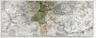
Les environs de Paris, 2
2 Blätter : 45 x 112 cm Nolin
Paris 123, uit: Special-Karte von Mittel-Europa / nach amtlichen Quellen bearbeitet von W. Liebenow
1 : 300000 titelvariant: W. Liebenow's Mittel-Europa; Annotatie: Titel boven de bladen: W. Liebenow's Mittel-Europa Johannes Wilhelm Liebenow 1822-1897 Frankfurt a. M. : Ludwig Ravenstein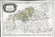
Senones
1 Karte : Kupferdruck ; 36 x 56 cm Sanson; Robert de Vaugondy chés le S. Robert geographe du roi quai de l'Horloge du Palais
Le comté de la Brie
1 Karte : Kupferdruck ; 35 x 47 cm Mercator; Hondius Henricus Hondius
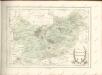
Le pais de Brie
1 Karte : Kupferdruck ; 37 x 48 cm Blaeu Guiljelmus Blaeu excudit
[Le pais de Brie]
1 Karte : Kupferdruck ; 38 x 48 cm Janssonius Joannes Janssonius excudit
Le pais de Brie
1 Karte : Kupferdruck ; 37 x 48 cm Valck; Schenk penes G. Valk et P. Schenk
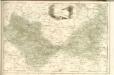
Environs de Paris
1 Karte : Kupferdruck ; 48 x 58 cm Robert de Vaugondy G. et D. Robert de Vaugondy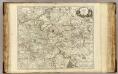
Environs de Paris.
1 : 182000 Robert de Vaugondy, Gilles, 1688-1766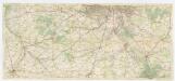
[Michelin 95], uit: Environs de Paris : carte des curiosités et des routes pittoresques
1 : 100000 Paris : Services du Tourisme Michelin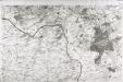
[Fontainebleau - Etampes]
1 Blatt : 60 x 91 cm s.n.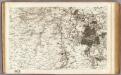
7 Fontainebleau, Etampes.
1 : 86400 Cassini family; Cassini, Cesar-Francois, 1714-1784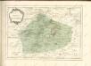
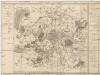
Département de la Seine
1 : 70500 Paříž-oblast (Francie) Chanlaire, P. G. P.G. Chanlaire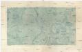
Sceaux
1 : 29236 Francie Doudau
Govvernement de St. Mathurin de l'Arquan
1 Karte : Kupferdruck ; 11 x 15 cm Sebastian Cramoisy
Sud-Est: Paris Et Ses Environs.
1 : 40000 Service Geologique Des Mines (France)