Maps of Jouarre

Evesché de Meaux
1 Karte auf 2 Blättern : Kupferdruck ; 76 x 67 cm Chevalier; Jaillot; Cordier chez le Sr. Iaillot geographe du roy joignant les grands Augustins au 2 globes
France 1:100,000. Meaux
France 1:100 000, 21 A Gp No 23. [S.l.] : [21st Army Group, United Kingdom]
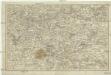
Le comté de la Brie
1 Karte : Kupferdruck ; 35 x 47 cm Mercator; Hondius Henricus Hondius
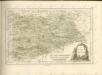
Le pais de Brie
1 Karte : Kupferdruck ; 37 x 48 cm Blaeu Guiljelmus Blaeu excudit
[Le pais de Brie]
1 Karte : Kupferdruck ; 38 x 48 cm Janssonius Joannes Janssonius excudit
Le pais de Brie
1 Karte : Kupferdruck ; 37 x 48 cm Valck; Schenk penes G. Valk et P. Schenk
[Meaux]
1 Blatt : 60 x 91 cm s.n.
45 Meaux.
1 : 86400 Cassini family; Cassini, Cesar-Francois, 1714-1784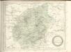

Karta dlja ob‘‘jasnenija sraženiji pri Šampoberě, Monmiralě i Vošaně s‘‘ 29. Janv. Po 3 fevr. 1814 g.
Frankreich Champaubert Montmirail (Marne) Befreiungskriege <1813-1815> Champaubert / Schlacht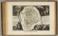
Dept. De Siene et Marne.
1 : 570000 Levasseur, Victor.
Département de Seine et Marne
1 Karte : Kupferdruck ; 49 x 48 cm Houdan au bureau de l'atlas national de France rue de la Monnoye no. 5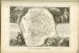

Le Theatre de Bellone :
Mollova mapová sbírka Schenk, Pieter Braakman, Adriaan
[Sud-est environs de Paris]
Paříž-oblast (Francie)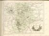

Le Pais De Brie. [Karte], in: Theatrum orbis terrarum, sive, Atlas novus, Bd. 2, S. 59.
1 Karte aus Atlas Blaeu, Joan Blaeu, Willem Janszoon
LE PAIS | DE | BRIE
Guiljelmus Blaeu | excudit
Le Pais De Brie. [Karte], in: Novus Atlas, das ist, Weltbeschreibung, Bd. 2, S. 48.
1 Karte aus Atlas Blaeu, Joan Blaeu, Willem Janszoon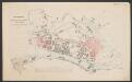
Le Pais De Brie. [Karte], in: Le théâtre du monde, ou, Nouvel atlas contenant les chartes et descriptions de tous les païs de la terre, Bd. 2, S. 48.
1 Karte aus Atlas Blaeu, Willem Janszoon und Blaeu, Joan Blaeu, Willem Janszoon
Le Pais De Brie. [Karte], in: Novus atlas absolutissimus, Bd. 4, S. 77.
1 Karte aus Atlas Janssonius Offizin
Sheet 6, uit: Stanford's large scale map of the seat of war / Stanford's Geographical Estab[lishmen]t
1 : 300000 Stanford's Geographical Establishment, Londen London : Stanford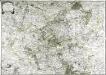
Carte des environs de Paris
1 Karte : Kupferdruck ; 57 x 81 cm Brion de la Tour; Viguet; Le Campion; Le Campion chez les Campion freres rue S. Jacques à la ville de Rouen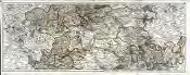
Carte du gouvernement de Champagne, 2
2 Blätter : 38 x 95 cm Bourgoin
Carte du gouvernement général de l'Isle de France, 2
1 Blatt : 79 x 55 cm Esnauts et Rapilly
Gouvernement de l'Isle de France
1 : 390000 Île-de-France (Francie) Johannes Janssonius?