Maps of Ciudad Real
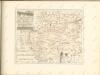

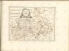
Provincia de la Mancha donde se comprehenden los partidos de Ciudad-Real, Infantes, y Alcaràz
1 Karte : Kupferdruck ; 36 x 37 cm López s.n.
Provincia de la Mancha donde se comprehenden los partidos de Ciudad-Real, Infantes, y Alcaràz
1 : 500000 compuesta sobre las mejores memorias impresas y manuscritas, y sujeta à las observaciones astronomicas por D. Thomàs Lopez, pensionista de S. M. Madrid : [Thomas Lopez]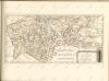
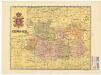
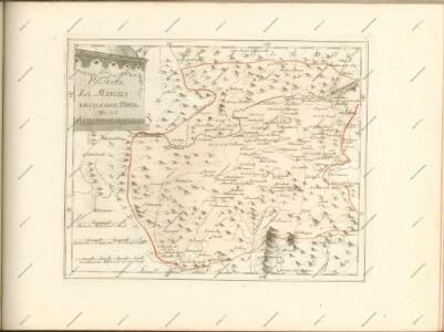
Ciudad-Real
Ed. Alberto Martín; F. Galceran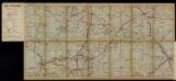
Guías-mapas de carreteras de España y Portugal. No 1 [Zona Ciudad Real, Córdoba, Jaén, Murcia]
Autopista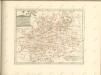

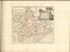
Castiliæ novæ pars occidentalis provincias Madrit, Toledo et Mancha comprehendens
1 Karte : Kupferdruck ; 48 x 46 cm Güssefeld; López apud Homannianos Heredes
Castiliæ novæ pars orientalis provincias Cuenca et Guadalaxara comprehendens
1 Karte : Kupferdruck ; 51 x 43 cm Güssefeld; López apud Homannianos Heredes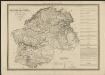
Cataluña con las nuevas divisiones
1 : 600000 formada por A. H. Dufour Paris : Bulla
Andalvzia continens Sevillam et Cordvbam
1 Karte : Kupferdruck ; 36 x 48 cm Janssonius Joannes Janssonius
Andalvzia continens Sevillam et Cordvbam
1 Karte : Kupferdruck ; 36 x 48 cm Blaeu Joan Blaeu
Andaluzia continens Sevillam et Cordubam. [Karte], in: Le théâtre du monde, ou, Nouvel atlas contenant les chartes et descriptions de tous les païs de la terre, Bd. 2, S. 233.
1 Karte aus Atlas Blaeu, Willem Janszoon und Blaeu, Joan Blaeu, Willem Janszoon
Andaluzia continens Sevillam et Cordubam. [Karte], in: Theatrum orbis terrarum, sive, Atlas novus, Bd. 2, S. 240.
1 Karte aus Atlas Blaeu, Joan Blaeu, Willem Janszoon
Andaluzia
1 Karte : Kupferdruck ; 17 x 24 cm Mercator; Keere Cloppenburgh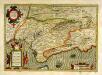
Andaluziæ nova descript
1 Karte : Kupferdruck ; 34 x 49 cm Mercator; Hondius; Hondius Henricus Hondius
Andaluziæ nova descript
1 Karte : Kupferdruck ; 34 x 49 cm Hondius; Mercator Jodocus Hondius
A map of old & new Castile
1 : 1100000 Kastilie (Španělsko) Mendes Silva, Rodrigo Ioh. Senex

Castilla la Nueva con las nuevas divisiones
1 Mapa. Atlas Nacional de España Dufour, A.H. 0
Andaluziae Nova Descript. [Karte], in: Gerardi Mercatoris et I. Hondii Newer Atlas, oder, Grosses Weltbuch, Bd. 2, S. 204.
1 Karte aus Atlas Mercator, Gerhard und Hondius, Jodocus Jansson, Jan
Andaluziae Nova Descript. [Karte], in: Gerardi Mercatoris Atlas, sive, Cosmographicae meditationes de fabrica mundi et fabricati figura, S. 186.
1 Karte aus Atlas Mercator, Gerhard Montanus, Petrus
Neueste Generalkarte von Portugal und Spanien, 5
1 Blatt : 70 x 50 cm Schrämbl
Regnorum Castellæ veteris Legionis et Gallæciæ principatuumque Biscaiæ et Asturiarum accuratissima descriptio, 5
1 Blatt : 54 x 41 cm Visscher
Spanien Und Portugal In 4 Blattern. Blatt 3.
1 : 1500000 Vogel, C.
Regna Hispaniarum, atque Portugalliæ, 3
1 Blatt : 53 x 63 cm Gerard Valck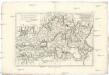
Castille Nouvelle, et r. de Valence
1 : 7660000 Kastilie (Španělsko) Bonne, Rigobert André