Maps of Slovakia
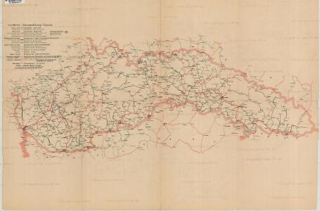
Mapa o stavu čs. silnic
Übersichtskarte von Böhmen, Mähren und Schlesien

[Russischer Vormarsch auf Budapest]
Ungarn Militärische Planung, Strategische Offensive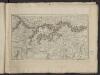
Théatre de la guerre actuelle, en Allemagne, en Pologne et en Turquie. n11, Hte. Hongrie, Vienne
1 : 900000 Chanlaire, Pierre Grégoire 1758-1817 Paris : chez l'auteur P. G. Chanlaire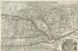
Neue Land Tafel von Hungarn
1 : 1100000 Mollova mapová sbírka Sandrart, Jakob von Sandrart, Jacob von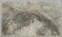
Composite III, IV, V, VIII, IX, X: Karte Des Oesterreichischen Kaiserstaates.
1 : 576000 Scheda, Josef
Galizien, Nord Ungarn und ein Theil von Siebenbürgen
1 : 1863880 Druck u. Verlag von C. Flemming
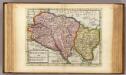
Neűe und richtige abbildung deß gantzen Königreichs Ungern sampt denen daran stossenden Ländern Bey der zugleich heraußgegebenen neuen und kurtzen beschreibung dieses Königreichs nützlich zu gebrauchen
1 : 1200000 Mollova mapová sbírka Pfann, Wilhelm Hofmann, Johann
Zuid Gouv.Gen., Slowakije en Hongarije
1 : 3000000 Den Haag : Kompas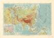
Asie

Sbírka map a diagramů použitých na mírových konferencích v Paříži v letech 1919 - 1920
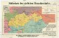
Völkerkarte der nördlichen Karpathenländer
1 : 1000000 Československo Dietrich Reimer
Galizien, Nord-Ungarn, Siebenburgen.
1 : 1863880 Flemming, Carl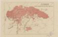
Sbírka map a diagramů použitých na mírových konferencích v Paříži v letech 1919 - 1920
Šo[lcov]a mapa Slovenska
Slovensko Mareš, Vojtěch Haas, František Koppe-Bellmann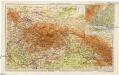
Slovensko a Zakarpatská Ukrajina
1 : 1250000 Bratislava (Slovensko) Kuchař, Karel V. Neubert a synové
VII, uit: General-Karte von Mittel-Europa in 12 Blättern, im Masse 1:1.200.000 / entworfen, bearb. und hrsg. von Josef Schlacher
1 : 1200000 Annotatie: Blad 6 ontbreekt; Annotatie geografische gegevens: 21 maatstokken op blad 9; Legenda op blad 9 Wien : K.K. Militär Geografisches Institut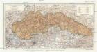
A felvidék közigazgatási térképe
1 : 900000 Podkarpatská Rus (Ukrajina) Kogutowicz, Manó Magyar földrajzi intézet
Partie Septentrionale du Royme. de Hongrie tirée de divers Autheurs.
1 : 880000 Mollova mapová sbírka Sanson, Nicolas Sanson, Nicolas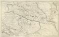
Partie Meridionalle du Rme. de Hongrie tirée de divers Autheurs
1 : 880000 Mollova mapová sbírka Sanson, Nicolas Mariette, Pierre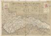
Šolcova mapa Slovenska
1 : 550000 Bratislava (Slovensko) Mareš, Vojtěch Šolc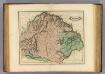
Hungary, Transilvania &c.
1 : 1470000 Lizars, Daniel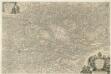
Totius Regni Hungariae una cum Adjacentibus et finitimis Regionibus Delineatio
Mollova mapová sbírka Visscher, Nicolaes Visscher, Nicolaus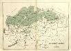
Slovenská oblast v Uhrách
Ungarn, Slowakei, Slowaken
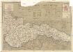
General- Post- und Strassen Karte des Königreich Galizien
1 : 871000 Halič (Polsko a Ukrajina) Schulz, R. A. Artaria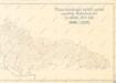
Mapa průměrných ročních srážek republiky Československé za období 1876 - 1902

Hungary and Transilvania
1 : 2800000 Mollova mapová sbírka Moll, Herman Moll, Hermann
[Österreich-Ungarn, Blatt 2]
Adolf Stieler's Handatlas über alle Theile der Erde und über das Weltgebäude Stieler, Adolf Justus Perthes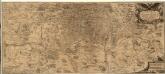
Regni Hvngariae
1 : 700000 Mollova mapová sbírka Reiner, Joannes Alexander Greischer, Mathias